Taşkent
| Taşkent | ||||
|
||||

|
||||
| Basic data | ||||
|---|---|---|---|---|
| Province (il) : | Konya | |||
| Coordinates : | 36 ° 55 ' N , 32 ° 30' E | |||
| Height : | 1532 m | |||
| Surface: | 595 km² | |||
| Residents : | 7,635 (2018) | |||
| Population density : | 13 inhabitants per km² | |||
| Telephone code : | (+90) 332 | |||
| Postal code : | 42960 | |||
| License plate : | 42 | |||
| Structure and administration | ||||
| Mayor : | Osman Arı ( AKP ) | |||
| Website: | ||||
| Taşkent County | ||||
| Residents : | 7,635 (2018) | |||
| Surface: | 595 km² | |||
| Population density : | 13 inhabitants per km² | |||
| Kaymakam : | Ugur Karakaya | |||
| Website (Kaymakam): | ||||
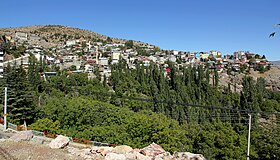
Taşkent is a city and a district in the Turkish province of Konya . Since a regional reform in 2014, the municipality ( Belediye ) is congruent with the district ( İlçe ). All previous villages ( köy ) are now districts ( Mahalle ) of the municipality. The city is located about 110 kilometers south of the provincial capital Konya .
The district is located in the extreme south of the province. It is bordered by Hadim to the west and north , Karaman Province to the east and south, and Antalya Province to the southwest . The D-340 trunk road runs through Taşkent and connects Beyşehir in the north with Mut in the southeast. Bozdağ Tepesi is located in the south of the mountainous district at 2133 meters. The river Balcılar Çayı rises in the southeast and crosses the district to the northwest and flows further north into the Göksu .
Personalities
- Ahmet Davutoğlu (* 1959), Turkish political scientist, politician and Prime Minister
Web links
Individual evidence
- ↑ a b Nufusu.Com , accessed December 15, 2019


