Tekman
| Tekman | ||||
|
||||
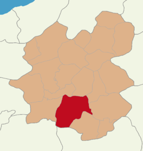
 Location of Tekman within Erzurum |
||||
| Basic data | ||||
|---|---|---|---|---|
| Province (il) : | Erzurum | |||
| Coordinates : | 39 ° 39 ′ N , 41 ° 30 ′ E | |||
| Telephone code : | (+90) 442 | |||
| Postal code : | 25560 | |||
| License plate : | 25th | |||
| Structure and administration (as of 2019) | ||||
| Structure : | 71 mahalles | |||
| Mayor : | Müzahit Karakuş ( HDP ) | |||
| Postal address : | Vatan Mah. 25560 Tekman / ERZURUM |
|||
| Website: | ||||
| Tekman County | ||||
| Residents : | 25,969 (2018) | |||
| Surface: | 2,102 km² | |||
| Population density : | 12 inhabitants per km² | |||
| Kaymakam : | Önder Çengel | |||
| Website (Kaymakam): | ||||
Tekman (formerly Armenian Tatos ) is a city in the district of the same name in the Turkish province of Erzurum and at the same time a district of the Büyükşehir belediyesi Erzurum (metropolitan municipality / metropolitan province ) created in 1993 . Tekman is almost exclusively inhabited by Sunni ( Kurmancî-speaking ) and Alevi ( Kirmancki-speaking ) Kurds . Tekman is located in the south of the province and borders the provinces of Muş and Bingöl . The city of Tekman is 151 km from the center of Erzurum. The weather is characterized by short, cool summers and long, cold winters. The mountainous terrain is on average 1800 m high; in the northwest is the Palandöken Dağı (3271 m), in the north the Kargapazarı Mountains and in the east and southeast the Bingöl Mountains. There are hardly any forests, whereas steppe predominates. The macaw has its source in Tekman .
In 1946, Tekman was split off from Hınıs County and raised to the rank of county. When it was founded, the district comprised 66 villages and 53 hamlets.
Web links
- Website on Facebook
- Website on Twitter
- Mahallelere Göre Erzurum Tekman (list of all districts from 2013, with population and gender)
- Tekman Mahalleleri Nüfusu Erzurum (List of all districts 2012-2018, with population figures )
Individual evidence
- ↑ Nufusu.com Türkiye Nüfusu , accessed October 10, 2019


