
Thal (Bad Groenenbach)
|
Thal
Market Bad Groenenbach
Coordinates: 47 ° 52 ′ 39 ″ N , 10 ° 15 ′ 26 ″ E
|
|
|---|---|
| Height : | 676 m |
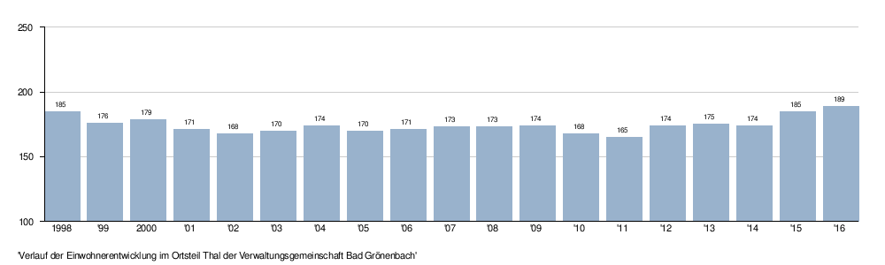
| Residents : | 174 (December 1, 2009) |
| Postal code : | 87730 |
| Area code : | 08334 |
The village of Thal is part of the Kneipp spa Bad Grönenbach in the Unterallgäu district in Bavaria .
geography
topography
The village is located in the Danube-Iller region, about one kilometer east of Bad Grönenbach and about one kilometer west of Wolfertschwenden at an altitude of 676 m above sea level. NN .
geology
Thal is located on gravel from the Worm Ice Age of the Pleistocene . The subsoil consists of gravel and sand .
history
The first mention of Thal was in 1433. From 1683 Thal Grönenbach was affiliated, until then some Memmingen citizens had possessions in Thal. The hamlet of Oberthal, located south of Thal, was called "Sälz" until 1450.

Architectural monuments
A designated 1781 Mittertennbau with half-timbered and gabled roof in Oberthal is a listed building. A former farmhouse with studs and flat gable roof, which is listed as a historical monument, dates from the 17th or 18th century. In Unterthal there is a listed villa, designated 1901, with rich facade decoration in historicizing forms.
Population development
industrial Estate
The Bad Grönenbach industrial park is located in the Thal district. Resident companies with headquarters or branches are among others
traffic
In Thal, the Grönenbach train station is on the Illertalbahn on the Memmingen – Kempten line . The railway line was set up in 1862/1863 two kilometers east of the town of Bad Grönenbach, as the route through the town failed due to resistance from farmers.
See also
Web links
literature
- Bad Grönenbacher Marktnachrichten Christmas Edition 2009
- Hermann Haisch (Ed.): Landkreis Unterallgäu . Memminger Zeitung Verlagsdruckerei, Memmingen 1987, ISBN 3-9800649-2-1 , p. 1013, 1019 .
Individual evidence
- ^ Geological map of Bavaria 1: 500,000. Bavarian State Ministry of Finance, Regional Development and Homeland, accessed on November 22, 2015 .
- ^ Bavarian State Office for Monument Preservation: Entry D-7-78-144-41
- ^ Bavarian State Office for Monument Preservation: Entry D-7-78-144-40
- ^ Bavarian State Office for the Preservation of Monuments: Entry D-7-78-144-42

Bad Grönenbach | Au | Firewood | Darast | Dießlings | Egg | Ehwiesmühle | Hawks | Fautzen | Frauenkau | Gmeinschwenden | Greit | Haitzen | Herbisried | Backsang | Hohmanns | Hörpolz | Hueb | In the Tarrast | Ittelsburg | Klevers | Koppenloh | Kornhofen | Kreuzbühl | Manneberg | Niedergsäng | Niederholz | Oil mill | Raupolz | Rechberg | Rothenstein | Rothmoos | Chess | Schulerloch | Schwenden | Seefeld | Stripes | Thal | Vordergsäng | Waldegg | Wieslings | Cell | Cell wasteland | Ziegelberg | Brick barn