
Tharandter Street
| Tharandter Street | |
|---|---|
|
|
|
 |
|
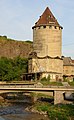
| Tharandter Straße in Plauenschen Grund crosses under the Weißeritztal bridge | |
| Basic data | |
| place | Dresden |
| District | Dölzschen , Löbtau |
| Created | 16th Century |
| Hist. Names | Kohlstrasse, Plauensche Strasse |
| Connecting roads | Dresdner Strasse (in Freital ), Löbtauer Strasse |
| Cross streets | Schillingstrasse, Anton-Weck-Strasse, Oederaner Strasse, Chausseehausstrasse, Clara-Viebig-Strasse, Frankenbergstrasse, Hainsberger Strasse, Mohorner Strasse, Würzburger Strasse, Reisewitzer Strasse, Altfrankener Strasse, Bienertstrasse, Agnes-Smedley-Strasse, Fritz-Schulze-Strasse, Altplauen, Paschkystraße, Coselweg, Serpentinstraße, Heidenschanze, Collmweg, Steigerweg |
| use | |
| User groups | Motor traffic , bicycle traffic , pedestrian traffic , public transport |
| Technical specifications | |
| Street length | 4800 m |
The Tharandter road is a main road between the center of the Dresden district Löbtau and the city limits to Freitaler district Potschappel . It forms part of the State Road 194 and the Silver Road and is about 4.8 km long. The street runs through the Plauenschen Grund and represents the main connection axis between the cities of Dresden and Freital . It is named after the forest town of Tharandt , which can be reached via the Dresdner Straße that follows in Freital .
course


Tharandter Straße begins at the intersection between Kesselsdorfer , Freiberger and Löbtauer Straße in Löbtau-Süd . Then it continues in a southerly direction and follows the river bed of the Weißeritz through the districts of Löbtau and Dölzschen . At the Felsenkeller , Tharandter Strasse crosses the approximately 122-meter-long Plauenscher Grund tunnel (also Felsenkeller tunnel ) and then follows the Weißeritz in a westerly direction. At the Begerburg the road crosses under the Weißeritztalbrücke of the federal motorway 17 and ends 1.5 km further at the Dresden-Freital city limits.
history
The construction of a longer path through the Plauen reason is closely linked to the development of coal mining in the Döhlen basin . On April 29, 1542, Hans Biener received the privilege of mining hard coal between Plauen and Tharandt from the Saxon Duke Moritz . Only a few months later there were further mining privileges. A footpath through the Plauen reason was therefore laid out relatively early for the transport to Dresden. The road to Dresden was still cumbersome from Potschappel via Pesterwitz to Dölzschen or from Potschappel via Coschütz to Plauen. At the beginning of the 18th century, the Dippoldiswalde and Tharandt offices therefore submitted an application to expand and pave the footpath. However, construction work was only granted from Plauen from 1741, followed by expansion to Potschappel in 1745. Further north, the path between the Plauener Weißeritzbrücke and the " Reisewitzschen Garten " was already reinforced in 1729 . Between the Hegereiterbrücke on Felsenkeller and Altplauen, the road ran to the right of the Weißeritz and was only later moved to the current side.
The further development of mining in the region led to the expansion of the roadway in the years 1807–1809. It was initially named "Kohlenstraße", in 1871 it was renamed in Löbtau to "Plauensche Straße" and in 1904 to "Tharandter Straße". After Dölzschen was incorporated into Dresden on July 1, 1945, the Dölzschen section of the street was also given this name.
In 1902 a tram line was already running between Postplatz and Plauen . As a result of the advancing industrialization and the opening up of further mining fields for mining, a railway line to Tharandt had already been built in 1855 , followed by the new construction of the Plauen basic railway via Dölzschen, Potschappel and Döhlen to Deuben in 1902 . After the coal reserves around Döhlen were exhausted in the 1950s and 1960s, the road also lost its importance. The population of the mining and industrial town of Freital, founded in 1921, declined, the tram line became unprofitable and in 1974 it was replaced by bus services between Plauen and Coßmannsdorf (extension there until 1912).

Trams ran on the section between Löbtauer Straße and Altplauen until 1998. Subsequently, bus transport was also used here. The increasing motorization after reunification led to increased traffic on Dresden's streets, including on Tharandter Strasse. The section of road running through Dölzschen was then completely expanded and renovated in the 1990s, the tunnel was built at the rock cellar, as road expansion was not possible in the old route. In Löbtau, renovation work did not begin until 2007. The August flood of the Weißeritz in 2002 had left extensive damage, so the Altplauen bridge had to be completely rebuilt. In the course of the renovation measures from 2007, a roundabout was built at this point , the last rails of the tram disappeared from the street scene , left and right hard shoulders were marked for cyclists.
Development
building
A large part of the old buildings on Tharandter Strasse fell victim to the air raids on Dresden in February 1945. Until the war, the Löbtau Town Hall, inaugurated in 1897, and the Drei-Kaiser-Hof Hotel were among the most representative buildings on Tharandter Strasse. Up until then, mainly industry had settled between the east side of the street in Löbtau and the Weißeritz. The iron foundry Buschbeck & Hebenstreit, the gas and petrol engine construction company Hille and the chocolate factory Petzold & Aulhorn had their production facilities here. Other companies on Tharandter Strasse were Schulze & Schultz Apparatebauanstalt, Eisenhammerwerk Dölzschen (König-Friedrich-August-Hütte) and the Dresden knitting machine factory. These factories were also hit by the air raids, and several houses on Tharandter Strasse were destroyed. The companies that survived the war were then converted into state- owned companies (VEB) in the GDR .
The factory building at Tharandter Strasse 33 was used in the GDR by VEB clutch and engine construction. After the fall of the Berlin Wall they were used as a rehearsal stage for the Dresden State Theater and until 2004 they were home to the “Theater in the Factory”. In 2006, in the premises of an open cinema , the "cinema in the factory". In addition, a number of more modern buildings were built on Tharandter Strasse after 1990, such as the “Drei-Kaiser-Hof” (2000) and the “Löbtau-Passage” (2009) shopping centers. Existing residential buildings were mostly renovated, and many industrial buildings were demolished after the companies went bankrupt. In addition, several petrol stations are located on the busy arterial road; three petrol stations are still open today.
While the streetscape in Löbtau is still urban, there are only a few houses and factory buildings in Dölzschen. The largest complex in this area is the former Felsenkeller brewery ( Dresdner Felsenkeller ), which is now used as a commercial center. The brewery had already settled on the site in the middle of the 19th century. In addition, a few mills were built on the Weißeritz in Plauenschen Grund in the 19th century, some of which have still been preserved. The houses of the former "Königsmühle", now residential buildings, are located directly at the southern tunnel exit. The former bread factory of the König-Friedrich-August-Mühlenwerke AG is more striking. Its high tower can be seen from afar and is a landmark of the Plauen reason. Concepts for using the vacant factory have so far failed.
Several Dresden cultural monuments are located on Tharandter Straße. These include some tenement houses in Löbtau, the Hegereiterbrücke at the Felsenkeller, the old Plauen train station, the buildings of the Königsmühle, parts of the Felsenkellerbrauerei and the König-Friedrich-August-Hütte (former tavern). The few houses in Niederdölzschen on the roadside are largely unrenovated due to their unattractive location on the main road and railway line.
The silo tower of the König-Friedrich-August-Mühlenwerke AG
Former warehouse of the Königsmühle, now a residential building

Tenement houses Tharandter Strasse 77

SDV Die Medien AG, a renovated industrial ruin; Tharandter Strasse 35


Plauenscher Grund tunnel

The construction of the tunnel at Felsenkeller was related to the fundamental expansion of Tharandter Straße from 1990, which was planned in GDR times, but was delayed by the fall of the Wall. In this section the road led around a rock massif that stood in the way of expansion. Since it was too cumbersome to blast away parts of the rock, the new construction of the first and still shortest road tunnel in the new federal state of Saxony was planned.
On June 25, 1991, work began on the tunnel from Dresden. It was blasted up to four times a day, and the builders needed around 100 kilograms of explosives for each blast. On July 31, 1991 the breakthrough in the 122 meter long tunnel was reached. This was followed by cladding and sealing work as well as road construction through the new structure. The inauguration of the tunnel took place on February 26, 1992.
traffic

There are two lanes for road traffic, which are over-wide in Dölzschen, as cyclists ride there on the wide footpath to the Weißeritz. From the tunnel there are marked cycle lanes on both sides in the direction of Dresden . Since cyclists are not allowed to pass through the road tunnel, the bicycle traffic in this section is led over the old route of Tharandter Straße around the tunneled rock massif.
The bus line A of the regional traffic Sächsische Schweiz-Osterzgebirge , the successor to the tram line, runs over Tharandter Straße , but only to the junction with Reisewitzer Straße. Bus routes offered by the Dresden transport company are bus route 62 (Dölzschen – Johannstadt), 63 (Löbtau – Pillnitz / Graupa / Bonnewitz), 85 (Striesen – Löbtau-Süd) and 90 (Löbtau – Gompitz). There are seven bus stops on Tharandter Strasse, four of them in Dölzschen and three in Löbtau.
Web links
- History of Tharandter Straße on dresdner-stadtteile.de
Individual evidence
- ↑ S. Janetz & S. Stute: The Döhlener basin - history of a landscape . 2006, p. 20 ( digital version as PDF file; 2 MB ).
- ↑ Juliane Puls: Freital. On the way to the city . Erfurt 2000, ISBN 3-89702-227-3 .
- ^ Expansion of Tharandter Strasse. In: dresden.de. State capital Dresden, May 30, 2007, accessed on August 16, 2015 (press release).
- ↑ Photos & History ( Memento of the original from March 26, 2013 in the Internet Archive ) Info: The archive link was inserted automatically and has not yet been checked. Please check the original and archive link according to the instructions and then remove this notice. , Site of the cinema in the factory
- ↑ Cultural monuments in the Dresden themed city map
- ↑ The flying stones from Plauen reason . In: Sächsische Zeitung , September 13, 2013
Coordinates: 51 ° 1 ′ 32.9 ″ N , 13 ° 41 ′ 59.6 ″ E