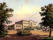
Udanin
| Udanin | ||
|---|---|---|

|
|
|
| Basic data | ||
| State : | Poland | |
| Voivodeship : | Lower Silesia | |
| Powiat : | Środa Śląska | |
| Geographic location : | 51 ° 2 ' N , 16 ° 27' E | |
| Residents : | 982 (Jan. 1, 2008) | |
| Postal code : | 55-340 | |
| Telephone code : | (+48) 76 | |
| License plate : | DSR | |
| Economy and Transport | ||
| Street : | motorway A4 | |
| Next international airport : | Wroclaw | |
| Gmina | ||
| Gminatype: | Rural community | |
| Gmina structure: | 23 localities | |
| 19 school authorities | ||
| Surface: | 110.70 km² | |
| Residents: | 5082 (Jun. 30, 2019) |
|
| Population density : | 46 inhabitants / km² | |
| Community number ( GUS ): | 0218052 | |
| Administration (as of 2010) | ||
| Community leader : | Teresa Olkiewicz | |
| Address: | Udanin 26 55-340 Udanin |
|
| Website : | www.udanin.pl | |
Udanin ( u'danin , German : Gäbersdorf ) is a village and seat of the rural municipality of the same name in the Lower Silesian Voivodeship in Poland .
Until 1945 the village belonged to the German Empire , Striegau district, Lower Silesia.
geography
Udanin is located in southwest Poland about 42 kilometers from Wroclaw and 28 kilometers from Legnica . Neighboring municipalities are Środa Śląska , Kostomłoty , Zarow , Mściwojów and Wądroże Wielkie .
local community
The rural community of Udanin is composed of 23 places with 19 districts ( German names until 1945 ) including the Schulzenamt:
|
|
Other localities in the municipality are: Dębki ( Eichberg ), Dębnica, Jańczów and Księżyce.
In total, fewer than 6000 people live in the community. The largest towns in Gmina are Udanin with 982 inhabitants, Ujazd Górny with 596 inhabitants and Ujazd Konary with 503 inhabitants.
Economy and Infrastructure
The community is largely rural in character. 86 percent of their area is used for agriculture , 10 percent is used in the municipal area, only 4 percent is used for forestry . The fertile soils are mainly used for agriculture . The community is rich in raw materials such as clay and brown coal .
In the last 19 years, 1,340 households have been connected to the water supply, meaning that water and sewage connections are available in almost all localities in the municipality. A modern sewage treatment plant was built in Piekary.
The Strzegom – Marciszów railway line is closed, and with it the Piekary Udanin station. The A4 motorway runs through the municipality. The nearest airport is in Wroclaw .
The community's primary school was recently modernized and equipped with a sports hall. The construction of a kindergarten is planned for the next few years.
Culture and sights
There are several historical churches in the localities of the parish. The Church of St. Ursula in Udanin was built in 1250.
Furthermore, many anglers are attracted by the reservoirs in the region.
Daughters and sons of the place
- Karl von Richthofen (1811–1888), German legal historian and lawyer
Web links
- Website of the municipality of Udanin
- http://www.dhm.de/lemo/forum/kollektives_gedaechtnis/228/index.html
Individual evidence
- ↑ population. Size and Structure by Territorial Division. As of June 30, 2019. Główny Urząd Statystyczny (GUS) (PDF files; 0.99 MiB), accessed December 24, 2019 .
- ↑ The Genealogical Place Directory
- ↑ Description of Gmina Udanin ( Memento of the original from December 20, 2009 in the Internet Archive ) Info: The archive link was inserted automatically and has not yet been checked. Please check the original and archive link according to the instructions and then remove this notice.


