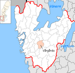
Vårgårda (municipality)
| Vårgårda municipality | |||||
|---|---|---|---|---|---|
|
|||||
| State : | Sweden | ||||
| Province (län): | Västra Götalands län | ||||
| Historical Province (landskap): | Västergötland | ||||
| Main place: | Vårgårda | ||||
| SCB code: | 1442 | ||||
| Residents : | 11,810 (December 31, 2019) | ||||
| Area : | 441.2 km² (January 1, 2016) | ||||
| Population density : | 26.8 inhabitants / km² | ||||
| Website : | www.vargarda.se | ||||
| List of municipalities in Sweden | |||||
Coordinates: 58 ° 2 ′ N , 12 ° 48 ′ O Vårgårda is a municipality ( Swedish commun ) in the Swedish province of Västra Götalands län and the historic province of Västergötland . The main town of the municipality is Vårgårda .
history
The Kyllinga-kullen burial ground is north of Vårgårda .
Before the merger of Älvsborgs län , Skaraborgs län and Göteborgs och Bohus län to Västra Götalands län , Vårgårda belonged to the province of Älvsborgs län.
places
Both places are localities ( tatorter ):
Web links
Commons : Vårgårda Municipality - Collection of pictures, videos and audio files
- Official website (Swedish, German)
- Prehistoric times
Individual evidence
- ↑ Folkmängd i riket, län och kommuner December 31, 2019 at Statistiska centralbyrån
- ↑ Kommunarealer January 1, 2016 at Statistiska centralbyrån (including all inland waters)

