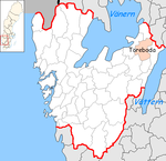
Töreboda (Municipality)
| Töreboda municipality | |||||
|---|---|---|---|---|---|
|
|||||
| State : | Sweden | ||||
| Province (län): | Västra Götalands län | ||||
| Historical Province (landskap): | Västergötland | ||||
| Main place: | Töreboda | ||||
| SCB code: | 1473 | ||||
| Residents : | 9293 (December 31, 2019) | ||||
| Area : | 591.1 km² (January 1, 2016) | ||||
| Population density : | 15.7 inhabitants / km² | ||||
| Website : | www.toreboda.se | ||||
| List of municipalities in Sweden | |||||
Coordinates: 58 ° 42 ' N , 14 ° 8' E
Töreboda is a municipality ( Swedish : kommun ) in the Swedish province of Västra Götalands län and the historic province of Västergötland .
The main town of the municipality is Töreboda , other notable towns are
- Beateberg
geography
The municipality of Töreboda is a hilly country shaped by the Ice Age. There are several lakes on the municipal boundary: to the west of Törboda is Lake Ymsen, to the southwest of the Vogelsee Östen , to the northeast of the Unden lake and to the southeast of the Viken lake . From Viken, the highest body of water in the Göta Canal , the canal stretches northeast through the main town of Töreboda, where the main railway line Stockholm - Gothenburg crosses the canal.
At Älgarås, 18 kilometers north of the central town of Töreboda, King Sverker Karlsson put down an uprising in 1205 by the pretenders of the Erik family.
economy
The municipality of Töreboda has an above-average share of agricultural workers, but the industrial sector is also strong. Small and medium-sized businesses predominate.
Personalities
- Fredrik von Otter (1833–1910), admiral and prime minister
Web links
- Official website (German, English, Swedish)
Individual evidence
- ↑ Folkmängd i riket, län och kommuner December 31, 2019 at Statistiska centralbyrån
- ↑ Kommunarealer January 1, 2016 at Statistiska centralbyrån (including all inland waters)


