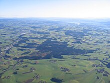
Vöckla-Ager hill country
The Vöckla-Ager-Hügelland is one of the 41 Upper Austrian spatial units and is located in the Traunviertel and Hausruckviertel .
location
The spatial unit is located in the districts of Braunau , Gmunden and Vöcklabruck and consists of two sub-areas.
The area of the Vöckla-Ager hill country is around 225 km² and extends over around 36 km. The maximum width is 13 km. The deepest part of the area is at Frankenmarkt at around 530 m above sea level. A. The highest area is the border to the neighboring, southern spatial unit at around 700 m above sea level. A.
The following municipal areas are predominantly or entirely in the Vöckla-Ager hill country (in alphabetical order): Attersee , Berg im Attergau , Frankenmarkt , Gampern , Lenzing , Pfaffing , Pöndorf , Regau , Seewalchen , St. Georgen , Vöcklamarkt and Weißenkirchen .
The spatial unit is surrounded by the following Upper Austrian spatial units (clockwise, starting in the north): Mattigtal , Hausruck and Kobernaußerwald , Inn- and Hausruckviertler Hügelland , Vöckla-Agertal , Ager-Traun-Terrassen , Traun-Enns-Riedelland , Traun and Atterseer Flysch Mountains , Attersee-Mondsee basin and Mondsee Flysch Mountains . The Vöckla-Agertal divides the spatial unit into two areas.
Characteristic
- The spatial unit is a gently rolling moraine landscape
- The proportion of forest is low (10 to 15%). Spruce forests are predominantly to be found, e.g. B. Eggenberg Forest . Small forests close to nature can be found in stream valleys.
- The flowing waters drain towards Vöckla and Ager and are mostly close to nature. Trees accompanying the banks are rare.
- There are two important moors , the Gerlhamer Moor and the Kreuzbauernmoor .
- The area is predominantly used for agriculture ( arable farming and grassland ) and is home to many natural cultural landscape elements . Wet and dry meadows are rarely found.
- The settlement areas are mostly hamlets or individual farms. The central places (St. Georgen, Schörfling, Seewalchen) are dominant and have scattered settlements.
- Important traffic connections ( West Autobahn and Westbahn ) lead through the spatial unit and cut it up.
literature
- Office of the Upper Austrian Provincial Government, Nature Conservation Department (Ed.): Nature and Landscape / Guiding Principles for Upper Austria. Volume 22: Vöckla-Ager-Hügelland spatial unit . Linz and Vienna 2007 ( pdf [accessed on February 18, 2017]).
Web links
- Map of the Vöckla-Ager-Hügelland spatial unit. In: DORIS . Retrieved November 30, 2014 .
- Vöckla-Ager hill country. In: Nature and Landscape in Upper Austria. Retrieved November 30, 2014 .

