Berg in the Attergau
|
Berg in the Attergau
|
||
|---|---|---|
| coat of arms | Austria map | |
|
|
||
| Basic data | ||
| Country: | Austria | |
| State : | Upper Austria | |
| Political District : | Vöcklabruck | |
| License plate : | VB | |
| Surface: | 20.57 km² | |
| Coordinates : | 47 ° 57 ' N , 13 ° 32' E | |
| Height : | 654 m above sea level A. | |
| Residents : | 1,072 (January 1, 2020) | |
| Postal code : | 4880 | |
| Area code : | 07667 | |
| Community code : | 4 17 06 | |
| NUTS region | AT315 | |
| Address of the municipal administration: |
Attergaustr. 36 4880 Berg im Attergau |
|
| Website: | ||
| politics | ||
| Mayor : | Ernst Pachler ( ÖVP ) | |
|
Municipal Council : (2015) (13 members) |
||
| Location of Berg im Attergau in the Vöcklabruck district | ||
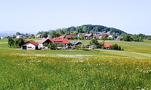
 View of Berg im Attergau, the main town in the municipality |
||
| Source: Municipal data from Statistics Austria | ||
Berg im Attergau is a municipality in Upper Austria in the Vöcklabruck district in the Salzkammergut with 1072 inhabitants (as of January 1, 2020). The community is located in the judicial district of Vöcklabruck .
geography
Berg im Attergau lies at an altitude of 654 m in the Hausruckviertel. The extension is from north to south 10 km, from west to east 5.7 km. The total area is 20.4 km², 30.4% of the area is forested, 61.3% of the area is used for agriculture.
Community structure
The municipality includes the following 16 localities (population in brackets as of January 1, 2020):
- Tree (29)
- Berg im Attergau (166)
- Brandham (31)
- Eggenberg (80)
- Eisenpalmsdorf (32)
- English year (63)
- Hipping (204)
- Jedlham (74)
- Katterlohen (22)
- Poessing (50)
- Raith (17)
- Rixing (71)
- Rubensdorf (24)
- Thanham (56)
- Walsberg (91)
- Woetting (62)
The community consists of the cadastral communities Berg and Eggenberg.
Berg also borders the Attersee.
coat of arms
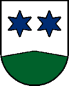
Blazon : "In silver, a green, flat tip, above it two blue, six-pointed stars." The community colors are green and white.
The coat of arms, awarded in 1978, shows the place name with the green mountain, whereby the green color indicates agriculture and tourism as the most important occupations of the residents. The two stars stand for the two formerly independent communities of Berg and Eggenberg, which were merged in 1938.
history
The story of Berg im Attergau is closely linked to that of St. Georgen im Attergau. Originally located in the eastern part of the Duchy of Bavaria, the place belonged to the Duchy of Austria since the 12th century. Since 1490 it has been assigned to the Principality of Austria ob der Enns .
Berg has been an independent municipality since 1848. The current municipality of Berg emerged from the two independent municipalities Berg and Eggenberg by merging in 1938.
Ring wall system on the Buchberg
In 1974 archaeological excavations led by Clemens Eibner discovered the outlines of a 400-meter-long ring wall . It can be assumed that around 1500 BC The inhabitants of the pile dwellings gave up their settlements on the lake and moved up here. The facility itself was only attached later.
Only a few finds (ceramics, pottery shards) came to light, but it is certain that the Buchberg summit was inhabited for a very long time. The walls and towers, of which the foundations were exposed, did not come into being until the first centuries after Christ.
Barrows
In the vicinity of Berg there are a large number of barrows from the Latène period , three of which were opened by the Federal Monuments Office in 2005 and 2006 . After the inn in Baum, the exhibition is now shown in the House of Culture in St. Georgen im Attergau.
politics
The municipal council has a total of 13 members. With the municipal council and mayoral elections in Upper Austria in 2015 , the municipal council has the following distribution: 10 ÖVP, 2 FPÖ and 1 SPÖ.
- mayor
- since 2014 Ernst Pachler (ÖVP)
Deputy Mayor of the community is Alois Egle (ÖVP).
Population development
In 1991 the municipality had 1,106 inhabitants according to the census, then 987 inhabitants in 2001 and 1,003 inhabitants according to the 2008 census.
Culture and sights
Campground of the boy scouts
At least since 1969 and since 1973 (over 1000 participants) every 5 years and most recently for the 14th time in 2018 (with arrival by special train Linz– Vöcklamarkt ), 2 km northeast of St. Georgen near the village of Eggenberg, a 10-day international event takes place around August Large camp of several thousand scouts in tents on and near the 50,000 m 2 “Scout Camp Austria” (formerly: Landeslagergelände ) on the left bank of the Dürren Ager .
The high ropes course High Kix has been located in the south-east corner of the camp site since at least 2009 .
Web links
- Map in the Digital Upper Austrian Room Information System ( DORIS )
- 41706 - Berg im Attergau. Community data, Statistics Austria .
- Further information about the municipality of Berg im Attergau can be found on the geographic information system of the federal state of Upper Austria .
Individual evidence
- ↑ Statistics Austria: Population on January 1st, 2020 by locality (area status on January 1st, 2020) , ( CSV )
- ^ Province of Upper Austria: Coat of arms of the municipality of Berg iA
- ↑ Berg im Attergau in the Atterwiki from June 25, 2013
- ^ Jewels in the district: Barrows in Berg / Attergau in BezirksTV from June 25, 2013
- ↑ http://www.atterwiki.at/index.php?title=Berg_im_Attergau#Vereine_und_Organisations Berg im Attergau> Museen, atterwiki.at, accessed October 30, 2015.
- ↑ Archive link ( Memento of the original from March 4, 2016 in the Internet Archive ) Info: The archive link was inserted automatically and has not yet been checked. Please check the original and archive link according to the instructions and then remove this notice. Scout group Kronstorf, Upper Austria, accessed October 30, 2015.
- ↑ HOME2018: 14th international regional warehouse in Upper Austria home2018.at, 2018, accessed February 2, 2020.
- ↑ My heart goes boom boom boom Nicola Raunig, August 20, 2013, accessed October 30, 2015.
- ↑ 13. Internat. Scout camp in St. Georgen im Attergau mein district.at, August 8, 2013, accessed February 2, 2020.
- ↑ Scout Camp Austria website, accessed October 30, 2015.
- ↑ The title was: AQUA! : The Water Jamboree 2008, My heart goes boom boom: Planet'13, Here, There and Everywhere: HOME18.
- ^ High Kix website, accessed October 30, 2015.


