Puchkirchen am Trattberg
|
Puchkirchen am Trattberg
|
||
|---|---|---|
| coat of arms | Austria map | |
|
|
||
| Basic data | ||
| Country: | Austria | |
| State : | Upper Austria | |
| Political District : | Vöcklabruck | |
| License plate : | VB | |
| Surface: | 7.72 km² | |
| Coordinates : | 48 ° 4 ' N , 13 ° 34' E | |
| Height : | 558 m above sea level A. | |
| Residents : | 1,063 (January 1, 2020) | |
| Population density : | 138 inhabitants per km² | |
| Postal code : | 4849 | |
| Area code : | 07682 | |
| Community code : | 4 17 27 | |
| NUTS region | AT315 | |
| Address of the municipal administration: |
Puchkirchen 3 4849 Puchkirchen am Trattberg |
|
| Website: | ||
| politics | ||
| Mayor : | Anton Hüttmayr ( ÖVP ) | |
|
Municipal Council : (2015) (13 members) |
||
| Location of Puchkirchen am Trattberg in the Vöcklabruck district | ||
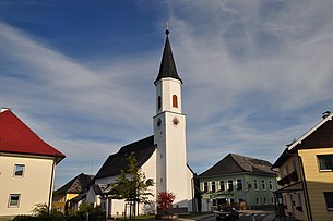
 Town center with parish church |
||
| Source: Municipal data from Statistics Austria | ||
Puchkirchen am Trattberg is a municipality in the Austrian state of Upper Austria in the district of Vöcklabruck in the Hausruckviertel with 1063 inhabitants (as of January 1, 2020). The competent district court is in Vöcklabruck .
geography
Puchkirchen am Trattberg is located 557 m above sea level in the Hausruckviertel between the Hausruck in the north and the Salzkammergut in the south. It is located on the Trattberg , which is in front of the Göbelsberg in the south. The extension is 2.8 km from north to south and 5 km from west to east. The total area is 7.7 km². 22.1% of the area is forested, 67.5% of the area is used for agriculture.
The only cadastral community is Puchkirchen.
Population development
In 1991 the municipality had 868 inhabitants according to the census, in 2001 it had 948 inhabitants.
coat of arms
Official description of the municipal coat of arms awarded in 1984: oblique square of red and gold; at the top a golden, growing Latin end-cabbage cross adjoining the upper edge of the shield; below a silver, upright drill bit head; on the right and left a green beech leaf sloping outwards. The community colors are yellow-green-yellow.
The cross and beech leaves symbolize the place name as a talking coat of arms . The drill bit is reminiscent of the first successful deep drilling for crude oil in Upper Austria, known as "Puchkirchen 1", in 1956, which took place on the municipal boundary of Neukirchen an der Vöckla .
history
Originally located in the eastern part of the Duchy of Bavaria, the place belonged to the Duchy of Austria since the 12th century. Written sources from this time cannot be reliably assigned to Puchkirchen. In 1480 the place is mentioned for the first time in a land register of the Frankenburg rule. Since 1490 it has been assigned to the Principality of Austria ob der Enns .
During the Napoleonic Wars , the place was occupied several times. Since 1816 back in Austria ob der Enns , this crown land became the federal state of Upper Austria in 1918.
After the annexation of Austria to the German Reich on March 13, 1938, the place belonged to the Gau Oberdonau . After 1945 the restoration of Upper Austria took place.
politics
The municipal council has a total of 13 members. With the municipal council and mayoral elections in Upper Austria in 2015 , the municipal council has the following distribution: 9 ÖVP and 4 FPÖ.
- Mayor since 1945
- 1945–1946 Johann Stadlbauer (ÖVP)
- 1946–1949 Anton Kaiser (ÖVP)
- 1949–1961 Johann Kinast (ÖVP)
- 1961–1979 Josef Schlager (ÖVP)
- 1979–2001 / 02 Adolf Gaisbauer (ÖVP)
- 2002–2007 Barbara Anna Moritz (ÖVP)
- since 2007 Anton Hüttmayr (ÖVP)
Culture and sights
- Parish church Puchkirchen am Trattberg : The Catholic parish church was first mentioned in a document in 1480. It is consecrated to St. James the Elder and was redesigned in 2000/2001 with the participation of the parishioners.
- In 1784 Puchkirchen ceased to be a branch of the Neukirchen an der Vöckla parish and became a "locality". In 1806 the parish was again attached to Neukirchen before the "Lokalie" was rebuilt in 1847. Puchkirchen has been a full parish since 1891.
Economy and Infrastructure
In Puchkirchen, an underground gas storage facility operated by RAG in former oil storage facilities at a depth of up to 1,600 m is used as a reserve. Natural gas supplied is then pumped back into the ground at a pressure of 100 - 120 bar .
literature
- Hermann Fraunberger: Family and house names of the residents of Puchkirchen am Trattberg , 1977.
- Festschrift for the award of the municipal coat of arms and for the 200th anniversary of the parish. Published by the community of Puchkirchen. Design: Josef Kaltenbrunner, 1984.
- Josef Kaltenbrunner: Puchkirchen am Trattberg in the Second World War (1939-1945). A small community history on the occasion of 70 years of the end of the war in 2015. , 2015. ( online )
Web links
- Map in the Digital Upper Austrian Room Information System ( DORIS )
- 41727 - Puchkirchen am Trattberg. Community data, Statistics Austria .
- More information about the community of Puchkirchen am Trattberg on the geo-information system of the federal state of Upper Austria .


