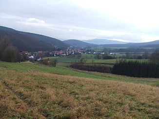
Vierbach (weirs)
| Vierbach | ||
|
View from the Vierbach grill hut near the village of Vierbach to the |
||
| Data | ||
| Water code | EN : 4188 | |
| location | Werra-Meissner district , Hesse , Germany | |
| River system | Weser | |
| Drain over | Weirs → Werra → Weser → North Sea | |
| Headwaters | near Meißner- Germerode am Hohen Meißner 51 ° 12 '1 " N , 9 ° 52' 27" E |
|
| Source height | approx. 430 m above sea level NHN | |
| muzzle | at Wehretal- Reichensachsen in the weirs coordinates: 51 ° 9 '29 " N , 9 ° 59' 35" E 51 ° 9 '29 " N , 9 ° 59' 35" E |
|
| Mouth height | approx. 175 m above sea level NHN | |
| Height difference | approx. 255 m | |
| Bottom slope | approx. 20 ‰ | |
| length | 12.5 km | |
| Catchment area | 21.22 km² | |
| Left tributaries | see section catchment area and tributaries |
|
| Right tributaries | see section catchment area and tributaries |
|
The Vierbach is a 12.5 km long, western and orographically left tributary of the weirs in the north Hessian Werra-Meißner-Kreis ( Germany ).
course
The Vierbach, which flows entirely in the Frau-Holle-Land Geo-Nature Park (Werratal.Meißner.Kaufunger Wald) rises on the eastern flank of the Hoher Meissner ( 753.6 m above sea level ). Its source is west of Germerode , a part of the municipality of Meißner , at an altitude of about 430 m .
Initially, the Vierbach flows east to Germerode, from where it turns south-east along state road 3243. A few kilometers after flowing through this village and a little after passing the Queckmühle , the flowing water runs through the village of Vierbach , a district of the municipality of Wehretal . Then the stream passes the brewery mill and runs eastward in its lower course.
Finally, after passing under the Kanonenbahn , the Bebra – Göttingen railway line and the Bebra-Göttingen federal road and after passing the Riedmühle , the Vierbach flows a little northwest below the village of Reichensachsen , which is not directly on the Vierbach , the seat of the municipal administration of Wehretal, on its last meters Coming from the south-south-west at an altitude of around 175 m in the southern Werra tributary weirs .
Catchment area and tributaries
The tributaries of the Vierbach, whose catchment area covers 21.22 km², include with orographic allocation (l = left-hand side, r = right-hand side), length of water, mouth with Vierbach kilometers and - if known - catchment area (viewed downstream) :
- Cold water (l; 0.5 km), above Germerode (near km 12.15)
- Eichbach (r; 1.8 km), below Germerode, above the Queckmühle (near km 7.65), 2.526 km²
- Finkenbach (r; 1.2 km), below Germerode, below the Queckmühle (near km 7.4)
