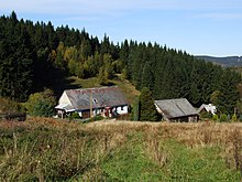
Zálesí (Javorník)
| Zálesí | ||||
|---|---|---|---|---|
|
||||
| Basic data | ||||
| State : |
|
|||
| Region : | Olomoucký kraj | |||
| District : | Jeseník | |||
| Municipality : | Javorník | |||
| Area : | 1929 ha | |||
| Geographic location : | 50 ° 22 ' N , 16 ° 56' E | |||
| Height: | 662 m nm | |||
| Residents : | 35 (2011) | |||
| Postal code : | 790 70 | |||
| License plate : | M. | |||
| traffic | ||||
| Street: | Javorník - Zálesí | |||
Zálesí , until 1949 Valdek (German Waldek ) is a district of the town of Javorník in the Czech Republic . It is located seven kilometers southwest of Javorník and four kilometers east of Lądek-Zdrój directly on the border with Poland .
geography
Zálesí extends in the valley of Obecní potok in the Travenská hornatina ( Krautenwalder Bergland ), a part of the Reichensteiner Mountains . To the north rises the Travná ( Krautenwälder Berg ; 711 m), at the foot of which the Krautenwalder or Landecker Pass (Polish: Przełęcz Lądecka , Czech: Travenské sedlo ) crosses the mountains. In the northeast of Merice (located Schöffel Berg , 671 m), behind the Račí údolí ( Krebstal ) with the remains of castles Rychleby ( Reichenstein ) and the Pustý zámek ( Ödschloss ). To the southeast lies the Prostřední vrch ( Mittelberg , 726 m) and in the south on the border of the Koníček ( Rösslberg , 850 m) and on Polish terrain the Karpenstein castle ruins .
Neighboring towns are Travná in the north, Podměstí and Horní Fořt in the northeast, Uhelná and Červený Důl in the east, Nové Vilémovice in the southeast, Nowy Gierałtów and Stary Gierałtów in the south, Lądek-Zdrój in the southwest, Lutynia in the west and Wrzosówka in the northwest. Zálesí can only be reached via a cul-de-sac that ends in town.
history
Waldek was first mentioned in a document in 1558. At that time, the village consisted of 30 rural properties. After the cession of the County of Glatz to Prussia, the village came into a border position in 1742, but remained with Austria. Until the 19th century, the mountain village that belonged to the Johannesberg rulership grew little. Around 1850 there were two lime kilns in Waldek and limestone and basalt were extracted in two quarries. These were shut down after 1900.
After the abolition of patrimonial , the village, consisting of the districts of Ober Waldek and Nieder Waldek, formed a community in the Freiwaldau district from 1850 . At the beginning of the 20th century, attempts to mine iron ore began, which were discontinued after a short time. In 1930 the village had 456 inhabitants. After the Munich Agreement , Waldek was added to the German Reich and belonged to the Freiwaldau district from 1939 to 1945 . The population remained unchanged in 1939 compared to 1930. After the Second World War it was renamed Valdek and the German residents were expelled . In 1949 the place name was changed to Zálesí and the village was incorporated into Travná.
Zálesí has been part of Javorník since 1961. In 1991 the place had 7 residents. In 2001 the village consisted of 25 houses in which 20 people lived. The village is now a resort.
Mining

After a uranium deposit was discovered at the northern foot of the Prostřední vrch in the summer of 1957, its exploration began in the autumn of the same year. The houses in the village, which was barely populated after the eviction, were taken over by the Jáchymovsk é doly (Joachimsthaler Pits) state enterprise and temporary operating facilities were set up there. In 1959 the excavation took place on three levels and in 1962 a blind shaft was sunk from the 3rd level to a further 106 meters depth, from which the 4th and 5th levels were developed. In 1968 the mine was closed. In the eleven-year operation, 23.6 km of routes were driven into the mountain and 23 corridors and debris were removed.
A total of 405.3 tons of uranium were extracted in Zálesí. In addition, the former three tunnels are a well-known site with a great variety of minerals. In addition to the uranium minerals autunite , kasolite , Liebigite , uraninite , uranophane , uranopilite and uranospinite, a total of around 150 different minerals or varieties have been found so far (as of 2013) , such as bohdanowiczite , chalcopyrite , devillin , erythrin , guérinite , naumannite , Rammelsbergite , Skutterudite , Vanadinite and Wölsendorfite .
For the 2009 discovered mineral Litochlebit and named after its place of discovery mineral Zálesíit also Zálesí considered as type locality .
Local division
Zálesí includes the one-layer Černý kout ( Black Mountain Houses ).
Attractions
- Remains of a lime kiln
- Former uranium mine
literature
- Jiří Sejkora, Petr Pauliš, Jaromír Tvrdý: Zálesí - an interesting mineral discovery site on the Czech-Polish border. In: Lapis. Vol. 33, No. 10, 2008, ISSN 0342-2933 , pp. 22-36.
Individual evidence
- ↑ http://www.uir.cz/katastralni-uzemi/657964/Zalesi-u-Javornika
- ↑ Portál Veřejné Správy ( Memento of the original from February 10, 2008 in the Internet Archive ) Info: The archive link was automatically inserted and not yet checked. Please check the original and archive link according to the instructions and then remove this notice.
- ↑ Mindat - description of the location and mineral list for Zálesí ( Zalesie ), Javorník ( Jauernig ), Olomouc Region, Moravia (Moravia; Maehren), Czech Republic (English)
Web links
- Czeska kopalnia uranu Javornik - Zalesie - Description of the former uranium mine with photos (in Polish).
- Dobývání uranu - Zálesí u Javorníka Part 1 and Part 2 - slide show with old and present photos and maps of the former uranium mine (in Czech).


