Zone B
| Zone B of the Free Territory of Trieste (official) | |
|---|---|
 |
|
| Basic data | |
| Country | Trieste Free Territory |
| Capital | Twill |
| surface | 515.5 km² |
| Residents | 71,000 (1947) |
| density | 138 inhabitants per km² |
Coordinates: 45 ° 28 ' N , 13 ° 45' E
The zone B was one of the two zones of the military managed Free Territory Trieste and formed the southern part of the small state. It existed from 1947 to 1954.
location
Zone B included the entire coast of the Slovenian region Obalno-kraška , a part of the historical region of Primorska , and the northwest of the Croatian Istria . In the west the zone bordered the Adriatic Sea with the Gulf of Trieste , in the north on Zone A , which was occupied and administered by the British Army and the United States Army , and in the south and east on the Federal People's Republic of Yugoslavia . The border zone A formed the flow Dragonja .
Zone B had an area of 515.5 square kilometers and was almost twice as large as Zone A.
The largest city in the zone was the seaport city of Koper , which is now part of Slovenia. It formed the second largest city in the entire territory, after the capital Trieste .
history
Until the end of the First World War, the area of zone B belonged to the coastal land , a crown land of Cisleithania within the Austro-Hungarian monarchy , and came into being in the Rapallo border treaty of 1920 between the Kingdom of Italy and the Kingdom of Serbs, Croats and Slovenes (from 1929 Kingdom Yugoslavia ) to the Kingdom of Italy and became part of the Region of Venezia Giulia . The zone was not established as a separate administrative unit until 1947. It was established on September 15, 1947 with the proclamation of the Free Territory of Trieste.
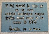
Zone B existed until 1954 and was de facto dissolved with the signing of the so-called London Memorandum by representatives of Italy, Yugoslavia, the United Kingdom and the United States on October 5, 1954. Officially, it was only placed under Yugoslav administration at that time and de jure only dissolved on November 10, 1975 with the Treaty of Osimo . It was divided between the Socialist Republic of Slovenia and the Socialist Republic of Croatia .
Demographics
According to the 1946 census, which took place before the state was established, the area of Zone B was about 68,000 people. Most of the residents lived in the countryside. Zone B's population consisted predominantly of Italians , Slovenes and Croats . The minorities included Jews and Austrians .
| Etnia | number | Percentage |
|---|---|---|
| Italian | 51,000 | 70% |
| Slovenes and Croatians | 17,000 | 30% |
| Total | 68,000 | 100% |
A more precise estimate by the United Nations (UN) in 1949 revealed the following ethnic composition of zone B. It is estimated that between 36,000 and 55,000 Italians and between 12,000 and 17,000 Slovenian and Croatian residents lived in the area.
Although Yugoslavia under Josip Broz Tito guaranteed the observance of minority rights, as agreed at the Paris Peace Conference in 1946 and enshrined in the Permanent Statute of the Free Territory of Trieste , the state's constitution that never came into force, they were de facto by the Yugoslav administration hollowed out. By 1954 , up to 40,000 people, mostly Italians and Jews, migrated to Zone A. Most of them cited harassment and discrimination as the cause. Nevertheless, the population only decreased slightly, as the decline in population could be offset by the immigration of Slovenes and Croats from Yugoslavia.
The three official languages of the zone were Italian , Slovenian and Croatian .
Politics and administration
Zone B, like Zone A, enjoyed extensive autonomy rights and had a similarly strong position as the former federal states of the German Empire from 1871 to 1918. However, from 1948 onwards, these rights were systematically eroded and Zone B was tied more and more administratively and economically to Yugoslavia.
The civil regional government, whose members were almost exclusively from the Partito Comunista del Territorio Libero di Trieste , a pupil of the Yugoslav state party, the Union of Communists of Yugoslavia , had its seat in Koper . The headquarters , stationed in the zone troops, the Yugoslav People's Army was also in Koper.
Military governors
The military government was headed by a military governor . A total of two governors were appointed.
- September 15, 1947 - March 1951 Mirko Lenac ( Yugoslavia )
- March 1951 - October 25, 1954 Miloš Stamatović ( Yugoslavia )
Stationed troops
In Zone B there were about 5000 soldiers of the Svobodni Tržaški Teritorji - Vojna Uprava Jugoslovenske Armije, STT-VUJA, or Svobodni Tržaški Teritorji - Vojna Uprava Jugoslovenske Narodna Armije (STT-VUJNA), the troops of the Yugoslav People's Army.
Administrative division
Zone B consisted of 11 municipalities :
- Dekani / Villa Decani
- Koper / Capodistria
- Izola / Isola
- Pirano / Piran
- Marezige / Maresego
- Šmarje pri Kopru / Monte di Capodistria
- Umag / Umago
- Buie d'Istria / Buje
- Verteneglio / Brtonigla
- Grisignana / Grožnjan
- Cittanova d'Istria / Novigrad
safety
The Yugoslav occupation forces were almost exclusively responsible for the security of Zone B. They were supported by the Guardia di finanza del TLT .
literature
- Bogdan C. Novak: Trieste 1941–1954 la lotta politica, etnica e ideologica . Milan. 1996. ISBN 978-88-425-2009-2 (Italian).


