
Voerendaal: Difference between revisions
Content deleted Content added
→External links: added authority control template |
ArthurMcGill (talk | contribs) |
||
| (5 intermediate revisions by 5 users not shown) | |||
| Line 29: | Line 29: | ||
|title = Burgemeester en wethouders |
|title = Burgemeester en wethouders |
||
|trans-title = Mayor and aldermen |
|trans-title = Mayor and aldermen |
||
|language = |
|language = nl |
||
|publisher = Gemeente Voerendaal |
|publisher = Gemeente Voerendaal |
||
| |
|access-date = 4 December 2013 |
||
|archive-url = https://web.archive.org/web/20140506072056/http://www.voerendaal.nl/voor-inwoners/burgemeester-en-wethouders_41233/persoon/ed-sprokkel_185.html/ |
|archive-url = https://web.archive.org/web/20140506072056/http://www.voerendaal.nl/voor-inwoners/burgemeester-en-wethouders_41233/persoon/ed-sprokkel_185.html/ |
||
|archive-date = 6 May 2014 |
|archive-date = 6 May 2014 |
||
| Line 53: | Line 53: | ||
|url = http://www.ahn.nl/postcodetool |
|url = http://www.ahn.nl/postcodetool |
||
|title = Postcodetool for 6367ED |
|title = Postcodetool for 6367ED |
||
| |
|language = nl |
||
|language = Dutch |
|||
|author = <!--Staff writer(s); no by-line.--> |
|author = <!--Staff writer(s); no by-line.--> |
||
|date = |
|||
|work = Actueel Hoogtebestand Nederland |
|work = Actueel Hoogtebestand Nederland |
||
|publisher = Het Waterschapshuis |
|publisher = Het Waterschapshuis |
||
| |
|access-date = 4 December 2013}}</ref> |
||
| elevation_m = 92 |
| elevation_m = 92 |
||
| elevation_max_footnotes = <!-- for references: use <ref> tags --> |
| elevation_max_footnotes = <!-- for references: use <ref> tags --> |
||
| Line 83: | Line 81: | ||
| footnotes = |
| footnotes = |
||
}} |
}} |
||
'''Voerendaal''' ({{IPA-nl|ˈvuːrə(n)daːl|-|168 Voerendaal.ogg}}; {{lang-li|Voelender}}) is a [[municipality]] and a [[town]] in the southeastern [[Netherlands]]. |
'''Voerendaal''' ({{IPA-nl|ˈvuːrə(n)daːl|-|168 Voerendaal.ogg}}; {{lang-li|Voelender}}) is a [[Municipalities of the Netherlands|municipality]] and a [[town]] in the southeastern [[Netherlands]]. |
||
== Population centres == |
== Population centres == |
||
{{columns-list|colwidth=10em| |
{{columns-list|colwidth=10em| |
||
* Barrier |
* [[Barrier, Voerendaal|Barrier]] |
||
* Colmont |
* Colmont |
||
* Craubeek |
* Craubeek |
||
| Line 124: | Line 122: | ||
==Gallery== |
==Gallery== |
||
<gallery mode=packed> |
<gallery mode=packed> |
||
File:Voerendaal, de Sint |
File:Voerendaal, de Sint-Laurentiuskerk RM37884 IMG 8265 2021-02-21 13.24.jpg|Church: Sint Laurentiuskerk |
||
File:Voerendaal-Verzetsmonument bij de kerk (2).JPG|Monument near church |
File:Voerendaal-Verzetsmonument bij de kerk (2).JPG|Monument near church |
||
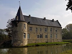
File:Cortenbach (21).JPG|Cortenbach Castle |
File:Cortenbach (21).JPG|Cortenbach Castle |
||
File:Voerendaal |
File:2016 Voerendaal, kasteel Rivieren 08.jpg|Rivieren Castle - Voerendaal |
||
</gallery> |
</gallery> |
||
Latest revision as of 15:35, 3 May 2023
Voerendaal
Voelender | |
|---|---|
 Town of Voerendaal | |
 Flag  Coat of arms | |
.svg) Location in Limburg | |
| Coordinates: 50°53′N 5°56′E / 50.883°N 5.933°E | |
| Country | Netherlands |
| Province | Limburg |
| Government | |
| • Body | Municipal council |
| • Mayor | Wil Houben (VVD) |
| Area | |
| • Total | 31.52 km2 (12.17 sq mi) |
| • Land | 31.51 km2 (12.17 sq mi) |
| • Water | 0.01 km2 (0.004 sq mi) |
| Elevation | 92 m (302 ft) |
| Population (January 2021)[4] | |
| • Total | 12,466 |
| • Density | 396/km2 (1,030/sq mi) |
| Demonym | Voerendaler |
| Time zone | UTC+1 (CET) |
| • Summer (DST) | UTC+2 (CEST) |
| Postcode | 6310–6312, 6343, 6367 |
| Area code | 045 |
| Website | www |
Voerendaal (Dutch pronunciation: [ˈvuːrə(n)daːl] ; Limburgish: Voelender) is a municipality and a town in the southeastern Netherlands.
Population centres[edit]
- Barrier
- Colmont
- Craubeek
- Dolberg
- Fromberg
- Heek
- Hellebeuk
- Klimmen
- Koulen
- Kunrade
- Mingersberg
- Opscheumer
- Overheek
- Ransdaal
- Retersbeek
- Termaar
- Termoors
- Ubachsberg
- Voerendaal
- Weustenrade
- Winthagen

Dutch topographic map of the municipality of Voerendaal, June 2015
History[edit]
The Romans left the ruins from a Roman villa rustica as a legacy. In 1049 pope Leo IX initiated the Catholic Church - Sint Laurentiuskerk. During medieval times many castles were built: Cortenbach, Haeren, Puth, Rivieren and Terworm. Also castles such as Hoenshuis and Overst Voerendaal. The area was mined for marl (mergel in Dutch) and coal.
Transportation[edit]
Railway Station:Klimmen-Ransdaal, Voerendaal
Notable people[edit]
- Roel Brouwers (born 1981) a Dutch former footballer with 289 club caps, lived in Voerendaal while playing for Borussia Monchengladbach
Gallery[edit]
-
 Church: Sint Laurentiuskerk
 -
 Monument near church
 -
 Cortenbach Castle
 -
 Rivieren Castle - Voerendaal

.JPG)
.JPG)

References[edit]
- ^ "Burgemeester en wethouders" [Mayor and aldermen] (in Dutch). Gemeente Voerendaal. Archived from the original on 6 May 2014. Retrieved 4 December 2013.
- ^ "Kerncijfers wijken en buurten 2020" [Key figures for neighbourhoods 2020]. StatLine (in Dutch). CBS. 24 July 2020. Retrieved 19 September 2020.
- ^ "Postcodetool for 6367ED". Actueel Hoogtebestand Nederland (in Dutch). Het Waterschapshuis. Retrieved 4 December 2013.
- ^ "Bevolkingsontwikkeling; regio per maand" [Population growth; regions per month]. CBS Statline (in Dutch). CBS. 1 January 2021. Retrieved 2 January 2022.
External links[edit]
 Media related to Voerendaal at Wikimedia Commons
- Official website
Places adjacent to Voerendaal | |
|---|---|

| Authority control databases: Geographic |
|---|
This Dutch Limburg location article is a stub. You can help Wikipedia by expanding it. |