
Mount Everest: Difference between revisions
m BOT - rv 203.208.88.138 (talk) to last version by Stemonitis |
No edit summary |
||
| Line 176: | Line 176: | ||
* [http://www.msnbc.msn.com/id/13001760 " 'Naked' climber on Everest sparks anger"], ''[[MSNBC]]'' |
* [http://www.msnbc.msn.com/id/13001760 " 'Naked' climber on Everest sparks anger"], ''[[MSNBC]]'' |
||
* [http://www.8000metres.com/mountains/everest/external-references/ List of Mount Everest Resources] |
* [http://www.8000metres.com/mountains/everest/external-references/ List of Mount Everest Resources] |
||
* [http://www.WayToEverest.de/ www.WayToEverest.de], An interactive fine-art panorama photobook about the way to the Everest (100p.) |
|||
== References == |
== References == |
||
<div class="references-small"> |
<div class="references-small"> |
||
Revision as of 15:25, 18 July 2006
| Mount Everest | |
|---|---|
| Highest point | |
| Elevation | 8,848.86 m (29,031.7 ft) |
| Prominence | 8,848.86 m (29,031.7 ft) |
| Isolation | 40,008 km (24,860 mi) |
Mount Everest is the point of highest elevation on Earth, measured by the height of its summit above sea level. Its summit ridge marks the border between Nepal and China.
Naming
In Nepal, the mountain is called Sagarmatha (सगरमाथा, Sanskrit for "Forehead of the Sky"); this name was invented in the early 1960s (by Baburam Acharya) when the Nepalese government realized that Mount Everest had no Nepalese name. This was because the mountain was not known and named in ethnic Nepal (the Kathmandu valley and surrounding areas). The Sherpa/Tibetan name Chomolangma was not acceptable, as it would have been against the idea of unification (Nepalization) of the country. However, the ancient name for the mountain is devgiri (in Sanskrit, it means "holy mountain") or devadurga (the English pronounced it as deodungha in the 1800s); please refer to [1] the Harrapan archaelogy site for more on the history behind the name. In Tibetan it is Chomolungma or Qomolangma (ཇོ་མོ་གླང་མ) ("Mother of the Universe"), or in Chinese: 珠穆朗瑪峰 (pinyin: Zhūmùlǎngmǎ Fēng) or 聖母峰 (Shèngmǔ Fēng).
The mountain was given its English name by Andrew Waugh, the British surveyor-general of India. With both Nepal and Tibet closed to foreign travel, he wrote:
…I was taught by my respected chief and predecessor, Colonel Sir Geo. Everest to assign to every geographical object its true local or native appellation. … But here is a mountain, most probably the highest in the world, without any local name that we can discover, whose native appellation, if it has any, will not very likely be ascertained before we are allowed to penetrate into Nepal.… In the meantime the privilege as well as the duty devolves on me to assign…a name whereby it may be known among citizens and geographers and become a household word among civilized nations.
Hence Waugh chose to name the mountain after George Everest, first using the spelling Mont Everest, and then Mount Everest. However, the modern pronunciation of Everest – IPA: [ˈɛvərɪst] or [ˈɛvərɨst] (EV-er-est) – is different from Sir George's own pronunciation of his surname, which was [ˈiv;rɪst] (EAVE-rest).
In 2002, the Chinese People's Daily newspaper published an article attacking the continued use of the English name for the mountain in the Western world, insisting that it should be referred to by its Tibetan name. Chinese marked the location Mount Qomolangma on their map more than 280 years ago, named after a Tibetans' Goddess Qomolangma, which gains ground as the peak's original name.[2]
Measurement

Radhanath Sikdar, an Indian mathematician and surveyor from Bengal, was the first to identify Everest as the world's highest peak in 1852, using trigonometric calculations based on measurements made with theodolites from 240 km (150 miles) away in India. Before it was surveyed and named, it was known as Peak XV to the survey team.
The mountain is approximately 8,848 m (29,028 feet) high, although there is some variation in the measurements. The mountain K2 comes in second at 8,611 m (28,251 feet) high. On May 22, 2005, the People's Republic of China's Everest Expedition Team ascended to the top of the mountain. After several months' complicated measurement and calculation, on October 9, 2005, the PRC's State Bureau of Surveying and Mapping officially announced the height of Everest is 8,844.43 m ± 0.21 m (29,017.16 ± 0.69 ft). They claimed it was the most accurate measurement to date.[2]. But this new height is based on the actual highest point of rock and not on the snow and ice that sits on top of that rock on the summit, so, in keeping with the practice used on Mont Blanc and Khan Tangiri Shyngy, it is not shown here. The Chinese also measured a snow/ice depth of 3.5 m,[3] which implies agreement with a net elevation of 8,848 m. But in reality the snow and ice thickness varies, making a definitive height of the snow cap, and hence the precise height attained by summiteers without sophisticated GPS, impossible to determine.
The first measurement was with theodolites in 1856. Due to lack of access to Nepal at the time, it was measured from a distance. It was found to be exactly 29,000 feet (8,839 m), but declared to be 29,002 feet (8,840 m) high. The arbitrary addition of 2 feet (0.6 m) was to avoid the impression that an exact height of 29,000 feet was nothing more than a rounded estimate.
The elevation of 8,848 m (29,028 ft) was first determined by an Indian survey in 1955, made closer to the mountain, also using theodolites. It was subsequently reaffirmed by a 1975 Chinese measurement [3]. In both cases the snow cap, not the rock head, was measured. In May 1999 an American Everest Expedition, directed by Bradford Washburn, anchored a GPS unit into the highest bedrock. A rock head elevation of 8,850 m (29,035 feet), and a snow/ice elevation 1 m (3 ft) higher, were obtained via this device [4]. Nepal, however, did not officially recognize this survey, and the discrepancy with the above mentioned 2005 Chinese survey is significantly greater than the surveys' claimed accuracy.
It is thought that the plate tectonics of the area are adding to the height and moving the summit north-eastwards. Two accounts, [5], [6] suggest the rates of change are 4 mm per year (upwards) 3-6 mm per year (northeastwards), but this account[7] mentions more lateral movement (27 mm), and even shrinkage has been mooted [8].
Everest is the mountain whose summit attains the greatest distance above sea level. Two other mountains are sometimes claimed as alternative "highest mountains on Earth". Mauna Kea in Hawaii is highest when measured from its base; it rises over 10203 m (about 6.3 mi) when measured from its base on the mid-ocean floor, but only attains 4,205 m (13,796 ft) above sea level. The summit of Chimborazo in Ecuador is 2,168 m (7,113 ft) farther from the Earth's centre (6,384.4 km or 3,967.1 mi) than that of Everest (6,382.3 km or 3,965.8 mi), because the Earth bulges at the Equator. However, Chimborazo attains a height of 6,267 m (20,561 ft) above sea level, and by this criterion it is not even the highest peak of the Andes.
The deepest spot in the ocean is deeper than Everest is high: the Challenger Deep, located in the Mariana Trench, is so deep that if Everest were to be placed into it there would be more than 2 km (1.25 mi) of water covering it.
The Mount Everest region, and the Himalayas in general, are thought to be suffering ice-melt due to global warming. The exceptionally heavy Southwest summer monsoon of 2005 is consistent with continued warming and augmented convective uplift on the Tibetan plateau to the north.
Climbing routes

Mt. Everest has two main climbing routes, the southeast ridge from Nepal and the northeast ridge from Tibet, as well as 13 other less frequently climbed routes. Of the two main routes, the southeast ridge is technically easier and is the more frequently-used route. It was the route used by Hillary and Tenzing in 1953 and the first recognised of fifteen routes to the top by 1996. This was, however, a route decision dictated more by politics than by design as the Tibetan border was closed to foreigners in 1949. Reinhold Messner (Italy) summited the mountain solo for the first time, without supplementary oxygen or support, on the more difficult Northwest route via the North Col to the North Face and the Great Couloir, on August 20th 1980. He climbed for three days entirely alone from his base camp at 6500 meters without the use of supplementary oxygen via the North Col/North Face route. This route has been noted as the 8th climbing route to the summit.
Most attempts are made during April and May before the summer monsoon season. A change in the jet stream at this time of year also reduces the average wind speeds high on the mountain. While attempts are sometimes made after the monsoons in September and October, the additional snow deposited by the monsoons makes climbing even more difficult.
Southeast ridge
The ascent via the southeast ridge begins with a trek to Base Camp at 5,380 m (17,600 ft) on the south side of Everest in Nepal. Expeditions usually fly into Lukla (2,860 m) from Kathmandu and pass through Namche Bazaar. Climbers then hike to Base Camp, which usually takes six to eight days, allowing for proper altitude acclimatization in order to prevent altitude sickness. Climbing equipment and supplies are carried by yaks, dzopkyos and porters to Base Camp on the Khumbu Glacier. When Hillary and Tenzing climbed Everest in 1953, they started from Kathmandu Valley, as there were no roads further east at that time.
Climbers will spend a couple of weeks in Base Camp, acclimatizing to the altitude. During that time, Sherpas and some expedition climbers will set up ropes and ladders in the treacherous Khumbu Icefall. Seracs, crevasses and shifting blocks of ice makes the icefall one of the most dangerous sections of the route. Many climbers and Sherpas have been killed in this section. To reduce the hazard, climbers will usually begin their ascent well before dawn. Once sunlight reaches the icefall, the danger increases substantially. Above the icefall is Camp I or Advanced Base Camp (ABC) at 6,065 m (19,900 ft).
From Camp I, climbers make their way up the Western Cwm to the base of the Lhotse face, where Camp II is established at 6,500 m (21,300 ft). The Western Cwm is a relatively flat, gently rising glacial valley, marked by huge lateral crevasses in the centre which prevent direct access to the upper reaches of the Cwm. Climbers are forced to cross on the far right near the base of Nuptse to a small passageway known as the "Nuptse corner". The Western Cwm is also called the "Valley of Silence" as the topography of the area generally cuts off wind from the climbing route. The high altitude and a clear, windless day can make the Western Cwm unbearably hot for climbers.
From Camp II, climbers ascend the Lhotse face on fixed ropes up to a small ledge at 7,470 m (24,500 ft). From there, it is another 500 metres to Camp IV on the South Col at 7,920 m (26,000 ft). From Camp III to Camp IV, climbers are faced with two additional challenges: The Geneva Spur and The Yellow Band. The Geneva Spur is an anvil shaped rib of black rock named by a 1952 Swiss expedition. Fixed ropes assist climbers in scrambling over this snow covered rock band. The Yellow Band is a section of sedimentary sandstone which also requires about 100 metres of rope for traversing it.
On the South Col, climbers enter the death zone. Climbers typically only have a maximum of two or three days they can endure at this altitude for making summit bids. Clear weather and low winds are critical factors in deciding whether to make a summit attempt. If weather does not cooperate within these short few days, climbers are forced to descend, many all the way back down to Base Camp.
From Camp IV, climbers will begin their summit push around midnight with hopes of reaching the summit (still another 1,000 metres above) within 10 to 12 hours. Climbers will first reach "The Balcony" at 8,400 m (27,700 ft), a small platform where they can rest and gaze at peaks to the south and east in the early dawn light. Continuing up the ridge, climbers are then faced with a series of imposing rock steps which usually forces them to the east into waist deep snow, a serious avalanche hazard. At 8,750 m (28,700 ft), a small table sized dome of ice and snow marks the South Summit.
From the South Summit, climbers follow the knife edge south east ridge along what is known as the "Cornice traverse" where snow clings to intermittent rock. This is the most exposed section of the climb as a misstep to the left would send one 2,400 m (8,000 ft) down the southwest face while to the immediate right is the 3,050 m (10,000 ft) Kangshung face. At the end of this traverse is an imposing 12 m (40 ft) rock wall called the "Hillary Step" at 8,760 m (28,750 ft). Hillary and Tenzing were the first climbers to ascend this step and they did it with primitive ice climbing equipment and without fixed ropes. Nowadays, climbers will ascend this step using fixed ropes previously set up by Sherpas. Once above the step, it is a comparatively easy climb to the top on moderately angled snow slopes - though the exposure on the ridge is extreme especially while traversing on very large cornices of snow. After the Hillary Step, climbers also must traverse on a very loose and rocky section that has a very large entanglement of fixed ropes that can be troublesome in bad weather. Climbers will typically spend less than a half-hour on "top of the world" as they realize the need to descend to Camp IV before darkness sets in or afternoon weather becomes a serious problem.
Northeast ridge
The northeast ridge route begins from the north side of Everest in Tibet. Expeditions trek to the Rongbuk Glacier, setting up Base Camp at 5,180 m (17,000 ft) on a gravel plain just below the glacier. To reach Camp II, climbers ascend the medial moraine of the east Rongbuk Glacier up to the base of Changtse at around 6,100 m (20,000 ft). Camp III (ABC) is situated below the North Col at 6,500 m (21,300 ft). To reach Camp IV on the north col, climbers ascend the glacier to the foot of the col where fixed ropes are used to reach the North Col at 7,010 m (23,000 ft). From the North Col, climbers ascend the rocky north ridge to set up Camp V at around 7,775 m (25,500 ft). The route goes up the north face through a series of gullies and steepens into downsloping slabby terrain before reaching the site of Camp VI at 8,230 m (27,000 ft). From Camp VI, climbers will make their final summit push. Climbers must first make their way through three rock bands known as First Step, Second Step and Third Step. Once above these steps, the final summit slopes (50 to 60 degrees) to the top.
Ascents

On June 8, 1924, George Mallory and Andrew Irvine, both of the United Kingdom, made an attempt on the summit from which they never returned. Noel Odell, the expedition's geologist, wrote in his diary that he "saw M&I on the ridge, nearing base of final pyramid" at 12:50 p.m. that day. In 1979 climber Wang Hongbao of China revealed to a companion that he had discovered a body in 1975 thought at the time to be Irvine's, but he unfortunately was killed in a fall the very next day before he could provide precise details to anyone else.
In 1999, however, the famous Mallory and Irvine Research Expedition found instead Mallory's body in the predicted search area near the old Chinese camp. Controversy has raged in the mountaineering community as to whether the duo may have made it to the top of the world, 29 years before the confirmed ascent (and of course, safe descent) of Everest by Sir Edmund Hillary and Tenzing Norgay in 1953. The general consensus among climbers has been that they did not, though recent findings may indicate otherwise. Though there is no physical evidence of either man above the Second Step, if Mallory had made it that far he likely summitted, as there are no difficult technical climbs further up. The leading theory has Mallory tackling the sheer face of the Second Step by standing on Irvine's shoulders. Armed with Irvine's spare oxygen tanks he could have summitted late in the day. Descending in darkness he may have decided to take the Norton Couloir rather than attempt down-climbing the Second Step unable to see. Almost everyone agrees Mallory died in a short fall during his descent through the couloir, where his body was found. Irvine probably briefly survived him as he awaited his companion's return, at the foot of the Second Step, but died later of exposure. Irvine's body was probably found by another Chinese climber in 1960 (nowhere near Mallory's, proving the two had separated) but has not been rediscovered since, despite several searches in 2004.
Mallory had gone on a speaking tour of the United States the year before in 1923; it was then that he exasperatedly gave the famous reply, "Because it is there," to a New York journalist in response to hearing the question, "Why climb Everest?" for seemingly the thousandth time. Comprehensive information is available at Mallory and Irvine: The Final Chapter including critical opposing viewpoints.
In 1995, George Mallory II of South Africa (grandson) reached the summit of Everest.
1933-1953
In 1933, Lady Houston, a millionaire ex-showgirl, funded the Houston Everest Flight of 1933, which saw a formation of airplanes led by the Marquess of Clydesdale fly over the summit in an effort to deploy the British Union Jack flag at the top.
After taking part in the 1935 reconnaissance expedition, the prolific mountaineering explorer Bill Tilman was appointed leader of the 1938 Everest expedition which attempted the ascent via the north west ridge. They reached over 27,000 ft (8,200 m) without supplemental oxygen before being forced down due to bad weather and sickness.
Early expeditions ascended the mountain from Tibet, via the north face. However, this access was closed to western expeditions in 1950, after the Chinese took over Tibet. However, in 1950, Bill Tilman and a small party which included Charles Houston, Oscar Houston and Betsy Cowles undertook an exploratory expedition to Everest through Nepal along the route which has now become the standard approach to Everest from the south.
Tenzing and Hillary
During 1951, a British expedition led by Eric Shipton and including Edmund Hillary, travelled into Nepal to survey a new route via the southern face.
Taking their cue from the British, in 1952 a Swiss expedition attempted to climb via the southern face, but the assault team of Raymond Lambert and Sherpa Tenzing Norgay turned back 200 meters short of the summit. The Swiss attempted another expedition in the autumn of 1952; this time a team including Lambert and Tenzing turned back at an earlier stage in the climb.
In 1953, a ninth British expedition, led by John Hunt, returned to Nepal. Hunt selected two climbing pairs to attempt to reach the summit. The first pair turned back after becoming exhausted high on the mountain. The next day, the expedition made its second and final assault on the summit with its fittest and most determined climbing pair. The summit was eventually reached at 11:30 am local time on May 29, 1953 by the New Zealander Edmund Hillary and Sherpa Tenzing Norgay from Nepal climbing the South Col Route. At the time, both acknowledged it as a team effort by the whole expedition, but after interminable pestering, Tenzing revealed a few years later that Hillary had put his foot on the summit first. They paused at the summit to take photographs and buried a few sweets and a small cross in the snow before descending. News of the expedition's success reached London on the morning of Queen Elizabeth II's coronation. Returning to Kathmandu a few days later, Hillary and Hunt discovered that they had been promptly knighted for their efforts.
1996 disaster
During the 1996 climbing season, nineteen people died trying to reach the summit, making it the deadliest single year in Everest history. May 10 of that year was the deadliest day in Everest history, when a storm stranded several climbers near the summit (on the Hillary Step), killing eight. Among those who died were experienced climbers Rob Hall and Scott Fischer, both of whom were leading paid expeditions to the summit. The disaster gained wide publicity and raised questions about the commercialization of Everest.
Journalist Jon Krakauer, on assignment from Outside magazine, was also in Hall's party, and afterwards published the bestseller Into Thin Air which related his experience. Anatoli Boukreev, a guide who felt impugned by Krakauer's book, co-authored a rebuttal book called The Climb. The dispute sparked a large debate within the climbing community. In May 2004, Kent Moore, a physicist, and John L. Semple, a surgeon, both researchers from the University of Toronto, told New Scientist magazine that an analysis of weather conditions on that day suggested that freak weather caused oxygen levels to plunge by around 14%.
During the same season, climber and filmmaker David Breashears and his team filmed the IMAX feature Everest on the mountain (some climbing scenes were later recreated for the film in BC, Canada). The 70 mm IMAX camera was specially modified to be lightweight enough to carry up the mountain, and to function in the extreme cold with the use of particular greases on the mechanical parts, plastic bearings and special batteries. Production was halted as Breashears and his team assisted the survivors of the May 10 disaster, but the team eventually reached the top on May 23 and filmed the first large format footage of the summit. On Breashears' team was Jamling Tenzing Norgay, the son of Tenzing Norgay, following in his father's footsteps for the first time.
Facts
- As of the end of the 2003 climbing season, 1,919 people had reached the summit (829 of them since 1998) and 179 people died while summitting. The conditions on the mountain are so difficult that most of the corpses have been left where they fell; some of them are easily visible from the standard climbing routes.
- Most expeditions use oxygen masks and tanks [4] above 26,000 feet (8,000 m); this region is known as the death zone. Everest can be climbed without supplementary oxygen, but this requires special fitness training and increases the risk to the climber. Humans do not think clearly with low oxygen, and the combination of severe weather, low temperatures, and steep slopes often require quick, accurate decisions.
- Mountain climbers are a significant source of tourist revenue for Nepal; they range from experienced mountaineers to relative novices who count on their paid guides to get them to the top. The Nepalese government also requires a permit from all prospective climbers; this carries a heavy fee.
Timeline
- Main article: Timeline of climbing Mount Everest
"Death zone"
- Main article: death zone
While the normal conditions for any area classified as a death zone apply for Mount Everest (altitudes higher than 8,000 meters), it is significantly more difficult for a climber to survive at the death zone on Mount Everest. Temperatures can dip to very low levels, resulting in the rapid freezing of any body part that is exposed to the air. Because the temperatures are so low, snow is well-frozen in certain areas and death by slipping and falling can also occur. High winds at these altitudes on Everest are also a potential threat to climbers.
Bottled oxygen controversy
The use of bottled oxygen to ascend Mount Everest has been extremely controversial. George Mallory himself described the use of such oxygen as unsportsmanlike, but later concluded that it would be impossible to summit without it, and consequently used it. When Tenzing and Hillary made the first successful summit in 1953, they too were using bottled oxygen. For the next twenty-five years, bottled oxygen was a standard necessity for any successful summit.
Reinhold Messner was the first climber to break the bottled oxygen tradition. In 1978, he and Peter Habeler made the first successful oxygenless climb. Although critics alleged that he sucked mini-bottles of oxygen, Messner silenced them when he summited the mountain, without oxygen or support, on the more difficult Northwest route, in 1980. In the aftermath of Messner's two successful ascents, the debate on bottled oxygen usage has ratcheted higher. Critics have made the assertion that Messner's many high-altitude sorties have resulted in real brain damage from hypoxia due to pushing himself too hard.
The aftermath of the 1996 Mount Everest disaster further intensified the debate. Jon Krakauer's Into Thin Air (1997) expressed the author's personal criticisms of the use of bottled oxgen. Krakauer wrote that the usage of bottled oxygen allowed otherwise unqualified climbers to attempt to summit, leading to dangerous situations and more deaths. The May 10 disaster was partially caused by the sheer number of climbers (33 on that day) attempting to ascend, causing bottlenecks at Hillary Step and delaying many climbers, most of whom summited after the usual 2pm turnaround time. He proposed banning bottled oxygen except for emergency cases, which would both decrease the growing trash on Everest and keep marginally qualified climbers off the mountain.
The 1996 disaster also thrust the issue of the guide's role in using bottled oxygen. Guide Anatoli Boukreev's decision not to use bottled oxygen was sharply criticized by Jon Krakauer. Boukreev's supporters (who include G. Weston DeWalt, who co-wrote The Climb) state that using bottled oxygen gives a false sense of security. Krakauer and his supporters point out that, without bottled oxygen, Boukreev was unable to directly help his clients descend. They cite that Boukreev said that he was going down with client Martin Adams, but when Adams slowed down, Boukreev went up ahead and left him behind.[5]
It should be noted that most climbers in the mountaineering community support Krakauer's point of view but the most highly experienced climbers will agree that there are a small set of climbers such as Anatoli Boukreev and Ed Viesturs who can climb without oxygen and still function well. Most climbers agree that a guide cannot directly help clients if he or she cannot concentrate or think clearly (which happens with the very thin atmosphere above).
David Sharp controversy
Double-amputee climber Mark Inglis revealed in an interview with the press on May 23, 2006 about his climb that his climbing party, and many others, had passed a distressed climber, David Sharp sheltering under a rock overhang 300 meters below the summit without attempting a rescue. The revelation sparked wide debate on climbing ethics, especially as applied to Everest.
As this debate raged, Australian climber Lincoln Hall after being declared dead, was found alive after spending the night exposed near the summit by a party of four climbers (Dan Mazur, Andrew Brash, Myles Osborne and Jangbu Sherpa) who giving up their own summit attempt, stayed with Hall and descended with him and a party of 12 sherpas sent up to carry him down. Hall later fully recovered.
Life-threatening thefts
Other climbers have reported life-threatening thefts from supply caches. Vitor Negrete, the first Brazilian to climb Everest without oxygen and part of David Sharp's party, died during his descent, and theft from his high-altitude camp may have contributed.[6]
See also
Image gallery
-
 View on the majestic Mount Everest from the Rongbuk Monastery
 -
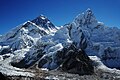 Mount Everest and Nubtse from Kala Patthar
 -
 Sagarmatha (Mount Everest) as seen from Kala Pattar


External links
- The Army On Everest, The British Army's West Ridge Expedition Site
- The Rest of Everest Video Podcast, An Almost Unabridged Expedition Experience
- Everest blogs by climbers
- Everest Interactive map
- A fundraising expedition planned for spring 2007
- EverestHistory.com, Mt. Everest timeline
- MountEverest.net
- Mount Everest Photograph
- NOVA site on Mt. Everest, Climbing pioneer history
- National Geographic's page on Mt. Everest
- The Life of Bill Tilman, leader of the 1938 Expedition on Everest
- Hiking to the base of Mt. Everest, GoNOMAD feature article
- Mount Everest Image by Roddy Mackenzie who climbed the mountain in 1989
- Mount Everest at Peakware
- Google Maps satellite image
- Panorama from the top of Mt.Everest
- Computer-generated annotated virtual panoramas North South Index, can be compared with above link
- The Hairdressers' Ascent up Mount Everest sketch from Monty Python's Flying Circus
- Very close view to the Mount Everest Basecamp with Google Earth (KMZ File)
- Xtreme Everest 2007, An expedition to study human physiology at altitude, spring 2007
- " 'Naked' climber on Everest sparks anger", MSNBC
- List of Mount Everest Resources
- www.WayToEverest.de, An interactive fine-art panorama photobook about the way to the Everest (100p.)
References
- ^ Based on elevation of snow cap, not rock head. For more details, see #measurement section.
- ^ Web Reference
- ^ abc.au article
- ^ Mountainzone article.
- ^ The debate between G. Weston DeWalt and Jon Krakauer on bottled oxygen and Boukreev's actions can be found in the Salon debates
- ^ Mounteverest.net article. See also second article.