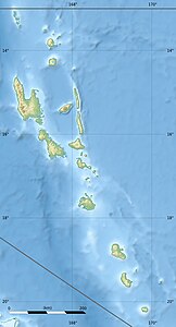
Île Ratoua
| Île Ratoua | ||
|---|---|---|
| Waters | Pacific Ocean | |
| Archipelago | Sanma | |
| Geographical location | 15 ° 37 ′ 0 ″ S , 167 ° 11 ′ 0 ″ E | |
|
|
||
| length | 1.25 km | |
| width | 750 m | |
| surface | 59 ha | |
| Highest elevation | 13 m | |
| Residents | uninhabited | |
| Ratoua I (Sulega) on the south coast of Aore | ||
Île Ratoua is a small island in the province of Sanma in the Pacific island state of Vanuatu .
geography
The Île Ratoua is located between Aore and Malo a good 50 meters south of the Port Latour settlement of Aore. It has a counterpart in the island Île Souchounlagré off the north coast of Malo. Other islands in the narrow waterway between Aore and Malo are Voïsa in the northeast and Île Wékésa in the west.
climate
Ratoua's climate is humid and tropical . The annual amount of precipitation is 3000 mm. The island is often hit by cyclones and earthquakes.
history
Vanuatu was a British - French condominium in the early 20th century . Until it became independent in 1980, the island was used as a coconut plantation for the production of copra .
Resort
In 2005, a French nature lover acquired the island and founded a resort hotel with the aim of combining sustainable use and nature conservation. The resort is designed according to an "eco-friendly" philosophy, in which natural resources are used and at the same time local people are employed to promote their prosperity.
Individual evidence
- ↑ Vanuatu . Haos Blong Volkeno. Retrieved August 8, 2018.
- ↑ Surrounding Islands . Espiritu Santo Tourism. Retrieved August 17, 2018.
- ^ UNEP Islands Directory .
- ↑ Île Ratoua at GeoNames , geonames.org 2020-05-29.
- ↑ Official homepage ratua.com 2020-05-29.
Web links
- Official homepage ratua.com

