IV. Budapest District
| IV. Budapest District (Újpest) | |||
|
|||
| Basic data | |||
|---|---|---|---|
| State : | Hungary | ||
| Region : | Central Hungary | ||
| County : | Budapest | ||
| Coordinates : | 47 ° 34 ' N , 19 ° 5' E | ||
| Area : | 18.82 km² | ||
| Residents : | 98,800 (Jan. 1, 2011) | ||
| Population density : | 5,250 inhabitants per km² | ||
| Postal code : | 1041-1048 | ||
| KSH kódja: | 05467 | ||
| Structure and administration (status: 2018) | |||
| Community type : | district | ||
| Structure : | Districts
|
||
| Mayor : | Zsolt winter coat ( Fidesz ) | ||
| Postal address : | István út 14 1041 Budapest |
||
| Website : | |||
| (Source: A Magyar Köztársaság helységnévkönyve 2011. január 1st at Központi statisztikai hivatal ) | |||
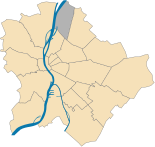
The fourth district of the Hungarian capital Budapest is also called Újpest . Another part of this district is called Újpest. The district is located on the left bank of the Danube . The name Újpest (New Pest) was chosen because the village was founded in 1840 on the border with the then independent town of Pest . Újpest was raised to an independent city in 1907 and incorporated into Budapest in 1950. Since then it has been the fourth district of the city.
The football club Újpest Budapest is named after the district in which it was founded in 1885 and is always at home. He plays in the Újpester Szusza Ferenc Stadium .
district
The district consists of six districts. The largest is Újpest, the others are Megyer , Káposztásmegyer , Istvántelek , Székesdűlő and the northern tip of the Danube island Népsziget .
Attractions
- Synagogue , built in 1885/86
Twin cities
The 4th district maintains town twinning with:
sons and daughters of the town
- Sándor Radó (1899–1981), Soviet spy
- Olivér Halassy (1909–1946), water polo player and freestyle swimmer
- Ferenc Szusza (1923-2006), football player
- Imre Hollai (1925-2017), politician
- Pál Várhidi (1931–2015), football player and coach
- György Gedó (* 1949), boxer


