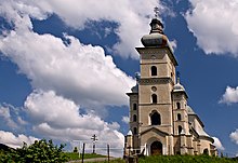
Čertižné
| Čertižné Чертiжне |
||
|---|---|---|
| coat of arms | map | |

|
|
|
| Basic data | ||
| State : | Slovakia | |
| Kraj : | Prešovský kraj | |
| Okres : | Medzilaborce | |
| Region : | Horný Zemplín | |
| Area : | 23.729 km² | |
| Residents : | 334 (Dec. 31, 2019) | |
| Population density : | 14 inhabitants per km² | |
| Height : | 459 m nm | |
| Postal code : | 067 52 ( Habura post office ) | |
| Telephone code : | 0 57 | |
| Geographic location : | 49 ° 21 ' N , 21 ° 50' E | |
| License plate : | ML | |
| Kód obce : | 520128 | |
| structure | ||
| Community type : | local community | |
| Administration (as of November 2018) | ||
| Mayor : | Peter Tričák | |
| Address: | Obecný úrad Čertižné č. 57 067 52 Habura |
|
| Website: | www.certizne.eu | |
| Statistics information on statistics.sk | ||
Čertižné (until 1927 in Slovak "Čertiažne"; in Russian Чертiжне / Tschertischne ; in Hungarian Nagycsertész - until 1907 Csertész ) is a municipality in the far east of Slovakia with 266 inhabitants (as of December 31, 2019) and belongs to the Okres Medzilaborce , a district of Prešjovský .
geography
The municipality is located in the Lower Beskids near the border with Poland at the confluence of several small streams that make up the source area of the Laborec . There is a connection to Poland via the non-navigable Čertiažské sedlo saddle on the main Carpathian ridge . The center of the village is at an altitude of 259 m nm and is eleven kilometers from Medzilaborce .
Neighboring municipalities are Habura in the southeast, Vladiča in the west and Jaśliska (PL) in the north.
history
Čertižné was first mentioned in writing in 1431 as Cherthws . For years it belonged to the Humenné estate and thus also to the Drugeth family , in the 17th century it came to the Csáky family , in the 18th century it was Szirmay and after 1863 Dobrzanski . In 1715 there was a mill and 22 households here, in 1828 there were 103 houses and 775 inhabitants who worked in the dense forests and as charcoal burners. In the last decade of the 19th century, many residents emigrated, from 1914 to 1915 the entire village was destroyed during an offensive by Russian troops.
Until 1918, the place in Semplin County belonged to the Kingdom of Hungary and then came to Czechoslovakia or now Slovakia. Together with the neighboring town of Habura, Čertižné was the site of a peasant revolt against attempted seizures. During World War II, partisans found support from the local population; on October 8, 1944, the village was liberated from the Wehrmacht by troops from the 4th Ukrainian Front .
population
According to the 2011 census, there were 375 inhabitants in Čertižné, including 240 Russians, 113 Slovaks, six Ukrainians and three Magyars and three Czechs each. Ten residents gave no information in this regard. 286 residents committed themselves to the Greek Catholic Church, 26 residents to the Orthodox Church, 21 residents to the Roman Catholic Church, four residents to the Jehovah's Witnesses and three residents to the Evangelical Church AB; one resident professed a different denomination. 22 residents had no denomination and the denomination of 12 residents was not determined.
Attractions
- Greek Catholic Church
- Memorial house to the uprising of Čertižné and Habura
- Tomb of Adolf Dobryanský
Individual evidence
- ↑ 2011 census by ethnicity (Slovak) ( Memento from October 6, 2014 in the Internet Archive )
- ↑ 2011 census by denomination (Slovak) ( Memento from September 7, 2012 in the Internet Archive )
Web links
- Unofficial website of the municipality (Slovak)
- Entry on e-obce.sk (Slovak)


