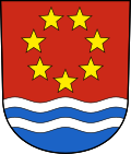
Albula / Alvra
| Albula / Alvra | |
|---|---|
| State : |
|
| Canton : |
|
| Region : | Albula |
| BFS no. : | 3542 |
| Postal code : | 7084 Brienz / Brinzauls 7450 Tiefencastel 7451 Alvaschein 7458 Mon 7459 Stierva 7472 Surava 7492 Alvaneu |
| Coordinates : | 763 249 / 170416 |
| Height : | 859 m above sea level M. |
| Height range : | 765-3096 m above sea level M. |
| Area : | 93.93 km² |
| Residents: | 1310 (December 31, 2018) |
| Population density : | 14 inhabitants per km² |
| Website: | www.albula-alvra.ch |
|
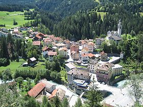
Tiefencastel |
|
| Location of the municipality | |
Albula / Alvra is a municipality in the Albula region of the Swiss canton of Graubünden .
Emergence
Albula / Alvra was created on January 1, 2015 from the merger of the previously independent municipalities of Alvaneu , Alvaschein , Brienz / Brinzauls , Mon , Stierva , Surava and Tiefencastel . The seven municipalities approved the merger agreement on February 28, 2014.
The new community has around 1370 inhabitants. The administrative headquarters are in Tiefencastel.
| Surname | Area km² | Resident December 31, 2013 |
Density per km² |
|---|---|---|---|
| Alvaneu | 35.63 | 403 | 11 |
| Alvaschein | 4.08 | 142 | 35 |
| Brienz / Brinzauls | 13.37 | 128 | 10 |
| Mon | 8.46 | 90 | 11 |
| Stierva | 10.56 | 134 | 13 |
| Surava | 6.68 | 196 | 29 |
| Tiefencastel | 14.85 | 254 | 17th |
| Total | 93.63 | 1347 | 14th |
geography
The community is located in the Albula valley . With the exception of Mon and Stierva, the villages are located in the valley floor on the cantonal road that comes from the Schin Gorge to Alvaschein and leads from Alvaneu to Bergün and Davos . Mon and Stierva are on the north-eastern slope of Piz Curver. The Julia joins the Albula at Tiefencastel . The community area extends over 9,363 hectares.
The lowest point of the municipality is in the Albula Gorge near Solis at 824 m, the highest point 200 meters northwest of Piz Mitgel at 3098 m.
Attractions
population
| Population development | |||||||
|---|---|---|---|---|---|---|---|
| year | 2010 | 2011 | 2012 | 2013 | 2014 | 2015 | 2016 |
| Residents | 1363 | 1346 | 1369 | 1347 | 1322 | 1331 | 1331 |
languages
In the last census in 2000, 64% of the inhabitants of the seven municipalities at that time stated German and 30% Romansh as their main language. Originally, the population of all seven factions spoke the Romance dialect Surmiran . In the course of the 20th century, as in all Romansh-speaking areas, the German language made its way, partly more and partly less. In the two villages of Alvaneu and Surava, Germanization took place at the beginning of the 20th century, which largely displaced Romansh. In the other villages, however, the Romance language was retained. The proportion of the Romansh-speaking population in the villages varies greatly, however. While Surava and Alvaneu according to the 2000 census Romansh shares of 11% resp. 17% speak in Stierva and Mon 66% resp. 52% Romansh.
In the municipality of Albula / Alvra, German and Romansh are equal official languages.
nationality
1147 of the residents were Swiss nationals at the end of 2015. 184 inhabitants are of foreign origin. The proportion of foreigners is therefore 13.8%.
Denominations
All seven villages in the parish are traditionally Catholic. In 2000, 1,027 people were Roman Catholics, which corresponds to a proportion of the population of 75.1%. In addition, there were 14.4% Evangelical Reformed Christians, 1.5% Muslims and 3.4% non-denominational. The rest of the population belonged to other denominations or gave no information about their creed.
literature
- Editing: Albula / Alvra. In: Historical Lexicon of Switzerland . 2016 .
Web links
- Official website of the municipality of Albula / Alvra (German, Rhaeto-Romanic)
Individual evidence
- ↑ Permanent and non-permanent resident population by year, canton, district, municipality, population type and gender (permanent resident population). In: bfs. admin.ch . Federal Statistical Office (FSO), August 31, 2019, accessed on December 22, 2019 .
- ↑ The merger in the Albula valley has succeeded In: Südostschweiz.ch . February 28, 2014, accessed March 8, 2014.
- ↑ Albula / Alvra municipal constitution approved. In: Rhätische Zeitung, article from September 18, 2014.


