Alegrete (Portalegre)
| Alegrete | ||||||
|---|---|---|---|---|---|---|
|
||||||
| Basic data | ||||||
| Region : | Alentejo | |||||
| Sub-region : | Alto Alentejo | |||||
| District : | Portalegre | |||||
| Concelho : | Portalegre | |||||
| Coordinates : | 39 ° 14 ′ N , 7 ° 19 ′ W | |||||
| Residents: | 1746 (as of June 30, 2011) | |||||
| Surface: | 86.92 km² (as of January 1, 2010) | |||||
| Population density : | 20 inhabitants per km² | |||||
| Postal code : | 7300-311 | |||||
| politics | ||||||
| Mayor : | António Maria Petas Chaparro ( PS ) | |||||
| Address of the municipal administration: | Junta de Freguesia de Alegrete Largo do Espírito Santo, 1 7300 - 311 Alegrete |
|||||
| Website: | www.alegrete.pt | |||||
Alegrete is a municipality ( freguesia ) in the Portuguese district ( concelho ) of Portalegre . 1746 inhabitants live in it (as of June 30, 2011).
history
Finds prove a settlement since the Paleolithic and especially since the Neolithic . Not much is known about the place during the Roman rule and the following Germanic tribes Vandals , Suebi and / or Visigoths in the region, because there are no written records and no extensive finds are available. It is assumed that the place was destroyed by the vandals, with the Alans repopulating it in the middle of the 5th century.
In the course of their conquest of the Iberian Peninsula from 711 , the Moors also conquered Alegrete in the early 8th century. In the course of the Reconquista , these were expelled when Portugal's first king D. Afonso Henriques conquered Alegrete in 1160 . Alegrete finally became Portuguese with the Treaty of Badajoz in 1267 . After the first reconstruction work by King D.Afonso III. His son King D Dinis built a castle here in 1319 and gave Alegrete the first city rights. In the revolution of 1383 Alegrete sided with the independence of Portugal, so that it suffered some destruction by the Castilian troops.
King Manuel I renewed the town charter in 1516 . During the War of Restoration (1640-1668) Alegrete was the scene of acts of war, and in particular suffered some destruction in 1664 , but without having been conquered.
The district of Alegrete, which has been independent since the Middle Ages, was dissolved in the course of the administrative reform in 1855 and has been a municipality of the Portalegre district ever since.
Culture and sights
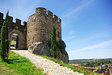
From the medieval castle, which dates back to the first fortifications in the 12th century, not all, but some parts, have been preserved. The other monuments of the community include u. a. various sacred buildings , historical public fountains and buildings and the archaeological excavation site Estação arqueológica de Porto da Boga .
In addition, the historic town center as a whole is under monument protection, as is the entire landscape section in which the municipality is located. Alegrete is located in the nature reserve of the Serra de São Mamede , hiking trails and nature trails are laid out here and lookout points (port .: Miradouros ) set up on elevations offer wide views.
administration
local community
Alegrete is the seat of a municipality of the same name ( Freguesia ). It consists of two localities:
- Alegrete
- Vale de Cavalos
Population development
| Population of Alegrete | ||
|---|---|---|
| 1821 | 1920 | 2011 |
| 1118 | 2560 | 1746 |
economy
A coffee roastery, an animal feed producer and several olive oil mills are located in the community. Due to the forestry operated here, several sawmills are also active here, as well as a building materials wholesaler, a forwarding agency and a machine trade. Some retail trade, social institutions and a few warehouses for goods logistics are also part of the local economy. The formerly important agriculture is still practiced today, but mostly only as a sideline.
Tourism only plays a subordinate role. It is operated here as individual tourism in guest houses of the Turismo rural , which are set up in historical, partly listed buildings.
Web links
- Official website
- Website of the municipality at the district ( memento of January 29, 2011 in the Internet Archive )
Individual evidence
- ↑ a b www.ine.pt - indicator resident population by place of residence and sex; Decennial in the database of the Instituto Nacional de Estatística
- ↑ Overview of code assignments from Freguesias on epp.eurostat.ec.europa.eu
- ↑ Community portrait with history on the website of the community (under A Freguesia / Apresentação ), accessed on July 28, 2013
- ↑ www.monumentos.pt , accessed on July 28, 2013
- ↑ ditto
- ↑ ditto
- ↑ ditto
- ^ Community portrait with business passage on the website of the community (under A Freguesia / Apresentação ), accessed on July 28, 2013
- ↑ www.monumentos.pt , accessed on July 28, 2013
- ↑ Tourist information on the municipal website (under Turismo e Lazer / Onde Comer / Dormir ), accessed on July 28, 2013


