Alheimer
| Alheimer | ||
|---|---|---|
|
View from Franzosenstrasse west-northwest to the Alheimer |
||
| height | 548.7 m above sea level NHN | |
| location | near Rotenburg on the Fulda ; District of Hersfeld-Rotenburg , Hessen ( Germany ) | |
| Mountains | Stölzinger Mountains | |
| Coordinates | 51 ° 2 '12 " N , 9 ° 43' 54" E | |
|
|
||
| particularities | Alheimerturm with memorial | |
The Alheimer near Rotenburg an der Fulda in Hesse Hersfeld-Rotenburg is 548.7 m above sea level. NHN is the second highest mountain in the Stölzinger Mountains after the iceberg ( 583 m ) . At its summit is the Alheimer Tower with a memorial.
geography
location
The Alheimer is located in the south of the Stölzinger Mountains. Its peak rises in the district of Rotenburg an der Fulda , around 4.5 km north of the city center. Viewed in north-south direction, the Rotenburg districts Seifertshausen , Erkshausen and Schwarzenhasel lie east of the mountain in the Haselbach valley and the Alheim districts Niedergude , Erdpenhausen and Hergershausen to the west in the Gude valley . While the landscape continues to the north in the Stölzinger Mountains, it drops along the Guttelsbach, which rises on the mountain, towards the southwest towards the Fulda .
Natural allocation
The Alheimer belongs to the natural spatial main unit group Osthessisches Bergland (No. 35), in the main unit Fulda-Werra-Bergland (357) and in the subunit Stölzinger Bergland (357.4) to the natural area Stolzhäuser Back (357.41).
geology
The summit area of the Alheimer consists of rocks from the Middle Buntsandstein , the interior of the mountain from those from the Lower Buntsandstein .
Name origin
The name of the mountain, Alheimer , could be derived from “Allmende”, an area that is used by all surrounding communities. The municipality of Alheim , which is spreading west of the mountain , was named after the land name of the highest point in the area - the Alheimer - with the Hessian municipal reform in 1972 .
According to a legend, a number of times ago lived in the landgrave's hunting lodge on the top of the mountain a group of evil robbers and day thieves. In the surrounding villages they stole everything that was not nailed down, cattle from the pastures and grain from the barns. Therefore the villagers decided to put an end to the evil and to smoke out the robbers' nest. So one day they climbed the mountain very early, armed with scythes, flails and pitchforks. However, the plan was likely betrayed. The nest was empty. Then one of the attackers shouted: “Oh, they're all home!” Since that day, the mountain has been called “Alheimer”.
Alheimerturm with memorial
The 21 m high Alheimer Tower stands on the Alheimer summit . The observation tower was built from stone from 1929 to 1930, is divided into six floors and is one of the landmarks of the Hersfeld-Rotenburg district. Its viewing platform is at a height of 20 m (around 569 m above sea level ) and can be reached via 111 steps from the mountain top, which can be climbed on foot via a somewhat difficult ascent.
From there, the eye is not only the predominantly north of Alheimers spreading Stölzinger mountains, but north to Kaufunger forest , to the north-northeast and thus east past the belonging to Stölzinger Mountains iceberg for Hohe Meissner , northeast to Brocken in Harz , according East to the Wartburg near Eisenach , to the southeast to the Thuringian Forest , to the south-southeast to the south to the Rhön , to the southwest to the Vogelsberg , to the southwest to the Knüll , to the west to the Kellerwald with the Rothaargebirge behind , to the northwest to the Habichtswälder Bergland near Kassel and to the north-northwest to the Melsunger Bergland .
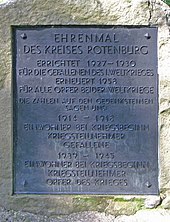
The Alheimerturm is located within a war memorial with several memorial stones for the numerous soldiers and civilian victims from the villages of the old district of Rotenburg who died in the First and Second World War . The entire complex including the observation tower is a listed building .
Traffic and walking
The federal highway 83 runs through Rotenburg an der Fulda , a little south of Alheimer . About 1.5 km northwest of the city center, in the direction of the municipality of Alheim , a spur road branches off mainly to the northeast, somewhat into the Stölzingen Mountains - with signs for Alheimer . This narrow road, leaving the Fulda valley, leads to the Alheimer car park near the Guttels farm (excursion restaurant). In addition, the main town located Rotenburger district branches from the B 83 in the east Lispenhausen the north through Schwarzenhasel and Erkshausen after Seifertshausen leading country road from the 3226th In the last-mentioned district, the first street branches off to the west to another parking lot called Alheimer . For example, the mountain can be hiked from the end of both spur roads.
Web links
- Panorama shot from the Alheimer Tower (labeling of visual targets can be activated), on panorama-photo.net
Individual evidence
- ↑ a b Map services of the Federal Agency for Nature Conservation ( information )
- ↑ DVD Tour Explorer 25 - Southern version 4.0 official topographical maps, MagicMaps, M 1: 25.000, EAN 4260160780747
- ↑ F. Schmidt-Döhl : The Hessian Bergland - The emergence of a landscape . Shaker Media, Aachen 2012, ISBN 978-3-86858-891-0 .
- ↑ Friedrich Lucae : The Noble Gem on the Hessian Crown - History of the City and the Office of Rotenburg - Rotenburg Chronicle from the Beginnings to 1700 , Vol. 1, modernized partial print of a manuscript from 1700/01, 1996, ISBN 3-925333-29- 0
- ↑ a b Photo of the board above the entrance portal of the tower, on commons.wikimedia.org
- ↑ a b Information according to measurements carried out privately (note: total height without staircase superstructure)


