
Altona-Neustädter Chaussee


The Altona-Neustädter Chaussee (also Altona-Hamburg-Neustädter Chaussee ) was one of the first artificial roads in the Duchy of Holstein ; this road led from Altona via Segeberg and Ahrensbök to Neustadt in Holstein .
The approx. 91 km long country road is after the Altona-Kieler Chaussee the longest road in Holstein, which was built according to the tried and tested method on the Makadam-Straße near Pfingstberg . Due to its branches to Eutin and Lübeck , it was (next to the roads from Lübeck to Hamburg and Altona) one of the central traffic routes in eastern Holstein .
history
Prehistory to 1842
The construction of a road between Altona and Neustadt in Holstein was made possible after an exchange of territory between the Duchy of Holstein and the Principality of Lübeck had been agreed in the Plön Agreement in 1842 , which merged the widely distributed possessions of the Principality of Lübeck into two closed areas - with the gap between the enclosed areas around Eutin and Schwartau was caused by the intended course of the road, which should only run on Holstein territory. The construction of the branches to Eutin and Lübeck was also agreed in the Plön contract .
History from 1842
The approximately 67 km long country road (nine miles - Danish miles to 7532.5 meters) was built between 1842 and 1845 by the Danish King Christian VIII , who was also Duke of Holstein in personal union . The road served to improve the land connection between Altona and Neustadt in Holstein , the second most important ( Baltic Sea ) port in Holstein after Kiel . The total distance from Altona to Neustadt was just under 13 miles (approx. 97 km).
From the Heidkrug near Kayhude - where it branched off from the Altona-Lübecker Chaussee - via Segeberg to Ahrensbök, the road was largely direct - between Ahrensbök and Neustadt in Holstein, a detour had to be made via Pönitz in order to bypass the area of the Principality of Lübeck .
From 1867 Holstein became part of the Prussian province of Schleswig-Holstein , the section of road near Ahrensbök came through the transfer of the office of Ahrensbök to the Principality of Lübeck in 1868 .
today
The remaining milestones in Süsel, Ekelsdorf, Steenrade, Flachsröste, Gnissau and Hörsten are listed as cultural monuments in the Ostholstein district:

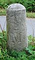
Half-milestone Ekelsdorf

Milestone (11 miles to Altona, 10.5 miles to Hamburg, 1.95 miles to Neustadt) at Steenrade
Half-milestone on Altona-Neustädter-Chaussee (near Flachsröste, across from the Ahrensbök memorial )

Milestone (10 miles to Altona, 9.5 miles to Hamburg, 2.95 miles to Neustadt) at Hörsten

Milestone (9 miles to Altona, 8.5 miles to Hamburg, 3.95 miles to Neustadt) at Wensin / Rote Kate ( Segeberg district )


The course of the Altona-Neustädter Chaussee
- From Kayhude - from junction L 82 - via Itzstedt , Leezen , Bad Segeberg and Ahrensbök to Pönitz, the federal road 432 follows today
- The L 309 follows it from Pönitz via Ekelsdorf and Süsel to Neustadt in Holstein .
Route to Eutin
The connection between the Altona-Neustädter Chaussee and Eutin was established between Eutin and the Süseler Baum (the highway money pick-up point with a turnpike ) near Süsel . The federal highway 76 follows this course today .
Route to Lübeck
The connection of the Altona-Neustädter Chaussee to Lübeck began south of Pönitz (where the Altona-Neustädter Chaussee bends towards the west) and ran via Pansdorf and Schwartau to Lübeck . Today the L 309 follows this route to the confluence with Bundesstraße 206 near Lübeck Central Station .
Others
- Numerous milestones and half-milestones along the route that is still used today ( → list ) testify to the course of the Altona-Neustädter Chaussee .

Street signs "Neustädter Chaussee" / "Segeberger Chaussee" in Ahrensbök

Chaussee between Ahrensbök and Pönitz

- The place names " Süseler Baum " and " Borsteler Baum " can be traced back to former highway cash levers or their barriers . The street names "Segeberger Chaussee" (several times in Hamburg and Schleswig-Holstein) and "Neustädter Chaussee" (near Ahrensbök) are reminiscent of the Chaussee.
swell
Web links
- Information (PDF; 1.8 MB) on the construction of the highway between 1830 and 1880 at www.schleswig-holstein.de
- Süseler Baum - from the Chausseegeldhebestelle to the traffic junction ( Memento from June 9, 2008 in the Internet Archive )
- Holstein (1820-1866) (section " Traffic ") on www.hgis-germany.de
- List of cultural monuments in Ostholstein (monument protection of the milestones of the Altona-Neustädter-Chaussee)
literature
- Jürgen Vogler: Ostholstein yesterday. Heide 2007, in it: "Dänenchaussee - A street with history"
- Johannes Hugo Koch: Heimatbuch Neustadt in Holstein. Neustadt in Holstein 1967
Coordinates: 54 ° 4 ′ 51.6 ″ N , 10 ° 41 ′ 47.4 ″ E