Ashikaga
| Ashikaga-shi 足 利市 |
||
|---|---|---|
| Geographical location in Japan | ||
|
|
||
| Region : | Kanto | |
| Prefecture : | Tochigi | |
| Coordinates : | 36 ° 20 ' N , 139 ° 27' E | |
| Basic data | ||
| Surface: | 177.82 km² | |
| Residents : | 144,684 (October 1, 2019) |
|
| Population density : | 814 inhabitants per km² | |
| Community key : | 09202-9 | |
| Symbols | ||
| Flag / coat of arms: | ||
| Tree : | maple | |
| Flower : | azalea | |
| town hall | ||
| Address : |
Ashikaga City Hall 3 - 2145 , Honjo Ashikaga -shi Tochigi 326-8601 |
|
| Website URL: | http://www.city.ashikaga.tochigi.jp/ | |
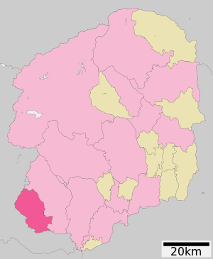
| Location of Ashikagas in Tochigi Prefecture | ||
Ashikaga ( Jap. 足利市 , - shi ) is a city of the prefecture of Tochigi inland from Honshu main island of Japan .
geography
Ashikaga is located about 60 km north of Tokyo in the Kantō plain on the river Watarase , which crosses the city from west to east.
history
Ashikaga was a center for Chinese culture and Confucianism . The Ashikaga school there had its heyday in the Muromachi period . The library with its rich Chinese and Japanese literature has been preserved .
In the Edo period , Ashikaga was the seat of a branch line of the Toda , who lived there in a permanent house (陣 屋, jinja) with an income of 11,000 koku . In 1921 Ashikaga was promoted to city.
traffic
- Street
- train
- JR Ryōmō Line to Takasaki or Oyama
- Tōbu Isesaki Line to Asakusa or Isesaki
economy
Economic factors are silk processing , cotton trade and the synthetic fiber industry .
sons and daughters of the town
- Aida Mitsuo (1924–1991), poet and calligrapher
- Fumio Itabashi (* 1949), jazz pianist
- Toshimitsu Motegi (* 1955), politician
- Takao Kobayashi (* 1961), amateur astronomer
- Hisao Mita (* 1991), soccer player
Neighboring cities and communities
- Tochigi prefecture
- Gunma Prefecture
Twin cities
-
 Jining , People's Republic of China , since 1989
 -
 Springfield , Illinois , since 1990
Web links
Commons : Ashikaga - collection of images, videos and audio files


