
Aufseß (river)
| Aufseß | ||
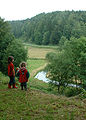
 The middle Aufseßal |
||
| Data | ||
| Water code | DE : 24264 | |
| location |
Franconian Alb
|
|
| River system | Rhine | |
| Drain over | Wiesent → Regnitz → Main → Rhine → North Sea | |
| source | at Königsfeld 49 ° 56 ′ 40 ″ N , 11 ° 9 ′ 36 ″ E |
|
| Source height | approx. 450 m above sea level NN | |
| muzzle | between Waischenfeld and Gößweinstein in the Wiesent Coordinates: 49 ° 48 ′ 39 ″ N , 11 ° 17 ′ 49 ″ E 49 ° 48 ′ 39 ″ N , 11 ° 17 ′ 49 ″ E |
|
| Mouth height | approx. 335 m above sea level NN | |
| Height difference | approx. 115 m | |
| Bottom slope | approx. 3.9 ‰ | |
| length | 29.6 km | |
| Catchment area | 97.29 km² | |
The Aufseß is a 30 km long right tributary of the Wiesent in Franconian Switzerland .
geography
Aufseßquelle

The Aufseßquelle is located on the western outskirts of Königsfeld . It is a karst spring that has been designated as a natural monument. A wayside shrine at the spring commemorates the murder of the then pastor Funk in 1632. Over the Easter holidays , the Aufseß spring is decorated as an Easter fountain.
course
The Aufseß flows mainly to the southeast in a valley that is increasingly deeper into the plateau of the Franconian Alb and flows into the Wiesent from the right at Doos .
Tributaries
There are no longer tributaries flowing into the Aufseß. However, it receives inflows from crevice and groundwater inflows as well as some karst springs along the river.
Places along the Aufseß
- Königsfeld , district of Königsfeld
- Kotzendorf , district of Königsfeld
- Voitmannsdorf , district of Königsfeld
- Drosendorf an der Aufseß , district of Hollfeld
- Sachsendorf , district of Aufseß
- Neuhaus , district of Aufseß
- Oberaufseß , district of Aufseß
- Aufseß
- Draisendorf , district of Wiesenttal
- Wüstenstein , district of Wiesenttal
- Cake mill , district of Wiesenttal
- Doos , district of Waischenfeld
Character and environment
The Aufseß flows in the middle of the Franconian Switzerland-Veldenstein Forest Nature Park . There is no road in the Aufseß valley between Wüstenstein and Doos, which makes the approximately six kilometer long valley area suitable for hiking. The Aufseßal hiking trail is a section of the Main-Danube trail (Jura line). The small river that flows into the Wiesent and bears the same name as the old Franconian noble family of this area is a limestone brook that is still very natural in the trout region.
In the village of Aufseß you can still cross the Aufseß by means of a ford . At its confluence with the Wiesent, the Aufseß formed the Doos , once the mightiest waterfall in Franconia, on an approximately three-meter-high tufa barrier that was dismantled around 1850 .
Picture gallery

Aufseß near the source

Aufseß in Koenigsfeld

Aufseßal near Aufseß

Aufseßal near Aufseß
Aufseßal near Aufseß

Ford in Aufseß

Bridge to Unteraufseß Castle


See also
literature
- Johann Kaspar Bundschuh : Aufsees, (the) . In: Geographical Statistical-Topographical Lexicon of Franconia . tape 1 : A-egg . Verlag der Stettinische Buchhandlung, Ulm 1799, DNB 790364298 , OCLC 833753073 , Sp. 198 ( digitized version ).
Web links
- Course of the Aufseß on the BayernAtlas
Individual evidence
- ↑ a b Directory of stream and river areas in Bavaria - Main river area, page 55 of the Bavarian State Office for the Environment, as of 2016 (PDF; 3.3 MB)