
St. Gallen – Winterthur railway line
| St. Gallen – Winterthur | |||||||||||||||||||||||||||||||||||||||||||||||||||||||||||||||||||||||||||||||||||||||||||||||||||||||||||||||||||||||||||||||||||||||||||||||||||||||||||||||||||||||||||||||||||||
|---|---|---|---|---|---|---|---|---|---|---|---|---|---|---|---|---|---|---|---|---|---|---|---|---|---|---|---|---|---|---|---|---|---|---|---|---|---|---|---|---|---|---|---|---|---|---|---|---|---|---|---|---|---|---|---|---|---|---|---|---|---|---|---|---|---|---|---|---|---|---|---|---|---|---|---|---|---|---|---|---|---|---|---|---|---|---|---|---|---|---|---|---|---|---|---|---|---|---|---|---|---|---|---|---|---|---|---|---|---|---|---|---|---|---|---|---|---|---|---|---|---|---|---|---|---|---|---|---|---|---|---|---|---|---|---|---|---|---|---|---|---|---|---|---|---|---|---|---|---|---|---|---|---|---|---|---|---|---|---|---|---|---|---|---|---|---|---|---|---|---|---|---|---|---|---|---|---|---|---|---|---|
 | |||||||||||||||||||||||||||||||||||||||||||||||||||||||||||||||||||||||||||||||||||||||||||||||||||||||||||||||||||||||||||||||||||||||||||||||||||||||||||||||||||||||||||||||||||||
| Timetable field : | 850 | ||||||||||||||||||||||||||||||||||||||||||||||||||||||||||||||||||||||||||||||||||||||||||||||||||||||||||||||||||||||||||||||||||||||||||||||||||||||||||||||||||||||||||||||||||||
| Route length: | 57.1 km | ||||||||||||||||||||||||||||||||||||||||||||||||||||||||||||||||||||||||||||||||||||||||||||||||||||||||||||||||||||||||||||||||||||||||||||||||||||||||||||||||||||||||||||||||||||
| Gauge : | 1435 mm ( standard gauge ) | ||||||||||||||||||||||||||||||||||||||||||||||||||||||||||||||||||||||||||||||||||||||||||||||||||||||||||||||||||||||||||||||||||||||||||||||||||||||||||||||||||||||||||||||||||||
| Power system : | 15 kV 16.7 Hz ~ | ||||||||||||||||||||||||||||||||||||||||||||||||||||||||||||||||||||||||||||||||||||||||||||||||||||||||||||||||||||||||||||||||||||||||||||||||||||||||||||||||||||||||||||||||||||
| Maximum slope : | 16 ‰ | ||||||||||||||||||||||||||||||||||||||||||||||||||||||||||||||||||||||||||||||||||||||||||||||||||||||||||||||||||||||||||||||||||||||||||||||||||||||||||||||||||||||||||||||||||||
|
|||||||||||||||||||||||||||||||||||||||||||||||||||||||||||||||||||||||||||||||||||||||||||||||||||||||||||||||||||||||||||||||||||||||||||||||||||||||||||||||||||||||||||||||||||||
The St. Gallen – Winterthur railway is a standard-gauge railway in the Swiss cantons of St. Gallen , Thurgau and Zurich and belongs to the Swiss Federal Railways (SBB). The 57.1 kilometer route was opened in four stages by the Sankt Gallisch-Appenzellische Eisenbahn (SGAE) between 1855 and 1856 .
history
Construction and opening

The canton of Thurgau initially wanted to refuse the concession on its territory because the route would not have favored Thurgau. One report said: “ The problems with Thurgau, which delay the collaudation of the route between Rickenbach and Aadorf without sufficient reasons, are essentially to blame that the test drives on the St.Galler-Appenzeller-Bahn between Winterthur and Wyl only happened after 10 Days can begin. "It becomes clear on September 27, 1855:" ... the St. Gallen locomotive arrived in Wyl and was greeted with gunfire. It is of the newest, very beautiful construction and essentially different from those of the northeast railway . »The Swiss Northeast Railway operated the competing route Winterthur – Frauenfeld – Romanshorn , which ran through Thurgau .
The section Winterthur Wil - Thur bridge Schwarzenbach was led by Julius heart built. The Winterthur – Wil section was opened on October 14, 1855. At that time the journey time was 40 minutes.
The route between Wil and Flawil was hotly debated. The SGAE applied for the concession for the easily traceable route from Schwarzenbach south of Uzwil's local mountain Vogelsberg via Bettenauer Weiher and Oberuzwil to Flawil. With a view to industry, a route north of the Vogelsberg was preferred so that Uzwil could get a train station. A tight S-curve had to be created on the edge of the Vogelsberg, where the later Uzwil train station would be. As a result, this S-curve is now one of the slowest sections of the entire route and the narrowest curve in high-speed traffic in Switzerland. On December 25, 1855, the Wil – Flawil section was inaugurated.
From January 14, 1854 to February 10, 1856 the steel truss bridge was built over the Glatt near Burgau between Flawil and Gossau SG . On February 15, 1856 Gossau and Winkeln were reached. On March 24, 1856, the line was finally extended to the city of St. Gallen. For this purpose, the iron lattice bridge designed by Karl Etzel was built over the Sitter, the first Sitter Viaduct .
Further development

On December 31, 1879, a train coming from Winterthur derailed in Vonwil near St. Gallen . The two locomotives came to rest to the left and right of the railroad track, the cars pushed into one another. The accident claimed two lives and several, some seriously injured.
→ Main article: Railway accident in Vonwil
When the railways were nationalized on July 1, 1902, the line became part of the Swiss Federal Railways. Starting in 1903, the SBB gradually expanded the line to double-track it and electrified it in 1927 with 15,000 volts 16. Hz. At the same time, the Algetshausen-Henau stop was inaugurated and the Bühler brothers' industrial railway in Uzwil was put into operation. In the course of the expansion of the double lane, the Sitter Viaduct and the Glattbrücke near Burgau were rebuilt in 1924/1925. The stone arch bridge over the Glatt with a total height of 30 meters and a length of 102 meters was replaced in 1997 by another new building. Thanks to a newly attached footbridge for bicycles and pedestrians, the path from Gossau to Flawil became level and the detour via the military footbridge built by Field Division 7 in 1988 was no longer necessary .
In December 2006, the Winterthur Hegi stop was opened as part of the third expansion phase of the Zurich S-Bahn . In 2013 the Algetshausen-Henau stop and the Schwarzenbach SG train station were closed.
business
In long-distance traffic, the line is part of the east-west axis St. Gallen – Geneva. In regional traffic, the Rheintal-Express (REX) runs on the St. Gallen section from Chur via St. Gallen to Wil. In local traffic, the route is used by the S 1 (St. Gallen – Wil), the S 11 (St. Gallen – Wil) reinforcement line and the S 5 (St. Gallen – Gossau– Weinfelden ) of the St. Gallen S-Bahn . The section west of Wil is served by the S 35 Winterthur – Wil line of the Zurich S-Bahn .
The route will be served by the following lines in 2017/18:
- Long-distance transport
-
 ( Basel SBB - Aarau -) Zurich HB - St. Gallen - Memmingen / Kempten - Munich
-
 1 Genève-Aéroport - Bern - Zurich HB - St. Gallen
-
5 Genève-Aéroport / Lausanne - Biel / Bienne - Zurich HB (- St. Gallen )
-
 13 Zurich HB - St. Gallen - Chur partially
-
 37 Basel SBB - Aarau - Zurich HB (- St. Gallen )
- Regional traffic
-
 Winterthur - St. Gallen (night line)
- S-Bahn St. Gallen
- S 1 Wil - St. Gallen
- S 5 St. Gallen - Gossau - Weinfelden
- S 11 Wil - St. Gallen ( repeater line during rush hour )
- Zurich S-Bahn
- S 35 Winterthur - Wil
photos

Stress test of the Sitter Viaduct shortly before the start of electrical operation

Aerial view of Wil train station with the distinctive silo from 1963
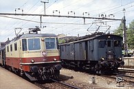
In the 1970s and 1980s, the Re 4/4 II (left in the picture with TEE paint) shaped the company. On the right is a De 4/4 that runs between Sulgen and St. Gallen .

S-Bahn from Thurbo on the Sitter Viaduct near St. Gallen Bruggen

A retaining S 35 in Guntershausen , in the background Alpsteingebirge with Santis

Re 460 with an IC2000 at Schottikon

.jpg)


literature
- Anton Heer: Rorschach-St.Gallen-Winterthur: between 170 years of railway history and the future . Sabon-Verlag, St. Gallen 2006, ISBN 3-907928-55-5 . ( PDF; 14.2 MB )
- Hans G. Wägli: Swiss Rail Network . AS Verlag, Zurich 1998, ISBN 3-905111-21-7 .
- Hans G. Wägli: Railway Profile Switzerland 2005. Diplory Verlag, Grafenried 2004, DNB 972778233 .
Individual evidence
- ^ Anton Heer: Rorschach-St.Gallen-Winterthur: between 170 years of railway history and the future . Contains detailed registers of sources and persons
- ↑ The tightest curve in the rail network. In: Homepage of the community of Uzwil. Retrieved May 15, 2017 .