
Stollberg – St. Egidien
| Stollberg (Sachs) - St. Egidien | |||||||||||||||||||||||||||||||||||||||||||||||||||||||||||||||||||||||||||||||||||||||||||||||||||||||||||||||||||||||||||||||||||||||||||||||||||||||||||||||||||||||||||||||||||||||||||||
|---|---|---|---|---|---|---|---|---|---|---|---|---|---|---|---|---|---|---|---|---|---|---|---|---|---|---|---|---|---|---|---|---|---|---|---|---|---|---|---|---|---|---|---|---|---|---|---|---|---|---|---|---|---|---|---|---|---|---|---|---|---|---|---|---|---|---|---|---|---|---|---|---|---|---|---|---|---|---|---|---|---|---|---|---|---|---|---|---|---|---|---|---|---|---|---|---|---|---|---|---|---|---|---|---|---|---|---|---|---|---|---|---|---|---|---|---|---|---|---|---|---|---|---|---|---|---|---|---|---|---|---|---|---|---|---|---|---|---|---|---|---|---|---|---|---|---|---|---|---|---|---|---|---|---|---|---|---|---|---|---|---|---|---|---|---|---|---|---|---|---|---|---|---|---|---|---|---|---|---|---|---|---|---|---|---|---|---|---|---|
 Section of the route map of Saxony from 1902
| |||||||||||||||||||||||||||||||||||||||||||||||||||||||||||||||||||||||||||||||||||||||||||||||||||||||||||||||||||||||||||||||||||||||||||||||||||||||||||||||||||||||||||||||||||||||||||||
| Route number : | 6641; sä. StE | ||||||||||||||||||||||||||||||||||||||||||||||||||||||||||||||||||||||||||||||||||||||||||||||||||||||||||||||||||||||||||||||||||||||||||||||||||||||||||||||||||||||||||||||||||||||||||||
| Course book section (DB) : | 523 | ||||||||||||||||||||||||||||||||||||||||||||||||||||||||||||||||||||||||||||||||||||||||||||||||||||||||||||||||||||||||||||||||||||||||||||||||||||||||||||||||||||||||||||||||||||||||||||
| Route length: | 19.455 km | ||||||||||||||||||||||||||||||||||||||||||||||||||||||||||||||||||||||||||||||||||||||||||||||||||||||||||||||||||||||||||||||||||||||||||||||||||||||||||||||||||||||||||||||||||||||||||||
| Gauge : | 1435 mm ( standard gauge ) | ||||||||||||||||||||||||||||||||||||||||||||||||||||||||||||||||||||||||||||||||||||||||||||||||||||||||||||||||||||||||||||||||||||||||||||||||||||||||||||||||||||||||||||||||||||||||||||
| Maximum slope : | 19 ‰ | ||||||||||||||||||||||||||||||||||||||||||||||||||||||||||||||||||||||||||||||||||||||||||||||||||||||||||||||||||||||||||||||||||||||||||||||||||||||||||||||||||||||||||||||||||||||||||||
| Minimum radius : | 291 m | ||||||||||||||||||||||||||||||||||||||||||||||||||||||||||||||||||||||||||||||||||||||||||||||||||||||||||||||||||||||||||||||||||||||||||||||||||||||||||||||||||||||||||||||||||||||||||||
| Top speed: | 80 km / h | ||||||||||||||||||||||||||||||||||||||||||||||||||||||||||||||||||||||||||||||||||||||||||||||||||||||||||||||||||||||||||||||||||||||||||||||||||||||||||||||||||||||||||||||||||||||||||||
|
|||||||||||||||||||||||||||||||||||||||||||||||||||||||||||||||||||||||||||||||||||||||||||||||||||||||||||||||||||||||||||||||||||||||||||||||||||||||||||||||||||||||||||||||||||||||||||||
The Stollberg – St. Egidien is a branch line in Saxony . The main purpose of the route construction at the time was the removal of the coal mined in the Lugau-Oelsnitz district . The route runs from Stollberg via Oelsnitz to St. Egidien on the Dresden – Werdau main line .
history


.JPG)
The first projects for a railway from St. Egidien to Stollberg were discussed as early as 1870. A similar project also envisaged a railway from Hohenstein to Oelsnitz. It was not until the session in 1875/76 that the Saxon state parliament approved the construction of a railway from St. Egidien via Oelsnitz to Stollberg. The construction of a branch line to the Konkordia and Kaisergrube shafts and a short connecting line to the Chemnitz-Würschnitzer railway to Lugau was also approved .
Construction work on the line began in April 1877. At Niederwürschnitz, Oelsnitz, Lichtenstein and St. Egidien it was necessary to build larger viaducts. On October 15, 1878, goods traffic could be started on a provisional basis; From May 15, 1879, passenger trains started running.
Around 1912 there were direct branch tracks to the Merkur and Pluto shafts in Gersdorf , Ida , Helene and United-Feld in Hohndorf and Germany and Verein-Glück in Oelsnitz. The Hedwig , Concordia , Frieden and Kaisergrube shafts were connected via the Oelsnitz – Kaisergrube branch line .
The subsidence caused by the mining caused enormous problems. At the beginning of the 1950s, for example, the Hegebachtal viaduct suffered from vaulting, which could ultimately only be repaired by concreting the arches. Between Neuoelsnitz and Oelsnitz the surface of the earth had sunk by up to 17 meters (!) In places. In this area, the gradient of the route was massively disturbed in some sections. The Neuoelsnitz train station therefore had to be completely re-leveled after mining was discontinued after 1971.
As a result of the political change in eastern Germany in 1989/90, there was a noticeable decline in travel and freight traffic. In the 1990s, the closure of the line was discussed several times because of the low traffic volume. In the end, the Central Saxony Transport Association, founded in November 1997, decided to continue operations.
In February 2002 the route was leased by the Regio Infra Service Sachsen (RISS) from kilometers 1.375 to 19.461 from DB Netz. As a result, the line was extensively modernized, which in addition to the renewal of the tracks also included the renovation of the four large viaducts. In addition, a total of five new stops were set up in Stollberg, Oelsnitz and Lichtenstein in advance of the Chemnitz model . Since then, the route has been controlled centrally in Stollberg, and all other signal boxes have been closed. Up to kilometer 1.375, the line has been leased by City-Bahn Chemnitz as part of Stollberg station . City-Bahn Chemnitz has transferred the operational management itself to the RISS in analogy to the adjoining section Stollberg – Abzw Zwönitzbrücke .
On February 15, 2003 the scheduled passenger train service with modern low-floor railcars of the City-Bahn Chemnitz was resumed. Since then, trains have been running every hour on weekdays. The trains were i. d. R. to Glauchau , occasionally even to Meerane . As a result of the reduced allocation of funds by the Free State of Saxony, the responsible Zweckverband Verkehrsverbund Mittelachsen has only been able to finance a reduced number of journeys since the timetable change in mid-December 2011. On weekdays an approximate hourly service is still offered, but only 4 pairs of trains run via St. Egidien to Glauchau (and this also not during the summer holidays). On Saturdays, Sundays and public holidays there is a two-hour cycle between Stollberg and St. Egidien. From February 24, 2020, the city train from Stollberg will run every hour on weekdays to Glauchau, where there is a connection to trains in the direction of Zwickau, Chemnitz / Dresden and Gößnitz.
Today only the Lichtenstein industrial park is used for goods traffic.
outlook
Stage 5 of the Chemnitz model is intended to extend the Stollberg – St. To integrate Egidien into the Stollberg (Sachs) station by means of an approx. 3.5 km long new line from Niederwürschnitz to the south, to electrify it with 750 V direct current between the future Niederwürschnitz junction and the Oelsnitz / Erzgeb station and to create a new Mitteloelsnitz stop. As a result, line C11 is to be extended every 30 minutes via Stollberg to Oelsnitz. This will enable journeys between Oelsnitz, Niederwürschnitz and downtown Chemnitz without changing trains. The traffic commissioning was originally planned for the end of 2021. According to a media report from June 2018, the commissioning of the line electrification and the adjacent new line was no longer expected before 2022. According to undated information from May 2020, the draft planning had to be revised "with regard to the future electric vehicle concept". The plan approval procedure should now be initiated in 2020. Depending on its progress, the two-year main construction period (including the new line) should be in 2023 and 2024. At the same time, it will be checked whether level 5 of the Chemnitz model can be extended to St. Egidien. The start of the route electrification and the start of the condensed operating program are not expected before the end of 2024.
On June 26, 2020, the Verkehrsverbund Mittelachsen announced that the entire route from Stollberg to St. Egidien should now be electrified as part of the Chemnitz model. The planned line C11 is to be carried out electrically beyond Oelsnitz (Erzgeb), electric two-system vehicles are to be used that can be operated with both 750 V direct voltage and 15 kV alternating voltage. The end-to-end electrification should go into operation in 2025. Since the tracks of the St. Egidien train station are already electrified with 15 kV alternating voltage, but the route from Chemnitz to Stollberg with 750 V direct voltage, a system separation point is required between Stollberg and St. Egidien . So far there is no information about their planned location.
Operating points
Stollberg (Sachs) ⊙
The Stollberg (Sachs) station was opened on October 15, 1878 as the starting point for the Stollberg – St. Egidien opened. Since 1889 it was the crossing point with the Zwönitz – Chemnitz Süd railway line . With the suspension of rail traffic to Zwönitz, Stollberg (Sachs) station has been the end and starting point of two railway lines since 1967. With the introduction of the Chemnitz model , diesel-powered trains of the Chemnitz City Railway now run to St. Egidien and electric trains to Chemnitz.

Reception building of the Stollberg (Sachs) train station, 2016
Stollberg (Sachs) station with City-Bahn to Chemnitz, 2016

City rail car to Chemnitz leaving Stollberg (Sachs) station, 2016
_Gleisansicht.JPG)
_mit_Citybahn.JPG)
.JPG)
Stollberg Schlachthofstrasse ⊙
The Stollberg Schlachthofstrasse stop was opened with the introduction of the Chemnitz model on December 15, 2002. It has two outer platforms, one each on the single-track lines to Chemnitz and St. Egidien, which run parallel here. The trains to and from Chemnitz stop on the electrified track, the trains to and from St. Egidien on the non-electrified track. The stop has a modern bus shelter per platform.

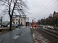
Stollberg-Schlachthofstraße stop (2016)

Stollberg-Schlachthofstraße stop (2016)

Signpost at the Stollberg-Schlachthofstraße stop (2016)
.JPG)
.JPG)

Niederwürschnitz ⊙

The Niederwürschnitz stop was opened on December 9, 1895. He has a platform in the direction of St. Egidien with a modern bus shelter. The stop is located in the south of the village directly on the federal highway 180 .
Neuoelsnitz ⊙
The Neuoelsnitz station was opened on 15 October 1878 as loading point. It was opened as a stop for passenger traffic on May 15, 1879 together with passenger traffic on the Stollberg – St. Egidien and Neuoelsnitz – Wüstenbrand . The six-track stop equipped with two platforms and converted into a train station in 1905 had the following names:
- until April 30, 1906 cave pond
- May 1, 1906 to October 4, 1930 Neuölsnitz
- from October 5, 1930: Neuoelsnitz
It was converted into a breakpoint with a branch in 1979 . In 1989/90 the passenger traffic was stopped after the desert fire on August 10, 1990. The station building, which had been closed since 1988 due to mountain damage, was finally demolished in August 1993. On September 27, 1996, the rest of the goods traffic to Lugau was discontinued, so that only the unoccupied Neuoelsnitz stop remained. In the course of taking over the Stollberg – St. Egidien by Regio Infra Service Sachsen the platform was relocated in 2002/03 by approx. 200 m in the direction of Mitteloelsnitz in order to offer travelers a shorter route to the Oelsnitz district of Neuoelsnitz. Apart from signal box 2, nothing has been preserved from the original buildings .

Neuölsnitz station around 1910

Neuoelsnitz station, original location (2009)

Current platform (2016)
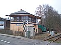
Signal box 2 at the Neuoelsnitz level crossing (2016)


Mitteloelsnitz ⊙
.JPG)
The Mitteloelsnitz stop was opened on May 1, 1904. The original location was at km 7.59 on Stadionstrasse. In the course of the rehabilitation of the route, it was relocated to kilometer 6.99 and provided with a modern bus shelter. The new stop is on Innere Neuwieser Straße. There is a parking lot and a bus stop in the immediate vicinity.
With the realization of stage 5 of the Chemnitz model, another stopping point is to be created in the area of the old train station.
Oelsnitz Bahnhofstrasse ⊙

The Oelsnitz Bahnhofstrasse stop was only set up in the course of the route renovation on February 15, 2003. The stop in the center of Oelsnitz can be reached via Bahnhofstrasse and is equipped with a modern bus shelter. There is a supermarket in the immediate vicinity.
Oelsnitz (Ore Mountains) ⊙
The station Oelsnitz (Erzgeb) is the most important station of the route. It was opened on October 15, 1878 and had the following names:
- until 1889: Oelsnitz near Lichtenstein
- until 1904: Oelsnitz i Erzgeb
- until 1905: Ölsnitz i Erzgeb train station
- until 1911: Ölsnitz i Erzgeb
- until 1930: Ölsnitz (Erzgeb)
- since 1930: Oelsnitz (Erzgeb)
The station gained great importance in connection with the coal mining in the Lugau-Oelsnitz coal field . In the vicinity of the station, some tracks branched off to shafts. The trains on the Wüstenbrand-Neuoelsnitz railway usually ended at Oelsnitz (Erzgeb) station.
In 2015, the Saxon State Garden Show took place on the disused part of the station . As a result, the reception building was also renovated. The 15 hectare site of the show will be retained as a multi-use leisure park. With generously laid out plantations, sunbathing lawns, railway and water playground, skate park , nature trail , Kneipp facility and graduation tower , it is intended to serve as a leisure and recreation area in the future. In the entrance to the park, on the station forecourt, there is the “Black Gold” fountain , which reminds of the coal mining in the area and refers to the future use of brine.

Oelsnitz (Erzgeb) train station before renovation (2012)
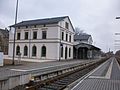
refurbished Oelsnitz (Erzgeb) station, railway side (2016)

renovated Oelsnitz (Erzgeb) station, street side (2016)
Oelsnitz (Erzgeb) train station, rail express of the State Horticultural Show 2015

Oelsnitz (Erzgeb) station, renatured station area for the 2015 State Horticultural Show

.JPG)
.JPG)
.JPG)
.JPG)
Hohndorf middle ⊙
The Hohndorf Mitte stop was only set up in the course of the route renovation on February 15, 2003. The stop in the center of Hohndorf can be reached via Untere Angerstraße. Before the opening of the stop, the citizens of Hohndorf could board either at the Oelsnitz (Erzgeb) train station or at the next stop in Rödlitz-Hohndorf. The Hohndorf Mitte stop has a modern bus shelter.
Rödlitz-Hohndorf ⊙
The Rödlitz-Hohndorf stop was established on January 10, 1891. Until 1930 it was only called Rödlitz . The stop is in the north-west of Rödlitz not far from the Rödlitzer Viaduct and the local border with Hohndorf. It can be reached from Bahnhofstrasse and has a modern bus shelter.
Lichtenstein Hartensteiner Strasse ⊙
The Lichtenstein Hartensteiner Strasse stop was only set up in the course of the route renovation on February 15, 2003. It is located in the south of the city of Lichtenstein near the local hospital and can be reached via Hartensteiner Straße. The breakpoint has a modern bus shelter.

Hohndorf Mitte stop (2016)

Rödlitz-Hohndorf stop (2016)

Lichtenstein-Hartensteiner Strasse stop (2016)
.JPG)


Lichtenstein (Sachs) ⊙
.JPG)
Lichtenstein (Sachs) train station was opened on October 15, 1878. Until 1938 it was called Lichtenstein-Callnberg . The stately station building is unused.
Lichtenstein Ernst Schneller Estate ⊙
The Lichtenstein Ernst-Schneller-Siedlung stop was only set up in the course of the line renovation on February 15, 2003. It is located in the north of the city of Lichtenstein and can be reached via the settlement of the same name or Glauchauer Strasse. The breakpoint has a modern bus shelter.
Lichtenstein industrial area ⊙
The Lichtenstein industrial area stop was only set up in the course of the route renovation on February 15, 2003. It is already located in the district of St. Egidien and serves to connect the Lichtenstein industrial park. In addition to the through track, the stop also has three freight tracks. The Auersberg-Center shopping center is not far from the stop . The breakpoint has a modern bus shelter.

Lichtenstein stop Ernst Schneller settlement (2016)

Lichtenstein industrial area stop on the corridor of St. Egidien (2016)
.JPG)
.JPG)
St. Egidien ⊙
The railway station St. Egidien was on 15 November 1858 as a stop at the Dresden-Werdau railway opened. Since 1879 the station has also been the terminus of the Stollberg – St. Egidien, on which the Chemnitz City Railway's diesel multiple units run after the modernization .

St. Egidien station, front view (2016)

St. Egidien station railway side (2016)

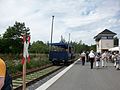
City-Bahn to Stollberg at St. Egidien station (2016)
.JPG)


Galleries
Buildings

Railway viaduct in Neuwürschnitz (2016)
Signal box 2 at the Neuoelsnitz level crossing (2016)

Oelsnitz (Erzgeb) railway station, command signal box (2015)

Viaduct Oelsnitz (Viaduct Hegebachtal; west side facing south) around 1900, in the background the Vereinsglück shafts
Viadukt Oelsnitz (Viadukt Hegebachtal, east side to the north) in 2018 with the vaults now filled with concrete

Railway viaduct in Rödlitz (2016)

St. Egidien, Lungwitzbachtal viaduct (2016)

.JPG)


Pictures from the route

Level crossing at the Hp Mitteloelsnitz (2016)

Tracks in the “Am Auersberg” industrial park in St. Egidien / Lichtenstein / Sa. (2016)


literature
- Erich Preuß , Reiner Preuß : Saxon State Railways . transpress Verlagsgesellschaft, Berlin 1991, ISBN 3-344-70700-0 .
Web links
- Description on www.sachsenschiene.net
- Website of the Regio Infra Service Sachsen GmbH
- Website of the City-Bahn Chemnitz
Individual evidence
- ↑ a b Chemnitz model stage 5: Expansion of the Stollberg - Oelsnitz variant investigation and preliminary planning. (PDF; 7.2 MB) Citizen information event. Central Saxony transport association , August 24, 2015, accessed on October 23, 2016 .
- ↑ a b Chemnitz model current. (PDF; 1.1 MB) Issue No. 4 November 2016. Verkehrsverbund Mittelachsen , November 3, 2016, pp. 2–4 , accessed on March 5, 2017 .
- ↑ Equidistant map sheet Stollberg (1905) on www.deutschefotothek.de
- ↑ a b List of infrastructure companies that are subject to approval according to Section 6 AEG. (OOXML; 51.9 KiB) (No longer available online.) Federal Railway Authority, January 19, 2017, archived from the original on March 5, 2017 ; Retrieved March 5, 2017 .
- ↑ Article in the "Freie Presse" on February 22, 2020, accessed on February 23, 2020
- ↑ Chemnitz model. Stage 5: Expansion of Stollberg - Oelsnitz. Central Saxony Transport Association , accessed on November 22, 2017 .
- ↑ a b Jan Oechsner: The start of the new City-Bahn route has been delayed by a few years. Freie Presse , June 26, 2018, accessed July 4, 2018 .
- ↑ Level 5: Expansion of Stollberg - Oelsnitz. Current status. Central Saxony transport association , accessed on May 7, 2020 .
- ↑ The Chemnitz model is getting even bigger. Central Saxony Transport Association , June 26, 2020, accessed on June 26, 2020 .