
Łazdoje
| Łazdoje | |||
|---|---|---|---|

|
|
||
| Basic data | |||
| State : | Poland | ||
| Voivodeship : | Warmia-Masuria | ||
| Powiat : | Kętrzyn | ||
| Gmina : | Kętrzyn | ||
| Geographic location : | 54 ° 0 ' N , 21 ° 18' E | ||
| Residents : | 340 | ||
| Telephone code : | (+48) 89 | ||
| License plate : | NKE | ||
| Economy and Transport | |||
| Street : | Ext. 591 : ( Russia -) Michałkowo - Barciany - Kętrzyn - Wilkowo ↔ Rydwągi - Mrągowo | ||
| Pilec - Wólka Pilecka → Łazdoje | |||
| Rail route : | no rail connection | ||
| Next international airport : | Danzig | ||


Łazdoje (German Laxdoyen ) is a village in the Polish Warmian-Masurian Voivodeship . The village is part of the Schulzenamt Wilkowo ( Wilkendorf ) in the rural community Kętrzyn ( Rastenburg ) in the powiat Kętrzyński ( Rastenburg district ).
Geographical location
The village is located in historic East Prussia , about twelve kilometers southwest of Kętrzyn ( Rastenburg ) and 58 kilometers northeast of Olsztyn ( Allenstein ). About 40 kilometers to the north is the border with the Russian exclave Kaliningrad Oblast . Neighboring villages are Wilkowo ( Wilkendorf ) in the north, Rydwągi ( Rudwangen ) in the south and Wólka Pilecka ( Stechernsruh ) to the west.
history
The settlement of the village took place in 1374 according to Kulm law . With the establishment of the village, the residents were exempted from tax burdens for 14 years. In 1792 the manor was bought by a married couple Hoverbeck . Around 1830, the aristocratic village consisted of 2038 acres of land, a farm and four farms. After the manor had gone bankrupt under the previous owners, the Tiburzius family, after the peasant and manorial conditions had been regulated , it was auctioned by Christian Stadie in November 1830 .
On April 30, 1874, the district of Laxdoyen No. 4 was formed from the rural communities of Bärenwinkel ( Barwik ), Wilkendorf ( Wilkowo ), Marienhof ( Marzenin ) and Laxdoyen themselves. On September 30, 1928, the rural community of Bärenwinkel and the Laxdoyen manor district were combined to form the rural community of Laxdoyen. In the 1920s, the 500 hectare area with three outbuildings belonged to Major Siegfried Mackentanz . Mackentanz grew grain here and raised remonts .
In 1945 Laxdoyen belonged to the district of Rastenburg in the administrative district of Königsberg in the province of East Prussia of the German Empire .
In the spring of 1945 the district was occupied by the Red Army . In the summer of 1945 Laxdoyen, along with the southern half of East Prussia and all of West Prussia, was placed under Polish administration by the Soviet occupying power, in accordance with the Potsdam Agreement . As a result, the influx of Polish migrants began in the district, partly from the areas east of the Curzon Line . Unless the German villagers had fled, most of them were subsequently driven out of Laxddoyen .
In 1970 a cinema with 50 seats was available to the now 249 inhabitants. Since the reform of the administrative structure in 1973, Łazdoje has been part of the Wilkowo Schulzenamt in the Kętrzyn municipality.
Population development until 1945
| year | Residents | Remarks |
|---|---|---|
| 1816 | 66 | |
| 1831 | 84 | |
| 1852 | 116 | |
| 1858 | 111 | 93 Evangelicals and 18 Catholics |
| 1864 | 134 | on December 3rd |
| 1910 | 151 | on December 1st |
| 1933 | 172 | |
| 1939 | 174 |
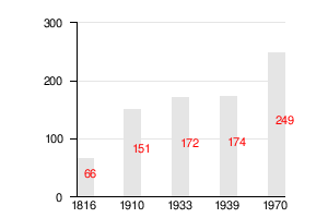
- Bar chart of the population to date
Laxdoyen District (1874–1945)
When it was established in 1874, the Laxdoyen district included:
| German name | Polish name | Remarks |
|---|---|---|
| Bear corner | Barwik | 1928 incorporated into Laxdoyen |
| Lax doyen | Łazdoje | |
| Mariendorf | Marzenin | 1928 incorporated into Wilkendorf |
| Wilkendorf | Vilkovo |
church
Until 1945 Laxdoyen was in the Protestant church Bäslack ( Polish Bezławki ) in the church province of East Prussia of the Church of the Old Prussian Union and in the Catholic Church Heiligelinde (Polish Święta Lipka ), from 1937 to 1945 in the church Wilkendorf (Polish Wilkowo ) in the then diocese of Warmia . On the Catholic side, Łazdoje still belongs to Wilkowo, whose parish is incorporated into the current Archdiocese of Warmia . On the evangelical side, the residents of Łazdojes orient themselves towards the parish of Kętrzyn in the Masurian diocese of the Evangelical-Augsburg Church in Poland .
Attractions
The manor house from the beginning of the 20th century has been preserved, but lost its exterior decor during renovation work after the Second World War.
traffic
The provincial road 591 runs through the village, which leads to the north through Kętrzyn after about ten kilometers and ends after about 40 kilometers at the border with the Russian Kaliningrad Oblast . There is no border crossing here. In a southerly direction, the DW 591 leads after about 15 kilometers to Mrągowo, where it ends with the confluence with the national road 59 . There are bus connections to Kętrzyn and Mrągowo.
Łazdoje does not have its own train stop. The nearest train station is in Kętrzyn, from where the PKP offers direct connections to Olsztyn and Poznan .
The nearest international airport is Gdansk Lech Wałęsa Airport, about 190 kilometers to the west .
literature
- Leopold Krug : The Prussian Monarchy - represented topographically, statistically and economically . Part 1: Province of East Prussia , Berlin 1833, p. 452, item 43.
- Tadeusz Swat: Dzieje Wsi . In: Aniela Bałanda and others: Kętrzyn. Z dziejów miasta i okolic . Pojezierze, Olsztyn 1978, p. 204 ( Seria monografii miast Warmii i Mazur ).
Web links
- Laxdoyen district (Rolf Jehke, 2005)
- GenWiki: Laxdoyen
- Ostpreussen.net: Laxdoyen - East Prussia
Individual evidence
- ↑ a b Swat 1978, p. 204
- ^ A b Leopold Krug : The Prussian Monarchy - represented topographically, statistically and economically . Part 1: Province of East Prussia , Berlin 1833, p. 452, item 43.
- ↑ Evidence of the property corrections made by the adl in the department of the Higher Regional Court in Königsberg from July 1st to December 1st, 1830. Concerning goods . In: Preußische Provinzial-Blätter , Volume 5, Königsberg 1831, pp. 151–155, especially p. 154.
- ↑ territorial.de, District Laxdoyen , May 7, 2005
- ↑ a b ostpreussen.net, Lazdoje - Laxdoyen , May 1, 2003
- ↑ Alexander August Mützell and Leopold Krug : New topographical-statistical-geographical dictionary of the Prussian state . Volume 3: Kr – O , Halle 1822, p. 78, item 993.
- ^ Kraatz: Topographical-statistical manual of the Prussian state . Berlin 1856, p. 340.
- ↑ Adolf Schlott: Topographical-statistical overview of the government district of Königsberg, based on official sources . Hartung, Königsberg 1861, p. 208, item 8. 137.
- ↑ Prussian Ministry of Finance: The results of the property and building tax assessment in the Königsberg administrative district : Berlin 1966, Rastenburg district, p. 10, item 81.
- ^ Municipal directory Germany 1900 - Rastenburg district , accessed on June 28, 2008.
- ^ A b Michael Rademacher: German administrative history from the unification of the empire in 1871 to the reunification in 1990. rastenburg.html # ew33rastlaxdoy. (Online material for the dissertation, Osnabrück 2006).
- ↑ Rolf Jehke, District Laxdoyen
- ↑ Walther Hubatsch , History of the Protestant Church in East Prussia , Volume 3 Documents , Göttingen 1968, p. 472
- ↑ Laxdoyen at GenWiki

Official seat: City of Kętrzyn
Villages:
Biedaszki (Groß Neuhof) |
Czerniki (Black Stone) |
Filipówka (Philippsdorf) |
Gałwuny (large Galbuhnen) |
Gnatowo (Wilhelmshöhe) |
Jeżewo (Jeesau) |
Koczarki (Kotzargen / Eichhöhe) |
Kruszewiec (Krausendorf) |
Langanki (Langanken) |
Linkowo (Schrengen) |
Mażany (Masehnen) |
Muławki (Muhlack) |
Nakomiady (calibration media) |
Nowa Różanka (New Rosenthal) |
Nowa Wieś Kętrzyńska (Neuendorf) |
Pożarki (Pohiebels) |
Pręgowo (Prangenau) |
Salpik (salt germ) |
Sławkowo (Reimsdorf) |
Stara Różanka (Alt Rosenthal) |
Wajsznory (white cords) |
Wilkowo (Wilkendorf) |
Wopławki (Woplaucken)
Other localities: Bałowo (Ballau) | Bałtrucie (Rastenburgswalde) | Banaszki ( Banaszki ) | Biedaszki Małe (Klein Neuhof) | Brzeżnica (Birkenwerder) | Cegielnia (Louisenthal) | Dąbrowa (Damerau) | Działki (Rastenburgsfelde) | Gierłoż (Görlitz) | Głobie (Glubenstein) | Gnatowo-Kolonia | Godzikowo (Gisbertshof) | Góry (Uri) | Grabno (Weitzdorf) | Gromki (Heinrichshöfen) | Gryzławki (semolina) | Henrykowo (Heinrichssorge) | Jankowo (Jankendorf) | Jurki (Georgenberg) | Karolewo (Carlshof) | Kaskajmy (Groß Köskeim) | Katkajmy (Kattkeim) | Kętrzyńska Kępa | Kotkowo (Kotittlack) | Kwiedzina (Queden) | Łazdoje (Laxdoyen) | Marszewo (Moritzhof) | Martiany (Mertenheim) | Muławski-Dwór (Muhlackshof) | Nowa Wieś Mała (Klein Neuendorf) | Nowy Mikielnik (New Mickelnick) | Nowy Młyn (Neumühl) | Olchowo (Erlenhof) | Osewo (Wossau) | Ostry Róg (Scharfenort) | Owczarki (sheep farm) | Owczarnia (Peace Height ) | Parcz (Partsch) | Poganowko (Klein Bürgersdorf) | Poganowo ( Groß Bürgersdorf , 1928–1945: Bürgersdorf ) | Porębek (Prömbock) | Przeczniak (Hermannshof) | Rybniki (forest lake) | Salpik Dolny (Nieder Salpkeim) | Smokowo (dragon stone) | Stachowizna (deer stable) | Stadniki (Heinrichssorge) | Strzyże (Streitz) | Suchodoły (Peace Valley) | Sykstyny (Sistine) | Trzy Lipy (resting height) | Ugiertowo (Augarshof) | Wilamowo (Wilhelmsdorf) | Windykajmy (Windtkeim) | Wólka ( Wolka , 1938–1945: Spittel ) | Wymiarki (Charlottenberg) | Zalesie Kętrzyńskie (Hinzenhof)
Other locations: Borki (Borken)