Barciany
| Barciany | ||
|---|---|---|

|
|
|
| Basic data | ||
| State : | Poland | |
| Voivodeship : | Warmia-Masuria | |
| Powiat : | Kętrzyn | |
| Geographic location : | 54 ° 13 ' N , 21 ° 21' E | |
| Height : | 68 m npm | |
| Residents : | 1154 (2011) | |
| Postal code : | 11-410 | |
| Telephone code : | (+48) 89 | |
| License plate : | NKE | |
| Economy and Transport | ||
| Street : | Ext. 590 : Biskupiec - Reszel - Korsze → Barciany | |
| Ext. 591 : Mrągowo - Kętrzyn ↔ Michałkowo | ||
| Rail route : | no rail connection | |
| Next international airport : | Danzig | |
| Gmina | ||
| Gminatype: | Rural community | |
| Gmina structure: | 71 localities | |
| 23 school authorities | ||
| Surface: | 294.00 km² | |
| Residents: | 6147 (June 30, 2019) |
|
| Population density : | 21 inhabitants / km² | |
| Community number ( GUS ): | 2808022 | |
| Administration (as of 2015) | ||
| Community leader : | Ryszard Kozyra | |
| Address: | ul.Wojska Polskiego 7 11-410 Barciany |
|
| Website : | www.barciany.pl | |
Barciany [ barˈtɕanɨ ] ( German Barten , Lithuanian Barčianiai ) is a place and seat of the rural community Barciany in the powiat Kętrzyński ( Rastenburg district ) of the Polish Warmian-Masurian Voivodeship .
Geographical location
The village is located on the river Liebe ( Polish Liwna ) in the historical region of East Prussia , about 75 kilometers northeast of Olsztyn ( German Allenstein ) and 16 kilometers north of the district town of Kętrzyn (Rastenburg) .
Place Barciany (City of Barten)

history
Place name
The place name was mentioned in 1353 as "zu Barten" and was only given the names Barciany, Barty, Borty, Barthen and Barten in 1880. The name is reminiscent of the Prussian tribe of the Barten who lived in this landscape in the Middle Ages. It is derived from the Prussian “bar, beard”: flow, flow quickly .
Local history
In the 14th century the settlement got its own church, and the Ordensburg Barten of the Teutonic Order was built. Both are still preserved today. The order keeper von Barten was subordinate to the order commander of Brandenburg . In the 19th century, the palace was the seat of the domain office.
In 1630 the place received city rights , but could hardly develop apart from the important traffic flows. With 1488 inhabitants in 1885 and 1541 inhabitants in 1939, Barten remained a small agricultural town, although it had been connected to the district town of Rastenburg , the neighboring district town of Gerdauen and Nordenburg by small railways since the beginning of the 20th century . At the beginning of the 20th century, Barten had a Protestant church and a district court.
Until 1945 Barten belonged to the district of Rastenburg in the administrative district of Königsberg in the province of East Prussia of the German Empire .
Towards the end of the Second World War , the Red Army occupied the region in the spring of 1945 . In summer 1945 Barten was placed under Polish administration by the Soviet occupying power . The Poles introduced the place name Barciany for Barten .
The place lost its city rights, but is now the center of a larger municipality, the Gmina Barciany in the powiat Kętrzyński (Rastenburg district) . This is slightly larger than the former Rastenburg district and which also includes the town of Reszel (Rößel) .
Population numbers
| year | Residents | Remarks |
|---|---|---|
| 1782 | over 1200 | |
| 1802 | 1335 | |
| 1810 | 1332 | |
| 1816 | 1242 | including 1238 Evangelicals, three Catholics and one Jew |
| 1821 | 1505 | |
| 1831 | 1537 | |
| 1858 | 1543 | of which 1511 Protestants and 32 Catholics (no Jews) |
| 1864 | 1690 | on December 3rd |
| 1871 | 1734 | |
| 1885 | 1488 | |
| 1900 | 1401 | almost only evangelicals |
| 1910 | 1221 | on December 1st |
| 1933 | 1473 | |
| 1939 | 1651 | |
| 2011 | 1154 |
District Barten, Domain (1874–1929)
On April 30, 1874, the district of Barten, domain was established. It existed until 1929 and belonged to the county Rastenburg in the administrative district of Kaliningrad in the Prussian province of East Prussia . The following belonged to the district:
| German name | Polish name | Remarks |
|---|---|---|
| Barten, domain | (Barciany) | 1928 incorporated into the municipality of Barten |
| Barten, freedom of office | In 1880 incorporated into the town of Barten | |
| Freudenberg | Radosze | |
| Taborwiese | Taborzec |
After the change of the manor district of Barten domain to the municipality of Barten, the administrative district was renamed on June 22nd, 1929 in the "administrative district Taborwiese". Until 1945 only the towns of Freudenberg and Taborwiese belonged to it.
Ordensburg
Churches
Church building
Roman Catholic Parish Church
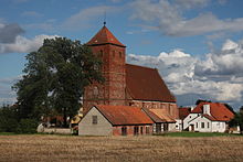
The church in Barciany is a hall from 1389. The sacristy attached to the south was provided with a barrel vault in 1400. The east gable was rebuilt in 1714, and the additional southern vestibule (next to the one in the north) with a new ribbed cross vault was built in 1783. The tower from the 16th century was built from 1729 to 1741 by master mason Hünchen and carpenter Effried from Königsberg (Russian: Kaliningrad) rebuilt and received the current roof in 1804.
The interior of the church was originally closed off by a vault, now with a wooden ceiling. An extensive interior renovation took place in 1989/90. Distinctive pieces of equipment are the altar with the coat of arms of the von Rautter family from 1643, the organ - a work from 1750 by Adam Gottlob Casparini from Königsberg, and two - no longer existing - chandeliers , both of which were probably a gift from Tsarina Elisabeth were.
From the Reformation to 1945 the church was a Protestant house of worship. It was expropriated in favor of the Roman Catholic Church and received a new consecration in 1962 with the name Niepokalanego Serca Maryi (" Immaculate Heart of Mary ").
Greek Catholic Parish Church
Today there is in Barciany, in addition to the Roman Catholic parish church, a Greek Catholic parish church that maintains the Byzantine-Ukrainian rite.
Evangelical Lutheran Chapel
The Evangelical Lutheran Church has a small chapel in Barciany at Mazurska Street. It was inaugurated on October 26, 1991 by Bishop Jan Szarek . The parish belongs to the parish church of St. Johannes in Kętrzyn (Rastenburg) in the Masuria diocese of the Evangelical-Augsburg Church in Poland .
Parishes
Before 1945, a predominantly Protestant population lived in Barten . The parish was incorporated into the church district Rastenburg (Polish: Kętrzyn) within the church province of East Prussia of the Evangelical Church of the Old Prussian Union .
Almost without exception, Catholic Christians have lived in Barciany since 1945, the majority of whom belong to the Roman Catholic Church in Poland . Her parish Barciany belongs to the deanery Kętrzyn II - Północny-wschód ( Rastenburg II, northeast) in the Archdiocese of Warmia .
In addition, there is a parish of the Greek Catholic Church in Poland in Barciany , which is incorporated into the Archeparchy Przemyśl-Warsaw .
After the flight and expulsion of the German population, the formerly predominant Protestant church now has a small parish in Barciany again, which is affiliated to the mother parish in Kętrzyn (Rastenburg) within the diocese of Masuria of the Evangelical-Augsburg Church in Poland .
traffic
At the place is the intersection of the two provincial roads DW 590 ( Biskupiec (Bischofsburg) - Reszel (Rößel) - Korsze (Korschen) - Barciany) and DW 591 ( Michałkowo (Langmichels) - Kętrzyn (Rastenburg) - Mrągowo (Sensburg) ). Coming from the region, the side roads from Mołtajny (Molthainen) via Bobrowo (Bieberstein) and from Taborzec (Taberwiese) end in Barciany.
A railway connection has not existed since the earlier railway lines Barten – Rastenburg (today Polish: Kętrzyn), Barten – Gerdauen (today Russian: Schelesnodoroschny) and Barten – Nordenburg (Russian: Krylowo), which were operated by the Rastenburger Kleinbahnen , except after 1945 Were put into operation.
Personalities
Native of the place
- Leo Cholevius (born March 11, 1814 in Barten), philologist and literary historian († 1878)
- Gustav Dömpke (* 1853 in Barten), music critic in Königsberg and Vienna († 1923)
- Karl-Heinz Kurras (born December 1, 1927 in Barten), German police officer, shooter and Stasi employee († 2014)
- Lubomir Gliniecki (born March 20, 1957 in Barciany), Polish politician, economist and deputy member of the Sejm
Gmina Barciany
General
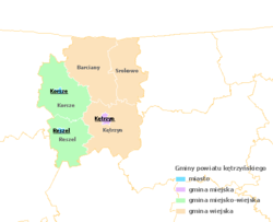
The rural community of Barciany is located in the northern center of the powiat Kętrzyński . It borders to the north on the Gorodskoje posselenije Schelesnodoroschnoje (township Schelesnodoroschny (Gerdauen) ) in the Russian Kaliningrad Oblast (region Königsberg (Prussia) ), on the northwest by the Gmina Sępopol (Schippenbeil) , on the southwest by the Gmina Korsze (Korschen) , in South to the Gmina Kętrzyn (Rastenburg) and to the east to the Gmina Srokowo (Drengfurth) .
82% of the municipal area of 293.62 km² is used for agriculture and 8% for forestry. In terms of area, the Gmina Barciany makes up 24.21% of the area of the Powiat Kętrzyński .
Community structure
The following localities belong to the rural municipality of Barciany:
| Polish name | German name (until 1945) | Polish name | German name (until 1945) |
|---|---|---|---|
| Aptynty | Ink inks | Modgarby | Mod sheaves |
| Arklity | Arklitten | Mołtajny | Molthainen , 1938–45: Molteinen |
| Asuny | Assaunen | Momajny | Moments |
| Barciany | Beards | Moruny | Maraunen |
| Błędowo | Blandau | Niedziałki | Five-stroke |
| Bobrowo | Bieberstein | Niedziały | Elisenthal |
| Cacki | Schatzelshöfchen | Ogródki | Baumgarten |
| Czaczek | Darling | Pastwiska | Dairy stall |
| Dębiany | Dom stretching | Pieszewo | Petermanns |
| Dobrzykowo | Dawerwalde | Piskorze | Ludwigshöhe |
| Drogosze | Dönhofstädt | Podławki | Podlacken |
| Duje | Doyen , 1938–45: Dugen | Radoski Dwór | Freudenbergswalde |
| Frączkowo | Fritzendorf | Radosze | Freudenberg |
| Garbnik | Garbnick | Toboggan | Rodehlen |
| Garbno | Laggarben | Rowy | Rawlack |
| Gęsie Góry | Sansgarben | Ruta | Rauttershof |
| Gęsiki | Meistersfelde | Rutka | Rauttersfelde |
| Gęsiniec Wielki | Rzymek | Romberg | |
| Glinka | Friedrichswiese | Silginy | Sillginnen |
| Główczyno | Egloffstein | Skandawa | Skandau |
| Górki | mountain | Skis | Wehlack |
| Gradowo | Old hail | Skoczewo | Hermannshof |
| Gumniska | Silzkeim | Sławosze | Henriettenfeld |
| Kąpławki | Kamplack | Solkieniki | Sol kink |
| Kiemławki Małe | Klein Kemlack | Staniszewo | Albertinhausen |
| Kiemławki Wielkie | Great Kemlack | Stary Dwór Barciański | Althof Barten |
| Kolwiny | Piston beans | Suchawa | Sausgörken |
| Kotki | Frills | Święty Kamień | Heiligenstein |
| Krelikiejmy | Kröligkeim | Szaty Wielkie | Big shade |
| Krymławki | Krimlack | Taborzec | Taberwiese |
| Krzeczewo | Sonnenburg | Wielewo | Welcome comb |
| Kudwiny | Kudwins | Wilkowo Małe | Klein Wolfsdorf |
| Maciejki | Blumenthal | Wilkowo Wielkie | Groß Wolfsdorf |
| Markuzy | Markhausen | Winda | Turn |
| Markławka | Marrow lacquer | Zalewska Góra | |
| Michałkowo | Langmichels |
literature
- Daniel Heinrich Arnoldt : Brief messages from all preachers who have admitted to the Lutheran churches in East Prussia since the Reformation . Königsberg 1777, pp. 284–287.
- Johann Friedrich Goldbeck : Complete topography of the Kingdom of Prussia . Part I: Topography of East Prussia . Königsberg / Leipzig 1785, p. 18, no. 3).
- August Eduard Preuss : Prussian country and folklore or description of Prussia. A manual for primary school teachers in the province of Prussia, as well as for all friends of the fatherland . Bornträger Brothers, Königsberg 1835, pp. 514–515, no. 114.
- Lotar Weber: About the boundaries of beards . In: New Prussian Provincial Papers . Fourth episode, volume 13, Königsberg i. Pr. 1876, pp. 222-226.
Web links
- Municipality website (Polish)
- 146 historical recordings of the city of Barten with the order castle and churches
Individual evidence
- ↑ population. Size and Structure by Territorial Division. As of June 30, 2019. Główny Urząd Statystyczny (GUS) (PDF files; 0.99 MiB), accessed December 24, 2019 .
- ^ Website of the municipality, Władze , accessed on February 18, 2015
- ^ History of Barciany - Barten
- ↑ Johannes Voigt : History of Prussia from the oldest times to the fall of the rule of the Teutonic Order . Volume 6: The time of Grand Master Konrad von Jungingen, from 1393 to 1407. Constitution of the order and the country . Königsberg 1834, p. 547.
- ^ A b August Eduard Preuss : Prussian country and folklore or description of Prussia. A manual for primary school teachers in the province of Prussia, as well as for all friends of the fatherland . Bornträger Brothers, Königsberg 1835, pp. 514–515, no. 114.
- ^ A b c d Michael Rademacher: German administrative history from the unification of the empire in 1871 to the reunification in 1990. Rastenburg district. (Online material for the dissertation, Osnabrück 2006).
- ↑ a b Meyer's Large Conversation Lexicon . 6th edition, Volume 2, Leipzig / Vienna 1905, p. 401.
- ^ Johann Friedrich Goldbeck : Complete topography of the Kingdom of Prussia . Part I: Topography of East Prussia . Königsberg / Leipzig 1785, p. 18, no. 3).
- ↑ a b c d Alexander August Mützell, Leopold Krug : New topographical-statistical-geographical dictionary of the Prussian state . Volume 5: T-Z. Halle 1823, pp. 250–251, item 33.
- ↑ Adolf Schlott: Topographical-statistical overview of the government district of Königsberg, based on official sources . Hartung, Königsberg 1861, p. 204, point 11.
- ^ Prussian Ministry of Finance: The results of the property and building tax assessment in the administrative district of Königsberg. Berlin 1966, Rastenburg district, p. 2, item 7.
- ^ Gustav Neumann: Geography of the Prussian State . 2nd edition, Volume 2, Berlin 1874, pp. 15-16, item 8.
- ^ Municipal directory Germany 1900 - Rastenburg district.
- ^ Wieś Barciany w liczbach
- ^ Rolf Jehke, District Barten Domain
- ^ Church in Barten at ostpreussen.net
- ↑ Parishes / Ev.-luth. Barciany Chapel


