Bolu
| Bolu | ||||
|
||||
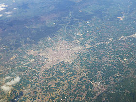
 Aerial view of Bolu |
||||
| Basic data | ||||
|---|---|---|---|---|
| Province (il) : | Bolu | |||
| Coordinates : | 40 ° 44 ' N , 31 ° 36' E | |||
| Height : | 725 m | |||
| Residents : | 171,180 (2018) | |||
| Telephone code : | (+90) 374 | |||
| Postal code : | 14,000 | |||
| License plate : | 14th | |||
| Structure and administration (as of 2019) | ||||
| Structure : | 43 Mahalle | |||
| Mayor : | Tanju Özcan ( CHP ) | |||
| Website: | ||||
| Bolu County | ||||
| Residents : | 205,525 (2018) | |||
| Surface: | 1,616 km² | |||
| Population density : | 127 inhabitants per km² | |||
Bolu ( ancient Greek Βιθύνιον Bithynion , during Roman times Claudiopolis , or Hadriana ) is a city in Turkey and the capital of the province of Bolu of the same name . It also forms the central district ( Merkez ).
geography
The city is located in northern Turkey at 725 m above sea level and can be reached via the motorway from Istanbul to Ankara ( O4 ). On January 27, 2007, the Bolu Tunnel replaced the section of the motorway that had previously wound over the Bolu Mountains. The area around Bolu is very wooded and known for its lake landscape.
The district borders in the north on the province of Düzce (districts Kaynaşlı , the provincial capital Düzce itself and Yığılca ). The remaining borders form (internally) the circles - starting clockwise in the north - Mengen , Yeniçağa , Dörtdivan , Kıbrıscık , Seben and Mudurnu .
In addition to the district town, the district consists of another municipality ( Belde ): Karacasu with 2,150 inhabitants. There are also 112 villages ( Köy ) with an average population of 287 inhabitants. Only two have more than a thousand inhabitants: Gölköy (2,805) and Doğancı (1,137 inhabitants).
Population development
The following table shows the comparative population level at the end of the year for the province, the central district and the city of Bolu as well as the respective share at the higher administrative level. The figures are based on the address-based population register (ADNKS) introduced in 2007.
| year | province | district | city | ||
|---|---|---|---|---|---|
| real | % | real | % | real | |
| 2018 | 311.810 | 65.91 | 205,525 | 83.29 | 171.180 |
| 2017 | 303.184 | 65.87 | 199,702 | 84.22 | 168.187 |
| 2016 | 299,896 | 65.09 | 195.209 | 83.51 | 163.018 |
| 2015 | 291,095 | 63.99 | 186.275 | 82.56 | 153,783 |
| 2014 | 284,789 | 62.45 | 177,855 | 81.45 | 144.864 |
| 2013 | 283,496 | 61.62 | 174,687 | 80.22 | 140.131 |
| 2012 | 281.080 | 61.32 | 172.355 | 76.16 | 131.264 |
| 2011 | 276.506 | 60.52 | 167,343 | 75.20 | 125,842 |
| 2010 | 271.208 | 59.18 | 160,500 | 74.70 | 119,898 |
| 2009 | 271,545 | 58.58 | 159.070 | 75.45 | 120.021 |
| 2008 | 268,882 | 58.06 | 156,100 | 76.87 | 120.001 |
| 2007 | 270.417 | 57.87 | 156,498 | 68.92 | 107,857 |
history
The city was founded by King Prusias I (230–182 BC) of Bithynia , but excavations showed that the place was as early as the 7th century BC. Was settled. The city is handed down in the 10th century by Constantine VII in his De thematibus , in which he describes the place as the center of the Mariandyn people. The Mariandynia region is first mentioned in the fragments of Eupolis in the 5th century BC. Mentioned.
During the Roman era, the city was sometimes named after the Roman emperors Claudius Claudiopolis and Hadrian Hadriana . Under the Byzantine emperor Theodosius II (408-450) it became the capital of the new province of Honorias . Also during the Byzantine period it was the seat of a metropolitan (today titular bishopric ).
In 1325 the city fell to the Ottomans. Under Sultan Bayezid I (1389–1402) it received new urban accents.
The city is known for the national hero Köroğlu , who lived in the 16th century and rose against the Bolu Bey, among others. In addition to his sword, he could also handle lyric poetry and his saz . He wrote the following lines: "The shooting rifle was invented, bravery has suffered as a result, my scimitar will now rust."
Climate table
| Bolu (743 m) | ||||||||||||||||||||||||||||||||||||||||||||||||
|---|---|---|---|---|---|---|---|---|---|---|---|---|---|---|---|---|---|---|---|---|---|---|---|---|---|---|---|---|---|---|---|---|---|---|---|---|---|---|---|---|---|---|---|---|---|---|---|---|
| Climate diagram | ||||||||||||||||||||||||||||||||||||||||||||||||
| ||||||||||||||||||||||||||||||||||||||||||||||||
|
Average Monthly Temperatures and Rainfall for Bolu (743 m)
|
||||||||||||||||||||||||||||||||||||||||||||||||||||||||||||||||||||||||||||||||||||||||||||||||||||||||||||||||||||||||||||||||||||||||||||||||||||||
Attractions
- Talk (Flaviopolis, Kratya, talk, Ind Geredele)
- Seben Çeltikler
- Abant lake , place of excursions
- Yedigöler (Seven Lakes)
- Göyük Akşemseddin mausoleum
- Kartalkaya winter sports center
Personalities
- Antinous , lover of Hadrian
- Haydar Zafer , wrestler
- Feridun Zaimoğlu , writer and visual artist
Web links
Individual evidence
- ↑ a b Türkiye Nüfusu İl ilçe Mahalle Köy Nüfusları , accessed on May 18, 2019
- ↑ Central Dissemination System / Merkezi Dağıtım Sistemi (MEDAS) of the TÜIK , accessed on May 18, 2019
- ^ The origins of the pontic house. AB Bosworth, PV Wheatley, Journal of Hellenic Studies 118: 158 1998.


