Bornum (Hanover)
|
Bornum
City of Hanover
Coordinates: 52 ° 20 ′ 58 ″ N , 9 ° 41 ′ 22 ″ E
|
|
|---|---|
| Height : | 62-78 m |
| Area : | 99 ha |
| Residents : | 1422 (December 31, 2017) |
| Population density : | 1,436 inhabitants / km² |
| Incorporation : | January 1, 1920 |
| Postal code : | 30453 |
| Area code : | 0511 |
|
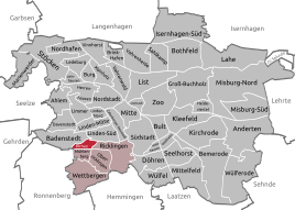
Location of Bornum in Hanover
|
|
Bornum is a district of Hanover and is part of the Ricklingen district .
Location and general
Bornum is located in the southwest of the city. It borders on the following other districts: in the west and north on Badenstedt , in the north-east on Linden-Süd , in the east on Ricklingen , in the south-east only via a crossing point on Oberricklingen , in the south on the Mühlenberg . In the southwest, Bornum forms the outer border of Hanover over a length of around 200 m to the Ronnenberg district of Empelde . Nevertheless, Bornum has a relatively central location; the distance to the city center is around four kilometers. The road in and out of the south-west of Hanover, Bornumer Strasse , which, curiously enough, bears this name on both sides of Bornum and on its own territory, runs through Bornum . In terms of area, it is the fourth smallest district, in terms of population it is the second smallest after Wülferode (the two "half-town districts" Brink-Hafen and Nordhafen are excluded).
history
The linguistically typical Low German place name consists of “Born” (= well, source) and “Heim”. The earliest known documentary mention dates from 1130. Almost the entire Middle Ages included the place 13-14 farms. A bell from 1452 hung in the half-timbered chapel, which no longer exists. Bornum was a clustered village on the road from Empelde to Linden. The Mindener Chaussee , which was expanded in 1782, crossed the town in an east-west direction. Bornum is bounded to the west and north by the Hanover – Altenbeken railway line, completed in 1872, and the Hanover freight bypass . The area further to the north also belonged to Bornum, as can be seen today in the forest area "Bornumer Holz" and an allotment garden colony of the same name, which now belong to Badenstedt. When the Körtingsdorf settlement was built, it was even in Bornum. In 1909 Bornum was incorporated into the then town of Linden . In view of this north-facing orientation, today's amalgamation with more southerly districts in the Ricklingen district appears ahistorical. In 1920 Bornum came to Hanover as part of Linden. Street names were not introduced until 1953; before there were only house numbers. The only noteworthy building steeped in history is the “Lindenhof” , a traditional restoration, accommodation and meeting place.
residential area
Bornum consists of two fundamentally different halves. The residential area is located some distance west of Bornumer Straße . This is framed by railway lines to the north and west, south of the federal highway 65 ("Bückeburger Allee"). For normal car traffic there is only one dead end connection via the street Im Dorfe to Bornumer Straße , while buses - the line 581 running between Mühlenberg and Stöcken - also have a tunnel through a tunnel on the northern edge. Due to this isolated location without any transition to the development, there is hardly any exchange with the neighboring districts. However, the own population is too small for the operation of shops, associations and public institutions. Much like school, post office, savings bank, church, Easter bonfire, district festivals there were at different times, but nothing could last. Due to the location, Bornum disproportionately has one of the only eleven Hanover S-Bahn stops in the residential area , which is accordingly less frequented here. For school, sports, church and other activities, the Bornum residents go to other parts of the city, mostly Badenstedt or Mühlenberg.
industrial Estate

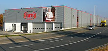
Business is located along Bornumer Straße and east of it up to the apex of Tönniesberg . This, in turn, includes institutions that are important for the south-west of Hanover, the entire city or even beyond: the Hanover wholesale market , fire station 4 of the professional fire brigade with some special tasks and the volunteer fire brigades Bornum and Ricklingen, a factory of the Harry-Brot company , a trucking office , Branches of the retail chains Metro and Kaufland , a well-known fast food restaurant and a regular "antique market". Since 2005 the Lower Saxony State Theater Hanover , which among other things plays the opera, has set up its rehearsal, workshop and storage center. The previously conspicuous cluster of hardware stores, however, disappeared as a result of new settlements in neighboring Linden-Süd.
literature
- Uwe Ohainski , Jürgen Udolph : The place names of the district and the city of Hanover (= Lower Saxony Place Name Book , Part 1) (= publications by the Institute for Historical Research at the University of Göttingen , Vol. 37), Bielefeld: Verlag für Regionalgeschichte, 1998, ISBN 978- 3-89534-230-1 and ISBN 3-89534-230-0 , pp. 61f.
- Ilse Rüttgerodt-Riechmann: Bornum. In: Monument topography of the Federal Republic of Germany , architectural monuments in Lower Saxony, City of Hanover , part 2, vol. 10.2, ed. by Hans-Herbert Möller , Lower Saxony State Administration Office - Institute for Monument Preservation , Friedr. Vieweg & Sohn Verlagsgesellschaft mbH, Braunschweig 1985, ISBN 3-528-06208-8 , p. 162; as well as Bornum in the addendum : List of architectural monuments acc. Section 4 ( NDSchG ) (excluding architectural monuments of the archaeological monument preservation), status: July 1, 1985, City of Hanover , Lower Saxony State Administration Office - publications by the Institute for Monument Preservation, p. 25
- Horst Kruse : Bornum farm owner and family customer. Bornum in Calenberg, later part of Linden, today part of Hanover , Hanover, Körtingsdorf 7: H. Kruse, 1965 [published in 1966]
- Helmut Zimmermann : Bornum - one of the most unknown districts of Hanover , in which: Linden. From the farming village to the Ihmezentrum (= forays into Hanover's history ), Harenberg-Labs, Hanover 1986, ISBN 3-89042-019-2 , pp. 78–84
- Hartmut Herbst, Erhardt Krübbe: Bornum. From the farming village to the district. History of a Hanover district in texts and images ( district culture work. District culture work - for example ... ), ed. from the city of Hanover, dr Oberstadtdirektor, Kulturamt, Hanover: 1992
- Klaus Mlynek : Bornum. In: Klaus Mlynek, Waldemar R. Röhrbein (eds.) U. a .: City Lexicon Hanover . From the beginning to the present. Schlütersche, Hannover 2009, ISBN 978-3-89993-662-9 , pp. 75f.
Individual evidence
- ↑ Structural data of the city districts and boroughs 2017 (PDF). In: Website of the city of Hanover. Retrieved July 25, 2018 .
- ^ District 9: Ricklingen. In: Website of the city of Hanover. Retrieved February 9, 2018 .
- ↑ Bornum . In: Carl Wolff (ed.): The art monuments of the province of Hanover . Issue 1: Districts of Hanover and Linden . Self-published by the provincial administration, Theodor Schulzes Buchhandlung, Hanover 1899, p. 65 .
- ↑ Kurhannoversche Landesaufnahme

