
Mitte (district in Hanover)
| map | |
|---|---|

|
|
| Basic data | |
| Borough | Middle (1) |
| surface | 10.73 km² |
| Residents | 36,354 |
| Population density | 3,269 inhabitants / km² |
| Postcodes | 30159, 30161, 30167, 30169, 30175 |
| Districts |
|
| Web presence | www.hannover.de |
| politics | |
| District Mayor | Cornelia Kupsch (CDU) |
| City District Council (19 seats) |
CDU : 5, SPD : 5, Greens : 4, FDP : 2, Die Linke : 1, Piraten: 1, Non-party: 1 |
Mitte is the 1st district in Hanover . It has 36,354 inhabitants and consists of the districts of Mitte (10,432 Ew.), Calenberger Neustadt (6,744 Ew.), Oststadt (14,108 Ew.) And Zoo (5,070 Ew.) (As of 2016).
center
The Mitte district is located within the Cityring (Brühlstraße - Leibnizufer - Friedrichswall - Aegidientorplatz - Marienstraße - Hamburger Allee - Berliner Allee - Arndtstraße - Schloßwenderstraße - Königsworther Platz ), extended to the south by the Maschpark with the New Town Hall located there .
Old town

The historic old town of Hanover was located in the area between Leine , Friedrichswall, Georgstrasse and Goethestrasse. The historic old town buildings were almost completely destroyed by the bombings in World War II. Only in the area Kramerstraße (z. B. Broyhanhaus ) and Castle Road (u. A. The oldest half-timbered house in the city ) were some half-timbered houses received or were to here translocated . The Aegidienkirche , which was destroyed in the war, was not rebuilt, its ruins now serve as a memorial for the victims of war and violence.

Significant historical buildings in the old town include the market church , the old town hall , the Seilwinderhaus and the Ballhof . The Lower Saxony state parliament now resides in the Leineschloss on Hannah-Arendt-Platz . Remains of the historic city wall and the Begin Tower were integrated into the Historical Museum on the Hohen Ufer , designed by the architect Dieter Oesterlen in 1966 .
The Kreuzkirchenviertel around the Kreuzkirche was completely redesigned after the war and built in the style of the 1950s.
The old town is characterized by diverse gastronomic offers. The old town flea market has been held on Saturdays on the Hohe Ufer for over 40 years . The market hall as “the belly of Hanover” offers a wide range of food and gastronomy on 4000 m² at 73 stands.
Other districts

In the middle of the 19th century Laves laid out the Ernst-August-Stadt between Georgstraße and the railway . As a result of the subway construction, large areas of the city center in the Kröpcke , Georgstrasse and Bahnhofstrasse areas became pedestrian zones . The Kröpcke underground station is the most important station on the Hanover city railway .
The opera house , the theater and other cultural venues are in the immediate vicinity .
Bahnhofstrasse ends in Ernst-August-Platz , the forecourt of the main train station . In October 2008, the Ernst-August-Galerie , a three-story ECE shopping center with specialty shops, service providers and restaurants , opened north-west of the main train station . A smaller shopping center is the Ernst-August-Carrée , which was built from the 2000s in a historic building complex that had long served the Deutsche Bundesbahn as an administrative building.
The Steintor garden community , which existed northwest of the city of Hanover at the beginning of the 19th century , was divided into the localities of Königsworth , Schloßwende, Nordfeld, Fernrode, Vorort, Ostwende, Bütersworth and Westwende in 1829 . In 1843 it was combined with the six localities of the Aegidientor garden community ( Kirchwende , Bult , Kleefeld , Heidorn, Tiefenriede and Emmerberg) to form the suburb of Hanover and incorporated into Hanover in 1859.
The largest anti-nuclear demonstration to date and the largest demonstration in Lower Saxony to date took place at the Klagesmarkt on March 31, 1979 with around 100,000 participants. It was the final rally of the Gorleben trek with around 500 tractors that had started a week earlier in Wendland .
The area between Hamburger Allee and Berliner Allee and the railway, which formerly belonged to Oststadt , was assigned to the Mitte district after the Second World War as part of the new construction of the Cityring. In the 19th century the suburbs Fernrode (the area northwest of the Alte Celler Heerstraße, today's Lister Meile ) and Bütersworth (the area southeast of it) were created here in the course of the city expansion . At or near the Raschplatz are the Hanover regional and district courts , a Cinemaxxkino , the cinema on Raschplatz , discos and bars. The central bus station was rebuilt in 2013/14 next to its previous location. The Hauptbahnhof underground station is one of the most important stations on the Stadtbahn.
The Warmbüchenviertel (historical name Kirchwende ) is located between the streets Schiffgraben , Marienstraße and Berliner Allee. The streets Warmbüchenstraße and Warmbüchenkamp give it its name. The district is characterized by insurance companies and other office buildings, at the same time it is a residential area close to the center.
Calenberger Neustadt


1924 by Karl Friedrich Leonhardt in his article "Streets and houses in old Hanover" in the Hanover history sheets
In addition to the historic Calenberger Neustadt, today's district consists of the former villages of Königsworth , Ohe and Glocksee . Leine , Ihme and Schneller Graben form the district boundary, rounded off in the north by Brühlstrasse and Bremer Damm as feeders of the West Schnellweg . Along the Leine, the main Leibnizufer traffic axis forms the border to the Mitte district , so that the flea market is entirely within this area.
Calenberger Neustadt

The actual Calenberger Neustadt is located in the area between Leine, Lavesallee, Humboldtstrasse and Goethestrasse. The first city expansion of Hanover took place in the second half of the 17th century and was named after the Calenberger Land . Lauenrode Castle had previously been in its place . After a fire in the settlement in the 15th century, it was rebuilt until the middle of the 17th century. After Hanover became the residential city in 1636, the Calenberger Neustadt was included in the ring of fortifications of Hanover's city fortifications . Authorities and garrison facilities were also located there. In 1689 the Calenberger Neustadt had around 3,000 inhabitants and was declared a small town in 1709 . In 1824 the union with Hanover took place.
The Neustädter Church , the Neustädter Markt with the Neustädter-Markt-Brunnen , the Neustädter Friedhof , the Basilica St. Clemens and the Reformed Church are in the district . A memorial commemorates the New Synagogue designed by Edwin Oppler and built from 1864 to 1870 , which was destroyed in the course of the November pogroms in 1938 (→ History of the Jews in Hanover ). The Lower Saxony State Archives are headquartered in the district. The Hanover Social Court is located in the Calenberger Esplanade , and the Friederikenstift is in the immediate vicinity . The Hanover Regional Church Office and the House of Church Services of the Evangelical Lutheran Regional Church of Hanover as well as the Hanover Research Institute for Philosophy have their headquarters in the district . Wache 10 (formerly fire station 1) of the Hanoverian professional fire brigade is located near Goetheplatz .
The air raids on Hanover in World War II caused widespread destruction. After 1945, as part of the reorganization of the traffic axes under city planning director Rudolf Hillebrecht, some preserved buildings from the 18th and 19th centuries were demolished, including the Friederikenschlösschen and the river water art . An originally existing second arm of the line was filled in and destroyed houses were not rebuilt in order to make room for the multi-lane street Leibnizufer .
Oh

The Ohe was the settlement area from the Ihmebrücke at the Schwarzen Bär southwards to today's HDI-Arena . The Ohe used to belong in parts to Linden and, together with the Glocksee, received the status of an independent village in 1829. In 1869 Ohe was incorporated into Hanover.
In 1941, the National Socialists set up one of 15 so-called Jewish houses at Ohestrasse 8/9 , which were used to prepare for the deportation of the Jewish population.
Today in the formerly inhabited area of Ohe are the vocational schools 2, 3 and 4, the vocational school metal technology-electrical engineering (Otto-Brenner-School) and the Hannah-Arendt-School. The Ohe extends over the Schützenplatz Hanover and the sports park . This is where the HDI Arena , the Swiss Life Hall , the stadium pool and the Lower Saxony Olympic base are located . The Hanover Youth Hostel is located at the confluence of the Schnellen Graben in the Ihme in the southwest of the city district .

Glocksee


The Glocksee, originally Klocse ( to Puttenhusen ), was the settlement area between the old city fortifications of Hanover and the Ihme and stretched from the Ihmebrücke am Schwarzen Bären to the Leine in the north. The Glockseestrasse, which already existed as a driveway around 1700, served to develop the local gardens. Villa Rosa , built around 1830 according to plans by Laves , still exists of the numerous representative houses outside the city fortifications .
In 1829 the Glocksee, which had previously belonged to Linden, was given the status of an independent village, and at about the same time the settlement of industries on both sides of the Ihme began. In 1826 a gas works of the Imperial Continental Gas Association , later Stadtwerke Hannover , was built; Enercity still has an administrative headquarters there today . In 1869 the Glocksee was incorporated into Hanover.
After the city moat was filled in, Humboldtstrasse and Goethestrasse were laid out in 1870. This street created a transport connection to the representative streets and squares of the northern and eastern city extensions and to the train station. From 1877 a horse-drawn tram ran from the Steintor over the then only bridge on the Black Bear to Linden.
Lenaustraße, which was actually supposed to create another bridge crossing to Linden, was built in 1889 together with Braunstraße and the further expansion of Königsworther Straße. As an extension of this, the second bridge to Linden was built in 1890, today's Leinertbrücke at the kitchen garden.
North of Königsworther Straße, the tram built its depot in 1896, and the main workshop of Üstra is still here today . Next to it are the residential buildings of the Johann Jobst Wagener Foundation .
After the Second World War , the Hastra built its administration tower opposite the Black Bear . Its successor Avacon operates the Museum of Energy History (s) on Humboldtstrasse .
In the course of the construction of the Ihmezentrum , most of the remaining industrial buildings on the banks of the Ihme, along with some of the villa-like administrative buildings, were demolished. Public green spaces were created on the former industrial site. Only the buildings of the former trucking office remained. The Glocksee Independent Youth Center , the Glocksee Bauhaus eV , which operates a component exchange for used building components and organizes the Glocksee Waste Award ( upcycling competition), as well as the alternative educational Glocksee School and in 1989 the free theater on the Glocksee, was established here in 1972 .
A reinforced concrete arch bridge named after Ida Arenhold for pedestrians and cyclists connects both sides of the Ihme at the level of Calenberger Straße. Along the river, a footpath and bike path leads from the confluence with the Leine in the north to the recreational areas on the pebbles of Ricklingen in the south.
Koenigsworth

The former suburb of Königsworth (later also called the dyer's or tanner's quarter) consisted of a collection of garden houses in front of the Clevertor between Leine and Brühlstrasse that existed as early as the 18th century . The Andertensche Wiese, Dreyerstrasse, Gerberstrasse and Fischerstrasse have been preserved from the old routes between the houses of the so-called garden cossacks . The Königsworther Platz was named after the quarter. Königsworth was raised to an independent village in 1829, which was incorporated into Hanover in 1859. The settlement, first with isolated villas (e.g. Villa Simon ) and commercial operations, then with multi-storey residential buildings, has replaced the original garden house development. The last summer house was demolished in the early 1980s.
East town
The Oststadt connects to the northeast of the Mitte district. It is bordered by Hamburger Allee, Celler Strasse and Wedekindstrasse and to the east by Eilenriede . It is the most populous district in the Mitte district.
History of origin

Today's Oststadt originally consisted of the corridors Fernrode, Bütersworth and Ostwende located in front of the city gates of Hanover . These place names live in the name of streets of the district and the Land Registry designations of properties located in the Oststadt land on. Until the middle of the 19th century, this area consisted of garden land with individual courtyards and small garden houses. The buildings from this period stood on randomly laid out streets and have now disappeared with a few exceptions. The oldest surviving residential building in Oststadt, a classicist half-timbered courtyard, is at Lärchenstrasse No. 4. A remnant is the house at Ostwender Strasse 2. The area was inhabited by day laborers and gardeners who cultivated the leased land. Rapid urban development did not begin until it was incorporated into Hanover in 1859, initiated by the construction of the railway (from 1843). The structural consolidation in the late 19th and early 20th centuries then took place in three stages.
Until 1875, construction was carried out mainly along the main streets of Celler Straße, Lister Meile and in the grid planned by Laves between Schiffgraben and Heinrichstraße. In the 1870s Heinrich Köhler realized an impressive group of villas north of the ship moat, which was filled in in 1861. The plastered buildings, structured with sandstone elements, are characterized by lavish ornaments and figures. Further villas were built on the south side of the ship moat and on Emmichplatz . The monastery chamber moved into its new headquarters in Uhlemeyerstrasse in 1877.
In the second stage of development until 1890, many residential buildings for lower and middle income groups were added. The Alte Celler Heerstraße / Lister Meile regained its function as the main access road because the railway line, which was raised from 1878, was no longer an obstacle. Numerous craft businesses and shops have settled here. During this time, the Weißkreuzplatz was also formed , into which six streets merge or touch it tangentially. The three-and-a-half to four-and-a-half-story tenement houses facing the square, which are very much concerned with the outside world, are decorated with plaster decorations in the style of the Renaissance or Classicism . In the side streets there are simpler brick buildings in the style of the Hanover School . For the upper class, houses were built in the area around the southern Bödekerstrasse and Hohenzollernstrasse. Due to the war, only individual buildings from the earlier residential groups have been preserved here. This stage of development was completed with the construction of the elementary school Friesenstrasse and the two neo-Gothic brick churches: the Apostle Church (architect Conrad Wilhelm Hase ) and the Trinity Church (architect Christoph Hehl ).

The oldest house in Lärchenstrasse No. 4

Ostwender Str. 2 Remnants from the time before the building boom at the end of the 19th century.
Villa am Schiffgraben (architect H. Köhler )

Apostle Church (architect CW Hase )

Apartment building on Rambergstrasse in the style of the Hanover School


The incorporation of the village of List to Hanover in 1891 led to brisk construction activity . The Oststadt was created from the already partially built-up corridors Fernrode, Bütersworth and Ostwende, located between the List and the city center of Hanover near the Eilenriede . In a good ten years before 1900, important roads were laid out or expanded: Hohenzollernstrasse (1888), northern Bödekerstrasse and Wedekindstrasse (1894). There were also new side streets (Yorckstrasse, Bütersworthstrasse, Seumestrasse). Bödekerstraße is lined with four to four-and-a-half-story apartment buildings with wide sidewalks and lush front gardens, which gives the street something of a boulevard-like feel. The facades are often characterized by a splendid structure with balconies and porches, window roofs and renaissance plaster elements. Around Wedekindplatz, the houses are becoming simpler and so relate more to the older buildings on Lister Meile. The original development was almost completely demolished and replaced.
Badly damaged by the air raids on Hanover in World War II, the western part of the eastern part of the city is characterized by tenement houses from the 1950s. Post-war buildings also fill the gaps left by bombing in the east of the district.
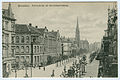
Historical view of Bödekerstrasse , around 1898

Demanding residential development on Bödekerstraße and Wedekindstraße
Yorckstraße, behind the Trinity Church (architect Christoph Hehl )
Apartment buildings built after the war damage


Current situation

The Lister Meile , a street partially designed as a pedestrian zone , which leads from the main station to Lister Platz, is characteristic of the eastern part of the city . At the intersection of Lister Meile and Hamburger Allee is the 91 meter high Bredero skyscraper . Opposite is the Pavillon cultural center . In addition to an event room for concerts, there is a district library, the theater workshop , rooms for workshops and adult education courses as well as the Café Mezzo. North of the pavilion is the White Kreuzplatz . The Gorlebenstein on the square is reminiscent of the Gorleben Trek . The 1.08 km long Bödekerstraße is one of the busiest streets in Oststadt and connects the district with the List .
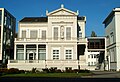
The listed Villa Seligmann of the former director of the Continental AG Siegmund Seligmann on the edge of the Eilenriede housed the music school of the city of Hanover until the beginning of 2008. After extensive renovation of the building, it is now the seat of the European Center for Jewish Music .
In 1999, the Rock Music Foundation acquired the former air raid shelter on Friesenstrasse and built practice rooms for music groups there. There is a primary school with a gym nearby.
Regular events are street festivals, the Christmas market on the Lister Meile and the world beat festival Masala in the pavilion. Every Thursday afternoon there is a weekly market on the Lister Meile between Sedanstrasse and Wedekindstrasse .
zoo

In the Zoo district (also known as the Zooviertel , more rarely the Hindenburgviertel ) is the eponymous Hanover Zoo . This is where the Hanover Congress Center and the city park are located , which was created on the site of the first Federal Horticultural Show in 1951. The entire northern part of the Eilenriede belongs to the district. Therefore, the Lister Tower is in the Zoo district and not in the List . The University of Music, Theater and Media has its headquarters at the New House .
There are two high schools in the district, the Sophia School and the Kaiser Wilhelm and Ratsgymnasium . The neo-Romanesque church of St. Elisabeth is located on Gellertstrasse . The former Jewish Hospital Hanover was also in the district.
The later Reich President Paul von Hindenburg lived in the Zoo district from 1919 to 1925, from which the name Hindenburgviertel was derived. The city of Hanover had made Hindenburg an honorary citizen and gave him a villa. The Hindenburgvilla is now the seat of the Fritz Behrens Foundation .
The Zooviertel is a preferred residential area with an upscale old building fabric with rents and property prices that are well above average.
District Council
In the local elections on September 11, 2011 , the Greens became the strongest party in the district for the first time with 31.7% of the vote and Norbert Gast is the district mayor. The SPD became the second strongest party (30.6%) and has Michael Sandow as the deputy district mayor. There is an agreement between the two parties that the SPD will propose the district mayor halfway through the legislative period. The Central District Council meets about eleven times a year in public in the New Town Hall .
literature
- Regine Schramm: In the heart of the city. The old town: housing misery and poverty , in Adelheid von Saldern et al. : Everyday life between Hindenburg and Haarmann. Another city guide through Hanover in the 20s , publisher: Geschichtswerkstatt Hannover, Hamburg: VSA-Verlag, 1987, ISBN 3-87975-397-0 , pp. 63-68
- Detlef HO Kopmann: Hanover-Oststadt. Sutton 2004, ISBN 3-89702-688-0 .
- Karl Friedrich Leonhardt : The beginnings of Hanover and the Calenberger Neustadt. In: City Archives Hannover (ed.): Hannoversche Geschichtsblätter . Vol. 30, 1927, pp. 146-240a.
- Wolfgang Neß among other things: Monument topography Federal Republic of Germany . Architectural monuments in Lower Saxony. City of Hanover. (Volume 10.1). Published by Hans-Herbert Möller, Lower Saxony State Administration Office - publications by the Institute for Monument Preservation, Friedr. Viehweg & Sohn, Braunschweig / Wiesbaden 1983, ISBN 3-528-06202-9 .
- Helmut Knocke , Hugo Thielen : Calenberger Neustadt. In: Hanover Art and Culture Lexicon . P. 98.
- Klaus Mlynek : Calenberger Neustadt. In: Klaus Mlynek, Waldemar R. Röhrbein (eds.) U. a .: City Lexicon Hanover . From the beginning to the present. Schlütersche, Hannover 2009, ISBN 978-3-89993-662-9 , p. 105 f.
Web links
- Page from Hannover on the renovation of the city center Hannover City 2020+
- City district portal center
- Structural data of the city districts and districts of Hanover as of 2020, a publication of the city of Hanover
- Calenberger Neustadt detail page
Individual evidence
- ↑ District 1: Mitte | District Councils | State capital Hanover | Political bodies | Politics | Living in the Hanover Region | Hannover.de | Home - hannover.de. Retrieved June 30, 2019 .
- ↑ Composition of the District Council , accessed on Aug. 22, 2018
- ^ Gisela Jaschik: March 1979: Gorleben trek to Hanover. (Video) In: North German History. ndr.de, accessed on March 22, 2011 .
- ^ Grotefend: Document book of the city of Hanover ; P. 400 + 491
- ↑ http://www.hannover-kist.de/abc/c.htm
- ↑ www.theater-an-der-glocksee.de
- ↑ a b c d e f Wolfgang Neß, Ilse Rüttgerodt-Riechmann, Gerd Weiß (ed.): Architectural monuments in Lower Saxony. 10.1. City of Hanover, Part 1. Friedrich Vieweg and Son, Braunschweig / Wiesbaden 1983. ISBN 3-528-06203-7 .
- ^ HAZ Stadt-Anzeiger West from November 24, 2011
Coordinates: 52 ° 22 ′ N , 9 ° 44 ′ E