Brandis (Schönewalde)
|
Brandis
City of Schönewalde
Coordinates: 51 ° 47 '52 " N , 13 ° 10' 42" E
|
|
|---|---|
| Height : | 81 m above sea level NHN |
| Residents : | 261 (December 31, 2016) |
| Incorporation : | December 31, 1998 |
| Incorporated into: | Heideeck |
| Postal code : | 04916 |
| Area code : | 035362 |
Brandis is a village in the Elbe-Elster district in the southwest of Brandenburg . The place is - since October 6, 2004 under the official name Brandis / Horst - a district of the city of Schönewalde . Brandis was an independent municipality until December 30, 1998; from December 31, 1998 to December 30, 2001, Brandis was part of the municipality of Heideeck .
location
Brandis is located around twelve kilometers north of Herzberg / Elster and 40 kilometers west of Luckau and east-southeast of Lutherstadt Wittenberg , right on the border with Saxony-Anhalt . Surrounding villages are the municipality of Horst in the north, Schmielsdorf and Schönewalde in the northeast, Grauwinkel in the east, Grassau in the southeast and the places Holzdorf-Ost in the south, Holzdorf in the southwest, Reicho in the west and Buschkuhnsdorf in the northwest.
The federal highway 101 runs through the town of Brandis . In addition, federal road 187 ends in Brandis , while state road 71 begins in town. Brandis is located immediately south of the Schweinitzer Fließ and therefore no longer in Fläming , while the northern part of the municipality Horst belongs to Fläming. The Holzdorf Air Base is located south of Brandis .
history
The place was first mentioned in 1380 as Brandicz . The name appears as a family name as early as 1212 and goes back to the Tyrolean noble family of the same name . The place name was probably transferred to the place from the city of Brandis near Leipzig .
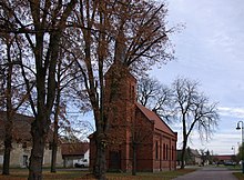
Brandis historically belonged to the Schweinitz office and was therefore part of the Duchy of Saxony-Wittenberg or the Electorate of Saxony at the time it was first mentioned . The place has been part of Schönewalde church since 1515. In 1806 the electorate was elevated to the Kingdom of Saxony . As a result of the division of the Kingdom of Saxony after the Congress of Vienna , Brandis came to the Kingdom of Prussia and there to the Province of Saxony , where the place was assigned to the district of Schweinitz in the administrative district of Merseburg during the territorial reform in the following year . In 1875 Brandis had 275 residents. In the years 1896/97 Brandis received its own village church, which was built in the neo-Romanesque style.
Since the dissolution of the province of Saxony on July 1, 1944, Brandis has belonged to the province of Halle-Merseburg . After the Second World War, Brandis came to the Soviet occupation zone and in 1949 to the GDR. Brandis has belonged to the state of Saxony-Anhalt since 1947 . The district of Schweinitz was renamed the district of Herzberg on July 1, 1950 . During the GDR district reform on July 25, 1952, the district of Herzberg and the state of Saxony-Anhalt were dissolved and Brandis came to the reduced district of Herzberg in the Cottbus district . On January 1, 1974, Horst was incorporated into Brandis. After reunification , the community of Brandis initially belonged to the Herzberg district in Brandenburg.
In September 1992, the community joined the office of Schönewalde to handle its administrative business . During the district reform of December 6, 1993, the district of Herzberg merged with the districts of Bad Liebenwerda and Finsterwalde in the new district of Elbe-Elster . On December 31, 1998, Brandis and the previously independent communities of Ahlsdorf and Stolzenhain merged to form the new community of Heideeck . The community of Heideck was again dissolved on December 31, 2001 and its districts incorporated into Schönewalde, whereupon the office of Schönewalde was dissolved. On October 6, 2004, the Brandis district was renamed Brandis / Horst .
Population development
|
|
|
|
Territory of the respective year, from 1981 with Horst
Web links
- Brandis on the side of the town of Schönewalde
Individual evidence
- ↑ Community and district directory of the state of Brandenburg. Land surveying and geographic base information Brandenburg (LGB), accessed on August 1, 2020 (Note: With Horst).
- ↑ Reinhard E. Fischer : The place names of the states of Brandenburg and Berlin. Age - origin - meaning. be.bra, Berlin 2005, p. 32.
- ^ Brandis village church, Schönewalde-Brandis. In: kulturkirchen.org , accessed on August 1, 2020.
- ↑ Historical municipality register of the state of Brandenburg 1875 to 2005. (PDF; 331 kB) District Elbe-Elster. State Office for Data Processing and Statistics State of Brandenburg, December 2006, accessed on August 1, 2020 .
