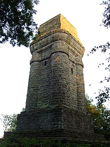
Brasselsberg (Habichtswald)
| Brasselsberg | ||
|---|---|---|
|
The Brasselsberg seen from the Dönche |
||
| height | 434.2 m above sea level NHN | |
| location | in Kassel - Brasselsberg ; North Hesse ( Germany ) | |
| Mountains | High hawk forest | |
| Coordinates | 51 ° 17 '26 " N , 9 ° 24' 25" E | |
|
|
||
| particularities | Kassel Bismarck Tower | |


The Brasselsberg in the area of the Kassel district Brasselsberg is 434.2 m above sea level. NHN high, wooded mountain spur on the eastern flank of the Hohen Habichtswald in northern Hesse . It is the location of the Kassel Bismarck Tower .
geography
location
The Brasselsberg is located in the east of the Habichtswald Nature Park high above the Brasselsberg district in the southwest of Kassel . The mountain ridge that leads from the mountain spur to the actual Hohe Habichtswald meets the Bilstein cliffs in the west near the Porta Lapidaria rock gate . To the north and east past the mountain flows the north house Mühlbach and south of its tributary Pangesgraben . The seven ponds are located southwest of the mountain . The neighboring mountains are the Kuhberg ( 539 m ) in the north-west, the Hirzstein ( 502 m ) in the west- south- west and the Baunsberg ( 413.4 m ) in the south.
Parts of the fauna-flora-habitat area Habichtswald and Seilerberg near Ehlen (FFH no. 4622-302; 29.19 km² ) are located on the mountain .
Natural allocation
The Brasselsberg belongs to the natural spatial main unit group West Hessisches Bergland (No. 34), in the main unit Habichtswälder Bergland (342) and in the subunit Habichtswald (with Langenberg) (342.0) to the natural area Hoher Habichtswald (342.00). To the southwest the landscape falls into the natural area Hoofer Pforte (342.01) and to the east into the subunit Kassel Basin (343.3) belonging to the main unit West Hessian Basin (343) .
Colliery Marie
In the transition area to Cow Mountain was in the little north Bilstein cliffs on forest road Colliery Marie-way lying Zeche Marie 1868-1966 underground lignite mined.
Kassel Bismarck Tower
Near the Brasselsberg summit stands the Kassel Bismarck Tower , which was inaugurated in 1904 and with a height of 25.5 m is the highest of 47 Bismarck columns designed according to the "Götterdämmerung" design. Its viewing platform offers a view especially over Kassel and the mountain ranges and low mountain ranges around the Kassel Basin Reinhardswald , Kaufunger Wald , Söhre , Langenberge and Hoher Habichtswald .
Traffic and walking
Earlier
On a side track of the Herkulesbahn , a meter-gauge railway operated from 1902 to 1966 with goods and passenger traffic in the Kassel city area and Hohen Habichtswald, from 1911 to 1965 passenger railcars drove from the Luisenhaus on Druseltalstrasse along the Habichtswald on Bergstrasse (today Konrad-Adenauer-Strasse ) to the terminus at Brasselsberg . On November 30, 1965, a railcar ran this route for the last time; on December 1, 1965, the company switched to bus operation.
today
East past the Brasselsberg, the Konrad-Adenauer- Strasse, coming from the Kassel- Bad Wilhelmshöhe junction of the federal motorway 44 , leads in a south-north direction to the Druseltalstrasse , both of which are part of the 3218 state road . From the parking lots on this road, forest paths lead steeply up to the crest. The Kassel-Steig runs over the mountain and the Ederseeweg over its south and east flanks .
Individual evidence
- ↑ a b c Map services of the Federal Agency for Nature Conservation ( information )
- ^ Hans-Jürgen Klink: Geographical land survey: The natural space units on sheet 112 Kassel. Federal Institute for Regional Studies, Bad Godesberg 1969. → Online map (PDF; 6.9 MB)
- ↑ a b Bismarck Tower Kassel , on bismarcktuerme.de

