
Upper Palatinate lignite district
The Bohemian brown coal district was a mining area in the Upper Palatinate , in the 19th and 20th centuries, mainly in surface mining , lignite was promoted.
Origin of brown coal
At the time of the Miocene , the Molasse basin between the Danube and the Alps sank, with Eastern Bavaria being raised relative to it. Between Pfreimd and Regensburg the Ur-Naab and its tributaries dug deep channels into the basement . When these valleys were filled with gravel , sand and clay, extensive swamp forests emerged in the subtropical climate in the silting branches and oxbow lakes . The remains of these forests were repeatedly covered by sediments . This created alternating layers of organic material, clays , sand and later gravel. Due to the exclusion of air and the pressure of the overlying sediments, the organic material was converted into coal over time .
History of coal mining


Wackersdorf area
In 1800, master tailor Andreas Schuster came across lignite while excavating a well in Wackersdorf . Coal production in underground mining developed on a comparatively modest scale, which was discontinued as early as the 1840s. Only at the beginning of the 20th century was mining resumed, but this time as an open pit . In 1904 the Bavarian lignite and briquette industry union Klardorf was founded, which was merged on February 5, 1906 in the Bayerische Braunkohlen Industrie AG (BBI). This was initially based in Münster in Westphalia , and from March 4, 1908 in Schwandorf .
A briquette factory was built in Wackersdorf in 1908 and expanded several times. For the production of briquettes, particularly low-ash coal was necessary. When the deposits of this coal were exhausted, the briquette factory was closed in 1964 and blown up in the following years. About a year before the closure, production was around 175,000 tons per year. A total of around 5.7 million tons of briquettes were produced there.
In 1930 the Schwandorf coal-fired power station in the Dachelhofen district went into operation. Until coal production was discontinued in 1982, the power plant was supplied with fuel from the Wackersdorfer district by the company's own railway . From 1982 until the power plant was closed in 2002, Czech hard lignite was imported for the power plant.
Already in the 1920s it was planned to relocate the place Wackersdorf in order to be able to extract the brown coal underneath. However, this project initially failed. Planning was only resumed after the Second World War. Between 1950 and 1952, the move from Wackersdorf to its current location took place.
In 1962, another coal field was developed in the Rauberweiherhaus district of Wackersdorf.
In 1982 the economically viable coal reserves in the Upper Palatinate Revier were exhausted. On September 21, 1982 the last ton of coal was mined. BBI was dissolved on September 30th, and Bayernwerk AG became the legal successor .
A total of around 185 million tons of lignite were mined in the area around Wackersdorf. It was the second largest lignite mining area in what was then the Federal Republic of Germany after the Rhenish lignite mining area .
Maxhütte-Haidhof
In the 1830s, lignite was also discovered in the area of today's Maxhütte-Haidhof (district of Ponholz). From 1853 it was used for steel production in the newly built Maxhütte , but because of the high water and clay content it was soon replaced by Bohemian coal .
In 1907 a briquette factory was opened in Haidhof-Ponholz. However, because of the poor quality of the coal, briquette production was not profitable. It was therefore decided to build a coal-fired power station that would not only supply the surrounding communities, but also deliver electricity to Regensburg. On June 12, 1908, the Bavarian overland headquarters was founded. The power plant went into operation in April 1910. However, in the 1920s it became increasingly uneconomical. On March 31, 1931, one year after the Schwandorf-Dachelhofen power plant went into operation, the BÜC power plant was shut down. OBAG later emerged from the company .
The pits were later also used for the extraction of clay.
regensburg
In Regensburg, lignite and clay have been mined in the Friedrich-Zeche in the Dech Betten district since 1903 , initially underground, then in open-cast mining. The nearby brick factory was in operation until 1997. The lignite was used as an aggregate for brick production and as fuel. The colliery was taken over by Gerhard Rösl GmbH & Co. KG and is still in operation today, a dismantling permit is available until 2029. In addition to lignite and clay, rocks, sand and earth are now mined and excavated earth and rubble are stored. Today, lignite is also marketed as a soil substrate as an alternative to bark mulch .
Pettendorf
In Kneiting , which at that time was still independent and only came to Pettendorf as part of the municipal reform in 1978 , lignite was already being mined in 1834. After the Second World War, due to the shortage of fuel, increased attempts were made to use domestic energy sources. Two locations north and south of Schwetzendorf also appeared to be worth mining. While a pure opencast mine was built north of Schwetzendorf, the Reifenthal mine was divided into two parts south of Schwetzendorf - an opencast mine was built in the southern part, while underground mining took place to the north. Funding began in October 1948. Since the supply situation improved rapidly, the mining of the relatively inferior brown coal near Schwetzendorf soon became unprofitable, so that the production had to be stopped again in February 1950. With a length of 240 meters and a width of 70–80 meters, the mine was only about a quarter of the size originally planned.
Reuse
Most of the former opencast mines were flooded if they were not filled with overburden. In the area around Wackersdorf, six larger open-cast mining lakes were created with a total water surface of approx. 650 hectares , today's Upper Palatinate Lake District . The west field north-west of the Steinberger See , which was used as a landfill for ash from the power plant in Dachelhofen and as a coal store until 2002, is currently part of a recultivation measure that is to be completed by the end of 2022. However, there are currently no concrete plans for re-use.
Several BBI civil servant houses in Wackersdorf are under monument protection.
The former administration building of the BBI was converted into an office building.
On June 17, 2015, the Wackersdorfer municipal council decided against the votes of the mayor and two other council members to demolish the former community center of the BBI and replace it with a new event hall.
The mine of the Reifenthal mine is now a popular local recreation area as Schwetzendorfer Weiher .
Museum processing
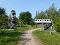
The history of lignite mining in the Wackersdorfer Revier is presented today in two museums, the local history and industry museum in Wackersdorf in the former laboratory building of the BBI and the local history and lignite museum in Steinberg am See . Both museums are connected by a 3.5 km long educational museum trail and are part of the North Bavarian Industriestraße .
Not far from the Wackersdorfer Museum, a tertiary forest was created with woody trees that were already growing here at the time of today's brown coal. Various large exhibits can also be viewed on the site, such as railway wagons, excavator shovels or the runner of a steam turbine from the power plant in Dachelhofen.
At the entrance to Maxhütte-Haidhof, a wooden headframe is a reminder of the importance of mining for the history of the city.
In 2004, in Regensburg, on the edge of the Friedrich-Zeche, the Rösl company, in cooperation with the University of Regensburg, laid out an educational trail for geology, landscape and raw material mining with a total length of 450 meters. A tertiary forest has also been planted here. There is also a field railway museum here .

Old briquette press exhibited in Wackersdorf
Various exhibits in the tertiary forest in Wackersdorf
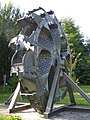
Bucket wheel of a lignite excavator

Runner of a low-pressure steam turbine at the Dachelhofen power plant

Tram of the former chain railway

Various exhibits in front of the museum in Steinberg am See

Conveyor belt in front of the museum in Steinberg am See


Meaning as geotopes
Near the Wackersdorfer Museum there is a viewing platform on the edge of the western field , from which visitors can view exposed brown coal seams . This outcrop is counted among the 100 most beautiful geotopes in Bavaria by the Bavarian State Office for the Environment .
Friedrich-Zeche opencast mine
The Friedrich-Zeche open-cast mine has been designated as an important geotope by the Bavarian State Office for the Environment (Geotope number: 362G001).
Open-cast brown coal mine near Wackersdorf
The open-cast lignite mine near Wackersdorf has been designated as a valuable geotope (geotope number: 376A031) by the Bavarian State Office for the Environment.
Former Rauberweiher lignite mine field
The former Rauberweiher lignite mine field has been designated as an important geotope by the Bavarian State Office for the Environment (geotope number: 376G001).
See also
- List of geotopes in Regensburg
- List of geotopes in the Schwandorf district
- List of the most beautiful geotopes in Bavaria
literature
- Bavarian State Office for the Environment (Ed.): Hundred masterpieces - The most beautiful geotopes in Bavaria , 2012, ISBN 978-3-936385-89-2
- W. Scharf: The lignite from Schwandorf (Upper Palatinate) and its mining in: Journal of the German Geological Society , Volume 106 (1954), pp. 538-567
Movies
- Tertiary heirs - the rise of a rural region to a modern industrial location , 85 min. (2013)
Web links
- Wackersdorfer lignite (display board of the Bavarian State Office for the Environment) (pdf)
- Wackersdorf Local History and Industry Museum at oberpfaelzer-seenland.de
- Local history and lignite museum Steinberg am See on oberpfaelzer-seenland.de
- Wackersdorf Local History and Industry Museum on the website of the Wackersdorf administrative association
- Local history and lignite museum Steinberg am See on the website of the administrative community Wackersdorf
- 100 years ago: Bayerische Überlandcentrale Ponholz - company forerunner of OBAG on www.onetz.de
- Andreas Christopher: Lignite mining and works railways in the Wackersdorf district , in: Bahn-Express 6'84 (PDF)
- Flyer "Nature trail for geology, landscape and raw material mining in the Friedrich-Zeche in Regensburg" (pdf)
- Friedrich-Zeche Feldbahn-Museum
Individual evidence
- ↑ Dr. G. Pedall Ing.-Büro GmbH: Investigation of the former Bavarian Brown Coal Industry AG in Wackersdorf (PDF)
- ^ History and development of Wackersdorfer lignite mining before the establishment of the BBI
- ↑ Former lignite mine in the Upper Palatinate Lake District
- ↑ Engelbert Weiß: Lignite should replace agricultural chemistry on www.mittelbayerische.de, September 29, 2015
- ↑ Chronicle at www.kneiting.de
- ^ Westfeld Wackersdorf: 12 million for recultivation. Retrieved August 18, 2019 .
- ↑ List of monuments for Wackersdorf of the Bavarian State Office for Monument Preservation
- ↑ Kathrin Bayer: A piece of history filled with new life on www. Mittelbayerische.de, May 5, 2009
- ↑ Johann Ippisch: A piece of BBI history must give way to www. Mittelbayerische.de, June 18, 2015
- ↑ Museum trail on the website of the local history working group Steinberg am See
- ↑ Nature trail for geology, landscape and raw material mining in the Friedrich-Zeche in Regensburg / Dech Betten ( memento of the original from April 3, 2016 in the Internet Archive ) Info: The archive link was automatically inserted and not yet checked. Please check the original and archive link according to the instructions and then remove this notice. on www.roesl.de
- ↑ Feldbahn-Museum Friedrich-Zeche
- ^ Wackersdorfer brown coal on the website of the Bavarian State Office for the Environment
- ↑ Bavarian State Office for the Environment, Geotop open-cast mine Friedrich-Zeche near Dech Betten (accessed on October 16, 2017).
- ↑ Bavarian State Office for the Environment, Geotop brown coal opencast mine S von Wackersdorf (accessed on October 16, 2017).
- ↑ Bavarian State Office for the Environment, Geotope Former brown coal mine field "Rauberweiher" (accessed on October 16, 2017).
Web links
Coordinates: 49 ° 16 ′ 44.4 " N , 12 ° 9 ′ 46.8" E