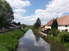
Bruche (river)
| Breaks | ||
|
Course of the fractures |
||
| Data | ||
| Water code | FR : A2-0110 | |
| location |
Vosges
|
|
| River system | Rhine | |
| Drain over | Ill → Rhine → North Sea | |
| source | on the western slope of Climont 48 ° 20 ′ 40 ″ N , 7 ° 10 ′ 1 ″ E |
|
| Source height | 670 m | |
| muzzle | near Strasbourg in the Ill coordinates: 48 ° 34 ′ 3 ″ N , 7 ° 42 ′ 45 ″ E 48 ° 34 ′ 3 ″ N , 7 ° 42 ′ 45 ″ E |
|
| Mouth height | 130 m | |
| Height difference | 540 m | |
| Bottom slope | 7 ‰ | |
| length | 76.8 km | |
| Catchment area | 727.3 km² | |
| Drain at the mouth |
MQ |
7.9 m³ / s |
| Left tributaries | Chergoutte , Wackenbach , Netzenbach , Hasel , Mossig | |
| Right tributaries | Magel | |
| Big cities | Strasbourg | |
| Small towns | Mutzig , Molsheim , Lingolsheim , Eckbolsheim | |
| Communities | Schirmeck | |
|
The Canal de la Bruche near Wolxheim |
||
The Bruche ( German Breusch , Alsatian Brisch ) is a river in the Bas-Rhin department in the Grand Est region . It is a left tributary of the Ill .
geography
course
The Breusch rises in the Vosges and flows through Alsace before flowing into the Ill after almost 77 km . Its source is on the Climont in the municipality of Saales . The Breuschtal is one of the longest valleys in the Vosges. At Mutzig , the Breusch enters the Upper Rhine Plain from the Vosges through the chain of foothills . It flows into the Ill near Gliesberg, a south-western suburb of Strasbourg .
Backwaters of the Bruche
The Hasel and the Mossig are two of several tributaries of the Breusch and have shaped the landscape of this area. Its valleys border the largest forest massif in the Central Vosges . The Mutzigfelsen (1010 m) in the south and the Schneeberg (961 m) in the north tower over this region.
Breusch Canal

At Avolsheim , near the confluence of the Mossig north of Molsheim , part of the Breusch is directed into the Breusch Canal ( Canal de la Bruche ), which runs parallel to the north . The canal was laid after the annexation of the city of Strasbourg by Louis XIV. In 1681. The king had the engineer Vauban convert the city into a fortress with ramparts and bastions from 1682 according to the latest knowledge at the time. In order to be able to bring the required material from quarries in the Vosges to Strasbourg more easily, Vauban first dug this canal. The 19.78 km long canal with 11 locks flows into the Ill a few hundred meters north of the mouth of the Breusch . Until 1939 it was used as a waterway for the transport of civil goods such as timber, wine and bricks. After the war, destroyed bridges were rebuilt so low that the canal can no longer be used by barges.
A large part of the Itinéraire cyclable européen (European cycle route) Molsheim –Strasbourg – Kehl– Offenburg runs along the Breusch Canal .
Hydrology
At the confluence of the Breusch in the Ill , the mean flow rate (MQ) is 7.9 m³ / s; the catchment area here covers 727.3 km².
At the Holtzheim gauge , the average annual runoff from the Breusch was calculated over a period of 46 years (1965–2010). The catchment area at this point, at 548 km², corresponds to about 75% of the entire catchment area of the river.
The highest water levels are measured between December and March. The flow rate reached its peak in February with 14.8 m³ / s. From April onwards, the discharge drops noticeably month after month and reaches its lowest level in August with 2.25 m³ / s, after which it increases again from month to month. The annual average value is 8.14 m³ / s.
The monthly mean discharge (MQ) of the Breusch in m³ / s, measured at the hydrological station Holtzheim.
Data from the values for the years 1965–2010 calculated

fauna
The following fish species are found in the Breusch: brown trout , chub , hazel , roach , gudgeon , tailor , minnow and brook lamprey .
Individual evidence
- ↑ Bruche at SANDRE (French)
- ↑ see web link: Débits caractéristiques de la Bruche
- ↑ Débits caractéristiques de la Bruche
- ^ Johann Andreas Silbermann, Local History of the City of Strasbourg , Strasbourg 1775 (Google Book Search)
- ↑ Banque Hydro - A2860110 La Bruche à Holtzheim (menu item: Synthèse)
- ↑ The Bruche


