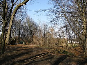
Burgstall Alling
| Burgstall Alling | ||
|---|---|---|
| Castle type : | Hilltop castle | |
| Conservation status: | Burgstall | |
| Place: | Eichenau - Alling | |
| Geographical location | 48 ° 8 '27 " N , 11 ° 17' 42" E | |
| Height: | 560 m above sea level NN | |
|
|
||
The Postal Alling is an Outbound high medieval hilltop castle on 560 m above sea level. NN about 230 meters west of the parish church of the Birth of Mary in Alling ( Fürstenfeldbruck district in Upper Bavaria ) above the Starzelbachtal . The former aristocratic seat is freely accessible, but was partially destroyed by gravel mining.
history
The partially preserved double moat of the site monument could indicate an early medieval predecessor castle. Perhaps the Burgplatz served as a refuge for the rural population back then. Staggered wall systems of this type are often interpreted as being from the Hungarian period . The Magyar archers should be kept at a distance. In the local history literature, the function as Carolingian Curtis is considered. The place appears as Alingas in a document as early as 802 .
However, early medieval fasteners were used until the early High Middle Ages. The local nobility of Alling only becomes apparent in the written sources around 1150. The size of the castle means that the Allinger family is likely to have a noble origin. Like many non-noble people, however, the village patrons soon submitted to a more powerful patron.
In the contemporary sources, various Allingers are named as the Schäftlarn monastery liable for interest, i.e. they had joined the monastery familia . In the documents appear u. a. Messrs. Konrad , Sigboto , Arnold , Gerold , Perchtold , Diemot and Waldmann von Alling as ministerials of the monastery.
In the castle area, no stone or brick rubble can be found above ground. The castle stables were probably abandoned as early as the High Middle Ages. Since then, the parish church of the village has risen in place of the Allinger's own church .
It is possible that the road connection between Augsburg and Munich was controlled from the castle . This road ran north of Alling since the High Middle Ages.
In 1422 the battle of Alling was fought nearby . This conflict between the dukes of Bayern-Munich and Bayern-Ingolstadt is said to have been relatively peaceful. Few warriors were killed, but many were taken prisoner. Alling Castle was certainly long deserted by then.
The southern part of the core castle was completely removed by gravel mining until modern times. The terrain here drops very steeply into the Starzelbachtal today. The Flurname Weinberg suggests a former wine growing out of this south-facing slope.
The area between the parish church and the main castle has largely served as a cemetery since the Middle Ages.
description
The Burgstall is located on a tongue of land running to the west above Alling. To the south, a steep slope up to 30 meters high protects the Burgplatz. In the north, a ravine separates the castle complex from the adjoining high plateau.
The unusual size of the entire facility speaks for the noble origin of the gentlemen von Alling. In total, the castle was about 300 meters long and was probably protected in the east by a section ditch, which is, however, completely leveled. The Allinger church was located on the eastern tip of the Geländesporn.
The main castle lay over the south-western slope edge. Due to the gravel mining, only the northwest part has been preserved. The doubling of the northern rift system is unusual . The outer trench is up to four meters deep, the inner trench about one meter. Between the trenches a ridge of earth was heaped up or left standing.
In the west of the main castle cone there is no intermediate wall, the moat is accordingly over 15 meters wide. With the trench excavation, the earth cone of the inner castle was raised like a moth . The plateau towers over the surrounding area by about two meters. The castle hill was probably originally square or rectangular. Whether a tower or a house or tower house stood here in the High Middle Ages is speculative.
The spacious outer bailey with the former own church has been heavily changed and leveled through the conversion to a cemetery and partly as an agricultural area. Clear terrain features of a building or fortification can no longer be determined here. The northern ravine is paved and allows access to the parking lot of the parish church and the cemetery. The cemetery path leads through the Gottesacker to the castle stable, which is completely wooded and has a small Lourdes grotto .
The Bavarian State Office for Monument Preservation lists the ground monument as a medieval castle stables under monument number D-1-7833-0087.
Southeast of the valley on the Parsberg lies the high mediaeval Burgstall Parsberg .
literature
- Alling community (ed.): 1200 years of Alling: 802–2002 . Alling 2002.
- Volker Liedke, Peter Weinzierl: Fürstenfeldbruck district (Monuments in Bavaria, Volume I.12). Munich 1996, ISBN 3-87490-574-8 .
- Hans H. Schmidt (Working Group for Local History Research in the Würm Region): “Sunken castles” in the five-lake region between Ammersee and Isar - historical and archaeological reconstructions . Gauting 2002.
Web links
Individual evidence
- ↑ Bavarian State Office for Monument Preservation: Entry ( Memento of the original from March 4, 2016 in the Internet Archive ) Info: The archive link was inserted automatically and has not yet been checked. Please check the original and archive link according to the instructions and then remove this notice.


