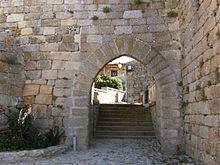
Castelo Bom
| Castelo Bom | ||||||
|---|---|---|---|---|---|---|
|
||||||
| Basic data | ||||||
| Region : | Centro | |||||
| Sub-region : | Beiras e Serra da Estrela | |||||
| District : | Guarda | |||||
| Concelho : | Almeida | |||||
| Coordinates : | 40 ° 37 ′ N , 6 ° 54 ′ W | |||||
| Residents: | 216 (as of June 30, 2011) | |||||
| Surface: | 25.04 km² (as of January 1, 2010) | |||||
| Population density : | 8.6 inhabitants per km² | |||||
| Postal code : | 6355-042 Castelo Bom | |||||
| politics | ||||||
| Mayor : | António dos Santos Fernandes | |||||
| Address of the municipal administration: | Junta de Freguesia de Castelo Bom 6355-030 Castelo Bom 6355-042 Castelo Bom Castelo Bom |
|||||
Castelo Bom is a municipality ( freguesia ) in the Portuguese district of Almeida . It has 216 inhabitants (as of June 30, 2011).
geography
Castelo Bom is about 14 km from the district town of Almeida and about 35 km from the district capital Guarda .
history
King Alfonso VIII (Castile) granted the place its first city rights in the 12th century. After the definitive conquest of the place by the independent Kingdom of Portugal and shortly before the conclusion of the Treaty of Alcañices (1297), Castelo Bom received city rights ( Foral ) by King D. Dinis in 1296 , which were renewed by Manuel I in 1510 . Until 1834 it was the seat of an independent district ( concelho ), and has since belonged to the Almeida district.
Culture, sports and sights
Its numerous listed buildings include various mansions , fountains and churches. The castle complex from the 13th century with various extensions from later epochs should be mentioned here in particular.
The location was shortlisted for the Aldeias Históricas de Portugal project , a program launched in 1998 to preserve and promote historic villages with diverse and well-preserved buildings. It was not included because the initial phase was limited to ten locations. Since then, a citizens' initiative has endeavored to include Castelo Bom in the program, which, in addition to conditions, also includes special funding and marketing measures .
Castelo Bom is a place for international geocaching search game fans.
Population development
| Population of Castelo Bom 1864-2001 | ||||||||||||||
|---|---|---|---|---|---|---|---|---|---|---|---|---|---|---|
| 1864 | 1878 | 1890 | 1900 | 1910 | 1920 | 1930 | 1940 | 1950 | 1960 | 1970 | 1981 | 1991 | 2001 | 2011 |
| 317 | 373 | 397 | 456 | 519 | 474 | 429 | 510 | 562 | 484 | 268 | 203 | 193 | 181 | 216 |
administration
Castelo Bom is the seat of a municipality of the same name. The neighboring municipalities are (starting clockwise in the north): Naves , São Pedro de Rio Seco , Vilar Formoso , Freineda , Castelo Mendo , Mido , and Senouras .
The municipality consists of the following localities:
- Castelo Bom
- Aldeia de Sao Sebastiao.
traffic
Castelo Bom is on the Linha da Beira Alta railway line , with its Aldeia train station (Aldeia de São Sebastião). It is also on the A25 motorway , between the Alto de Leomil and Vilar Formoso exits .
Web links
Individual evidence
- ↑ a b www.ine.pt - indicator resident population by place of residence and sex; Decennial in the database of the Instituto Nacional de Estatística
- ↑ Overview of code assignments from Freguesias on epp.eurostat.ec.europa.eu
- ↑ www.cm-almeida.pt ( Memento of the original dated February 8, 2011 in the Internet Archive ) Info: The archive link was inserted automatically and has not yet been checked. Please check the original and archive link according to the instructions and then remove this notice. , accessed November 16, 2012
- ↑ www.monumentos.pt , accessed on November 16, 2012
- ↑ ditto
- ↑ www.causes.com , accessed November 16, 2012
- ↑ www.geocaching.com , accessed November 16, 2012


