Clintonville, Wisconsin
| Clintonville | ||
|---|---|---|
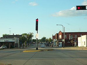
 Downtown Clintonville |
||
| Location in Wisconsin | ||
|
|
||
| Basic data | ||
| Foundation : | 1879 (inc.) | |
| State : | United States | |
| State : | Wisconsin | |
| County : | Waupaca County | |
| Coordinates : | 44 ° 37 ′ N , 88 ° 45 ′ W | |
| Time zone : | Central ( UTC − 6 / −5 ) | |
| Residents : | 4,559 (as of 2010) | |
| Population density : | 418.3 inhabitants per km 2 | |
| Area : | 11.1 km 2 (about 4 mi 2 ) of which 10.9 km 2 (about 4 mi 2 ) is land |
|
| Height : | 248 m | |
| Postal code : | 54929 | |
| Area code : | +1 715 | |
| FIPS : | 55-15725 | |
| GNIS ID : | 1563198 | |
| Website : | www.clintonvillewi.org | |
| Mayor : | Judith I. Magee | |
 US 45 and WIS 22 meet in downtown Clintonville |
||
Clintonville is a small town (with the status " City ") in Waupaca County in the US -amerikanischen State Wisconsin . In 2010 , Clintonville had 4,559 residents.
geography
According to the United States Census Bureau , the city has a total area of 11.1 km², of which 0.2 km² (1.8%) falls on water. In the western part of the city lies Pigeon Lake, the Pigeon River flowing through the lake meanders through the city in an east-west direction. Clintonville is mainly surrounded by fields.
Neighboring towns to Clintonville are Embarrass (7.2 km northeast), Bear Creek (12 km southeast), and Marion (12.5 km west-northwest).
The nearest major cities are Green Bay on Lake Michigan (65.5 km east-southeast), Appleton (60 km southeast), Wisconsin's largest city Milwaukee (206 km southeast), Chicago in Illinois (355 km in the same direction), Wisconsin's capital Madison ( 211 km southwest), Eau Claire (247 km west), the Twin Cities in Minnesota (370 km in the same direction), Wausau (91 km northwest), Duluth on Lake Superior in Minnesota (452 km in the same direction) and Sault Ste. Marie in the Canadian province of Ontario (505 km northeast, across from Sault Ste. Marie, Michigan ).
traffic
Road traffic:
| US 45 south to New London , north to Wittenberg . | |
| WIS 156 eastwards to WIS 29 | |
| WIS 22 north to Shawano and south first on the US-45 to Waupaca. |
All other roads are subordinate country roads, some unpaved roads and inner-city connecting roads.
With the Clintonville Municipal Airport there is a small airfield in the southeast of the city area. The nearest commercial airports are Austin Straubel International Airport at Green Bay (65 km east-southeast), Outagamie County Regional Airport at Appleton (54 km southeast) and Central Wisconsin Airport at Wausau (83 km west-northwest).
Economy and Infrastructure
car industry
The "Four Wheel Drive Auto Company", better known as "Four Wheel Drive" or simply "FWD" was founded in Clintonville in 1909 as the "Badger Four-Wheel Drive Auto Company" by Otto Zachow and William Besserdich. In 1908, Zachow and Besserdich developed the first four-wheel drive car, the so-called " battleship ". Its success led to the establishment of the company. "Badger" was eventually removed from the company name in 1910. Since 1958 the company has been called "FWD Corporation".
Airlines
Historically, Clintonville's airport is the birthplace of Wisconsin Central Airlines , which was founded in 1944 and developed into North Central Airlines and later into Republic Airline . In 1986 Republic was bought by Northwest Orient Airlines and became known as Northwest Airlines . In 2008 this merged with Delta Air Lines .
media
The Clintonville Chronicle was founded in 2009.
population
According to the 2010 census , Clintonville had 4,559 people in 2002 households. The population density was 418.3 people per square kilometer. In the 2002 households there were statistically 2.24 people each.
The racial the population was composed of 95.6 percent white, 0.3 percent African American, 1.1 percent Native American, 0.4 percent Asian and 0.9 percent from other ethnic groups; 1.7 percent were descended from two or more races. Hispanic or Latino of any race was 3.3 percent of the population.
24.4 percent of the population were under 18 years old, 56.7 percent were between 18 and 64 and 18.9 percent were 65 years or older. 52.4 percent of the population were female.
The average annual income for a household was 35,395 USD . The per capita income was $ 18,465. 21.4 percent of the population lived below the poverty line.
Known residents
- Dick Bennett , basketball coach
- Jean Hundertmark , 2006 Republican candidate for governor
- Daniel V. Speckhard , diplomat
Individual evidence
- ↑ a b American Fact Finder. Retrieved September 10, 2014
- ↑ Distance information according to Google Maps. Accessed on September 10, 2014
- ↑ City of Clintonville - Airport ( Memento of the original from September 10, 2014 in the Internet Archive ) Info: The archive link was inserted automatically and has not yet been checked. Please check the original and archive link according to the instructions and then remove this notice. Retrieved September 10, 2014
- ↑ AirNav.com - Clintonville Municipal Airport Accessed on September 10, 2014
