
Dallol Bosso
| Dallol Bosso | ||
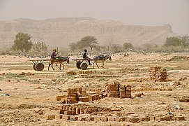
.jpg) Dallol Bosso, west of Filingué |
||
| Data | ||
| location |
|
|
| River system | Niger | |
| Drain over | Niger → Gulf of Guinea | |
| origin |
Azawad 15 ° 22 ′ 36 ″ N , 3 ° 22 ′ 8 ″ E |
|
| muzzle |
Boumba coordinates: 12 ° 24 ′ 38 " N , 2 ° 49 ′ 40" E 12 ° 24 ′ 38 " N , 2 ° 49 ′ 40" E
|
|
| length | 350 km | |
| Big cities | Tagazar , Tondikandia | |
The Dallol Bosso is a 350 kilometer long wadi in the west of Niger . It runs from the border with Mali in the north to the border with Benin in the south, where it flows into the Niger River.
course
The wadi has its origin in the branched Azawagh river system in the Gao region of Mali. From the state border with Niger, it bears the name Dallol Bosso. Dallol is a word from the Fulfulde language and means "valley". There are several Dallols in Niger, including the Dallol Foga and Dallol Maouri further east .
The Dallol Bosso initially runs in the Filingué department in Niger through the municipalities of Abala , Filingué , Kourfeye Center , Imanan , Tondikandia and Tagazar , where it includes a side valley coming from Banibangou . After Tagazar, the wadi reaches the Boboye department . The name Boboye comes from the Zarma language , also means "valley" and is another name for the Dallol Bosso. After the municipalities of Koygolo , Kiota , Harikanassou and N'Gonga , the Dallol Bosso Birni reaches N'Gaouré , the capital of the Boboye department. It then runs through the municipalities of Fabidji , Guilladjé and Falmey , where it flows into the Niger River near the village of Boumba opposite the state border with Benin.
On its way the Dallol Bosso crosses two large landscapes: the Sahel zone and the large Sudan landscape .
Characteristics and use
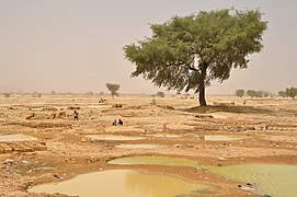
The hydromorphic soils in the valley floor are rich in clay and organic matter. The water table is high. There are good conditions here for irrigation field management . At the foot of the plateaus on both sides of the Dallol there are silt and clay soils that are exposed to erosion by wind and water. Grain is grown on the plateaus themselves.
In Dallol Bosso, the population density is high compared to the surrounding area, reaching more than 100 inhabitants per square kilometer. Land use conflicts often arise. The valley is a traditional settlement area of the Fulbe , which they share with other ethnic groups such as the Tuareg and Zarma .
The Dallol Bosso has been a Ramsar area since 2004 . This extends over an area of 376,162 hectares and is therefore the second largest of the twelve Ramsar areas of Niger after the Gueltas and oases of the Aïr .
- Traditional clay brick production in the Dallol Bosso


,_Dallol_Bosso.jpg)
,_brick_making.jpg)
,_brick_making.jpg)
,_brick_making.jpg)
,_brick_making.jpg)
literature
- C. Armand: Evaluation des ressources en eau du dallol Bosso. Report de factibilité hydrogéologique . BRGM, Orléans 1986.
- Alain Beauvilain: Les Peul du Dallol Bosso . Institut de Recherche en Sciences Humaines, Niamey 1977, ISBN 2-85921-042-3 .
- Elizabeth Nathalie Bui: Relationships between Pedology, Geomorphology and Stratigraphy in the Dallol Bosso of Niger, West Africa . Dissertation. Texas A&M University, 1986.
- Hima Issa Djibrilla: Etat actuel de l'arboriculture fruitière dans le Dallol Bosso . Faculté d'Agronomie, Université Abdou Moumouni, Niamey 1995.
- Kadidjatou Hamadou Harouna: Contribution de la femme dans l'économie du ménage en milieu agropastoral dans le Boboye (Dosso) . Faculté d'Agronomie, Université Abdou Moumouni de Niamey, Niamey 2013.
- Mariama Nouhou Koucha: Le palmier doum (Hyphaene thebaïca Mart.) Et les ressources pastorales du Dallol Bosso . Faculté d'Agronomie, Université Abdou Moumouni de Niamey, Niamey 2008.
- Saibou Soumana: Le Boboye, an exemple de développement de la petite irrigation au Niger (Sahel) . Éditions universitaires européennes, Saarbrücken 2017, ISBN 978-6-20226858-5 .
Web links
- Dallol Bosso. In: Ramsar Sites Information Service. April 13, 2018(English).
Individual evidence
- ^ A b Comité Interministériel de Pilotage de la Stratégie de Développement Rural Secrétariat Exécutif: Le Zonage Agro-écologique du NIGER . Niamey 2004 ( online version ; PDF; 411 kB), pp. 10–11.
- ↑ Michel Yergeau, Robert St-Arnaud, Idé Bana: Apport de la télédétection dans un projet d'aménagement des terroirs Dallol Bosso (Niger) . In: Ferdinand Bonn: Télédétection de l'environnement dans l'espace francophone . Presses de l'Université du Québec, Sainte-Foy 1994, ISBN 2-7605-0704-1 , p. 422.
- ↑ a b Présentation de la commune de Guilladjé ( page no longer available , search in web archives ) Info: The link was automatically marked as defective. Please check the link according to the instructions and then remove this notice. . Website of the ANIYA Coopération Décentralisée Niger-France, accessed on April 16, 2012.
- ↑ Jean Boutrais: Crises écologiques et Mobilités pastoral au Sahel. Les Peuls du Dallol Bosso (Niger) . In: Sécheresse . No. 18/1, January / February / March 2007 ( online version ), p. 6.
- ^ The List of Wetlands of International Importance. (PDF) The Ramsar Convention Secreatariat, January 31, 2019, pp. 35–36 , accessed on March 25, 2019 (English).