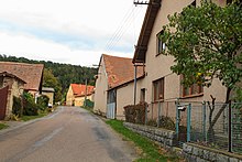
Domanice (Luže)
| Domanice | ||||
|---|---|---|---|---|
|
||||
| Basic data | ||||
| State : |
|
|||
| Region : | Pardubický kraj | |||
| District : | Chrudim | |||
| Municipality : | Luže | |||
| Geographic location : | 49 ° 54 ' N , 16 ° 3' E | |||
| Height: | 355 m nm | |||
| Residents : | 28 (2011) | |||
| Postal code : | 538 54 | |||
| License plate : | E. | |||
| traffic | ||||
| Street: | Bílý Kůň - Lozice | |||
Domanice (German Domanitz ) is a district of the city of Luže in the Czech Republic . It is located two and a half kilometers northeast of Luže and belongs to the Okres Chrudim .
geography
Domanice is located at the foot of the Poklona plateau in the Novohradská stupňovina ( Neuschlosser stepland ). The Farářství (445 m nm) rises to the south-east, the Klapalka (380 m nm) in the south.
Neighboring towns are Srbce in the north, Pešice, Svařeň and Sejtinka in the Northeast, Řepníky the east, Střemošice the southeast, Bílý Kůň , Rabouň , Doly and Janovičky in the south, Košumberk , Chlumek and Luže in the southwest, Voletice the west and Lozice , Martinice and Jenišovice in the north-west.
history
The first written mention of Domanice was in September 1415, when the owner of the fortress , Beneš Brázda, appealed to the Council of Constance on a complaint from Bohemian and Moravian lords . In 1440 Brázda was one of the participants in a gathering of East Bohemian nobles in Čáslav . The estate Domanice with the fortress, the farm and the village Domanice as well as ten other villages fell back in 1470 as a settled fief to King George of Podebrady, who left it to Jan von Bříství, Jan von Jestříbec and Heřman von Sulice. Under the Sulický family from Slepotice, the time of the small nobility and the independent estate of Domanice ended. The fortress Domanice was described as desolate in 1543 and finally disappeared without any visible traces; its location is presumed to be in the center of the village by houses no.1 and no.19. Only the Domanice farm remained as a farm for the Koschumberg lordship . After the abolition of the Jesuit order in 1773, the rule of Koschumberg fell to the religious fund .
In the course of raabization , the Domanice farm was emphyteutized in 1778 and the village consisting of ten properties was founded.
In 1835 the village of Domanitz , located in the Chrudim district , consisted of 18 houses in which 87 people, including three Protestant families, lived. There was a hunter's house away from the village. The parish was Lusche . Until the middle of the 19th century, Domanitz remained subordinate to Gut Koschumberg.
After the abolition of patrimonial Domanice formed from 1849 a district of the municipality Voletice in the judicial district Hohenmauth . From 1868 the village belonged to the political district Hohenmauth . In 1869 Domanice had 88 inhabitants and consisted of 20 houses. In 1880 the village with 105 inhabitants reached the highest population in its history. In 1900 there were 84 people in Domanice, in 1910 there were 87. In 1930 the village had 93 inhabitants. After the February revolution of 1948, the farmers of Domanice ignored the demands for collectivization for a long time; After repression by the district committee, a JZD was formed in August 1957 , which two years later was merged with the JZD Voletice. Since 1961 the village belongs to Okres Chrudim. On April 30, 1976 Domanice was incorporated into Luže together with Voletice. In the 2001 census, there were 26 people living in the 18 houses in Domanice.
Local division
The district of Domanice is part of the cadastral district of Voletice.
Attractions
- Natural monument Kusá hora, northeast of the village
- Luže Jewish Cemetery , southwest of Domanice
literature
- Historický lexikon obcí České republiky 1869–2005 , part 1, p. 512
Web links
Individual evidence
- ^ Johann Gottfried Sommer : The Kingdom of Bohemia; Represented statistically and topographically. Volume 5: Chrudimer Kreis. Prague 1837, p. 115
- ↑ http://www.uir.cz/casti-obce/184845/Domanice


