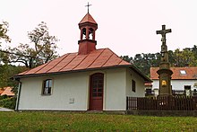
Srbce (Luže)
| Srbce | ||||
|---|---|---|---|---|
|
||||
| Basic data | ||||
| State : |
|
|||
| Region : | Pardubický kraj | |||
| District : | Chrudim | |||
| Municipality : | Luže | |||
| Area : | 251 ha | |||
| Geographic location : | 49 ° 55 ' N , 16 ° 3' E | |||
| Height: | 350 m nm | |||
| Residents : | 48 (2011) | |||
| Postal code : | 538 54 | |||
| License plate : | E. | |||
| traffic | ||||
| Street: | Bílý Kůň - Lozice | |||
Srbce (German Srbetz , 1939–45 Sorbitz ) is a district of the city of Luže in the Czech Republic . It is located three kilometers northeast of Luže and belongs to the Okres Chrudim .
geography
Srbce is located on the slope below the Poklona plateau in Novohradská stupňovina ( Neuschlosser stepland ). In the east the Kusá hora (416 m nm) rises. State road II / 305 runs west of the village between Luže and Stradouň .
Neighboring towns are Štěnec in the north, Popovec and Domoradice in the northeast, Pěšice in the east, Řepníky in the southeast, Domanice and Košumberk in the south, Luže and Voletice in the southwest, Lozice in the west and Jenišovice in the northwest.
history
Archaeological finds show that there was a fortified settlement on the spur above the village.
The first written mention of Srbce was in 1354. Between 1415 and 1450 the village belonged to the estates of the Vladiken Brázda on Domanice . After the Domanice fortress was extinguished, Srbec became subject to the Koschumberg Castle.
In 1835 the village of Srbetz , located in Chrudim County , consisted of 35 houses in which 188 people lived. There was an inn in the village. The parish was Lusche . Until the middle of the 19th century Srbetz remained subject to the Koschumberg estate.
After the abolition of patrimonial Srbce formed from 1849 a district of the municipality Voletice in the judicial district Hohenmauth . At the end of the 1850s, Srbce broke away from Voletice and formed its own municipality. From 1868 the community belonged to the political district Hohenmauth . In 1869 Srbce had 218 inhabitants and consisted of 45 houses. At that time the village was dominated by agriculture and there were no craftsmen.
In 1880 the village reached the highest population in its history with 225 inhabitants. In 1900 there were 221 people in Srbce, compared to 210 in 1910. The voluntary fire brigade was founded in 1924. In 1930 the village had 207 inhabitants.
Since 1961 the community belongs to Okres Chrudim. On April 30, 1976, Srbce was incorporated into Luže. At the 2001 census there were 64 people living in the 39 houses of Srbce.
Local division
The district of Srbce forms the cadastral district of Srbce u Luže.
Attractions
- Sandstone cross in the center of the village, created in 1821
- Chapel of Our Lady of the Rosary, built in the middle of the 19th century. Greatly enlarged in the mid-1920s with the addition of the syringe house. After 2000 the chapel was renovated; the syringe house last used as a storage room was converted into the spiritual village center and consecrated in 2002.
- Historic landmarks of the Chraustowitz rule with Koschumberg on the dirt road to Řepníky ; The granite stones set at the beginning of the 19th century are marked TT ( Thurn und Taxis ).
- Natural monument Kusá hora, east of the village
literature
- Historický lexikon obcí České republiky 1869–2005 , part 1, p. 512
Web links
Individual evidence
- ↑ http://www.uir.cz/katastralni-uzemi/752878/Srbce-u-Luze
- ^ Johann Gottfried Sommer : The Kingdom of Bohemia; Represented statistically and topographically. Volume 5: Chrudimer Kreis. Prague 1837, p. 115
- ↑ http://www.uir.cz/katastralni-uzemi/752878/Srbce-u-Luze


