
Duckbill (Glienicke)

The Entenschnabel is an area of the Brandenburg municipality of Glienicke / Nordbahn , which protrudes about 570 meters west of the Oranienburger Chaussee into Berlin . Officially referred to as "Sandkrug" in the planning of the municipality of Glienicke.
Position and shape

.jpg)
Between 1952 and 1989 the border between the Reinickendorf district and Brandenburg (then: GDR district Potsdam ) had a complicated urban and state border between the GDR and the then West Berlin district of Reinickendorf. From 1961 onwards, when the Wall was built, the situation became bizarre. The name "Entenschnabel" after the shape of the border line on a geographical map like a duck's head with a beak comes (probably primarily) from this time. This area of the community Glienicke / Nordbahn was planned in the 1930s and was named "Sandkrug".
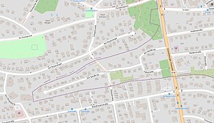
The street Am Sandkrug belongs to the municipality of Glienicke / Nordbahn. The properties addressed to her extend to the Berlin city limits: 1–23 to the north to Frohnau and 27–42 to the south to Hermsdorf . In addition, the plots 43–46 (from Falkenweg on the south side: Am Sandkrug) and 41, 43 (as Oranienburger Chaussee), as well as those on Falkenweg belong to it. The width of this recession is 120 meters at half the length. The end of the “Glienicker Sporn” is formed by Am Sandkrug 24 and 25 with a total width of 50 meters. The Oranienburger Chaussee continues the Hermsdorfer Berliner Straße . The Provincial Road led through the forest at the foot of an Ice Age inland dune , which became the eastern edge of the Frohnau settlement area to the north of the flat terrain of the Entenschnabels and from Hermsdorf . The Fürstendamm between the height at Entenschnabel and the following Zernsdorfer Höhe uses an interruption of the two ridges .
The "Am Sandkrug" cul-de-sac of the Brandenburg municipality in the Oberhavel district opens up the narrow strip that protrudes west into the Berlin area and decreases in width. It is surrounded by the streets Am Rosenanger and Am Pfingstberg , which belong to the Berlin district of Frohnau , and Burgfrauenstraße in Hermsdorf .
After the division of Berlin into the Allied sectors , the surrounding area came to West Berlin (Frohnau in the north to the western tip of the Entenschnabels, Hermsdorf in the south), and the land on both sides of the street Am Sandkrug was finally dated on three sides by the construction of the wall Berlin area separated. The location in relation to Frohnauer Strasse Am Rosenanger was remarkable. Since these houses were higher up, at the time of the division, their residents could look down over the wall to the GDR property in the street Am Sandkrug . The ascent to the north between Am Sandkrug / Silvesterweg ( 43 m ) to Am Rosenanger / Straße 114A ( 52 m ) and then to the height of the inland dune ( 67 m - behind house 75b) is 25 meters.
Streets
_1740.jpg)
.jpg)
The name “Am Sandkrug” goes back to a horse changing station “Sandkrug” in Glienicke on the Chaussee between Berlin and Oranienburg (Provinzialstraße).
“The Great Elector gave the Captain von Oranienburg the order to have a jug built in connection with a peasant farm. This is how the "Sandkrug" was created around 1670, which is also mentioned in Fontane's walks through the Mark Brandenburg region . "
The streets of Glienicke / Nordbahn are in the strip of land
- Am Sandkrug: Starting at Oranienburger Chaussee , this street runs with a bend through the area. At the west end there are two newly built housing developments on a rectangular extension of the cul-de-sac. At the time of the Wall, Plots 24, 25 were still undeveloped and there was space for wall construction. The counting of the street begins on the north side at the corner of Oranienburger Chaussee with the number 2. The consecutive horseshoe numbering changes at the western end from Am Sandkrug 24 to 25 and leads to 46 on the south side
- Oranienburger Chaussee: On the western side of the street, the house built around 1937 on the corner lot (Am Sandkrug 1) bears house number 43 (probably Oranienburger Chaussee 43). At the south corner on the corner property there was house 41 already before 1935 and according to GoogleEarth this house was still in 2015, but no longer in June 2016. This numbering collides with the counting on the maps (Oranienburger Chaussee) 9, which is due Glienicke / Nordbahn belongs. The (Brandenburg) properties on the east side in Glienicke / Nordbahn are numbered starting from the local and state border of Berlin-Hermsdorf with 1 in continuous counting up to 36 at the state border to Berlin-Frohnau.
- Falkenweg: The cul-de-sac of 100 meters, starts at the offset bend Am Sandkrug to the south, and after 30 meters turns east (as a road not through) to Oranienburger Chaussee - to which 40 meters of footpath lead.
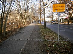
- Hasensprung: North-South connection in the Glienicker Zipfel over Am Sandkrug. The construction of the wall made this connection meaningless. Since the fall of the wall, it has been possible to cross between Hermsdorf and Frohnau through the duck's bill. The initial (plan) name was Hasensprung . This information stood for the entire street between Fürstendamm in the higher Frohnau to the lower Glienicke / Nordbahn to Hermsdorf. In Frohnau this is called north of Am Rosenanger Langohrzeile (since January 9, 1961) and to the south is road 114A with 40 meters to the state border. Within Glienicke / Nordbahn a staircase (referred to as Hasensprung on the map, but without a street sign) leads down to Am Sandkrug. The former course of the Wall is recognizable as a twelve meter long flat section.
- New Year's Eve Trail: 60 meters from Am Sandkrug, the Brandenburg (cross) section is called the New Year's Eve Trail . The road to Hermsdorf continues under the same name via Burgfrauenstrasse as the New Year's Eve through Hermsdorf . The crossing is a footpath , whereby the state border is marked with two parts of the wall in accordance with the closure that lasted until 1989.
- Lot 9: Like the “Entenschnabel”, this lot is west of the Chaussee and belongs to the municipality of Glienicke. This parcel outside of Berlin was already entered on the Silva plan from 1920. A residential building has been included as number 9 on the maps of Histomapberlin.de (since 1936). However, the Berlin maps after 1961 may not be authentic. If the former residential building in the southern area was (probably) still at the time of the Wall, it would be assumed that it would be used by the border troops. there is a 2070 m² plot of land 50 from Fürstendamm ( 52 ° 37 ′ 51.8 ″ N , 13 ° 18 ′ 36.4 ″ E ) delimited by a series of concrete piles for 65 m along the Chaussee. It is still marked by concrete posts - as they were used for the lattice fences of the border fortifications. The area is in the flat area in front of the dune slope. Whereby the border point touches the road . The property is undeveloped and overgrown with young trees, but a building ( 52 ° 37 ′ 48.5 ″ N , 13 ° 18 ′ 36.7 ″ E ) is marked on the maps under histomapberlin . On its northern edge there was a direct turn from Fürstendamm (Frohnau) to the main street in Glienicke (temporarily: Leninstraße ). This route became irrelevant (with the defined border route) since the mid-1950s and this branch was closed at the latest in 2000. The Fürstendamm crosses at the Glienicker Spitze over the Chaussee directly to Schönfließer Straße. The adjacent property is addressed with Oranienburger Chaussee 9 for Glienicke / Nordbahn. A residential building (Oranienburger Chaussee 9) is already included on the map from 1936.
- Property 9 bordered with concrete piles
North row

Opposite the south corner

Southern row of stakes
Southern tip to duckbill
Viewing from the south


history
- Situation of the area between Frohnau, Glienicke, Hermsdorf

1811: forest-free area

1913: Barnim district
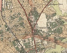
1922: Greater Berlin / Glienicke
2018: Location from OpenStreetMap
_(Entenschnabel).jpg)
_in_12_Bl%C3%A4ttern_II_Oranienburg_(Entenschnabel).jpg)
_in_12_Bl%C3%A4ttern_II_Oranienburg_(Entenschnabel).jpg)

Carrion Kute
A forest-free strip of land west of Glienicke was already recorded in 1811 and on the Schmettauschen map series (Urmes table sheet 3345, Hennigsdorf). On a historical map, north of the Hermsdorf district and west of the Chaussee, the parcel “Aaskute” is shown free of forest and settlement.
Kissling's large special map from 1911 shows a forest-free strip of land of around 500 m × 100 m, which borders directly on Hermsdorf in the south. This area is bordered by forest on three sides. From the north, a road is drawn through the parcel to the Hermsdorf district. It continues the Hasensprung street that comes from Fürstendamm / Fischtalweg and crosses Am Rosenanger. Along the Chaussee there is a wooded strip about 30 meters wide with buildings belonging to the Glienicke district.
The Berlin Terrain-Centrale bought - promoted by the Berliner Nordbahn - from the von Veltheim family in Schönfließ a forest area north of Hermsdorf, at that time a municipality in the Barnim district . On December 10, 1907 Werner von Veltheim sold around 750 hectares of land in the Stolper Heide area . The heather area bordered along the dune slope, which explains the whereabouts of the terrain spur between heather and Hermsdorf near the municipality of Glienicke. On May 7, 1910, the inauguration of the garden city Frohnau, initiated by the Upper Silesian Prince Guido Henckel von Donnersmarck , was celebrated. The planned land belonged to the Stolpe district. At the same time, planning was carried out in Glienicke and the subsequent development and settlement of Glienicke-West. On the Silva map from 1920, the Glienicker Zipfel is a piece of forest between Frohnau Am Rosenanger and Hermsdorfer Planstrasse 64 (= Burgfrauenstrasse), with an "unpaved road" connecting Frohnau and Hermsdorf through a piece of forest. The narrow parcel outside Berlin was already entered on the Silva plan from 1920.
Sand jar
In the 1930s, the planning of the "Sandkrug" pinnacle and the first developments took place. Until the 1950s it was insignificant that the strip of land belonged to the Glienicker Flur.
The historic route of the federal highway 96 from Hermsdorf crossed Glienicke past the Geländesporn and lay in a northerly direction at about 1100 meters on the Berlin outskirts, of which more than 800 meters only exactly around the street width, before it again led through Berlin-Frohnau. Because this section ran directly on the border, it was no longer usable as a civil road for the GDR with the border with West Berlin. The through traffic had to be diverted via Herrmann- / Hattwichstraße, which turned all other streets into cul-de-sac . Due to border measures from June 1, 1952, it was no longer possible for Berliners to pass through the duck's bill. In West Berlin, traffic on Berliner Strasse had to be diverted to Burgfrauenstrasse and Zeltinger Strasse to Oranienburger Chaussee for almost 38 years. The Bieselheide with the Oranienburger Chaussee in turn belonged to the district Frohnau, which - like the Stolper Heide - extends in the north to the east. The (historical) Chaussee then moved again from the Berlin district of Reinickendorf to the GDR district of Potsdam.
Wall time 1961–1989
On August 13, 1961, the cordon was finally closed. The delimited area at the duck's bill prevented the border strip typical of Berlin from being executed here with the security systems. These had not found a place or there would have been no usable space. This was only about three meters wide. At the end of the dead end a larger open space was created later. The wall soon replaced the wire barriers and was initially made of pushed together transverse concrete slabs. The border security consisted of the actual wall and the hinterland fence . It was covered by vegetation, at least from the Berlin side. Around 1980 the previous system was replaced by new, large precast concrete parts on top with roller elements and these were painted white. The four meter wide unobstructed death strip was delimited on the Glienicker property by a metal mesh fence. These edgewise elements had the support leg on the outside to make it difficult to press from the GDR side. The “weak” situation caused by the narrow security strip meant that “reliable” GDR citizens (probably not just SED members) remained. All visitors, whether craftsmen or doctors, required a special permit. Occasionally the residents could not leave their homes, they had to comply with the special rules for border areas. This location was also convenient for the Ministry of State Security , which, among other things, has been building radio technology for Department III here since the late 1970s , for which vacant residential buildings were used.

Before the fall of the Berlin Wall , there were repeated initiatives by the West Berlin Senate since the mid-1960s to bring about a border straightening. This was not possible when the territory was exchanged in 1987. A solution failed, among other things because of the formal justification that the area around the duckbill was inhabited. At the time, however, the GDR negotiators had signaled to the West Berlin Senate that further corrections might be possible in the mid-1990s. For example, the exchange of the duck's bill with Albrechts Teerofen was under discussion. With the fall of the Berlin Wall after the political change , these considerations lost their foundation.
The “Entenschnabel” passage for the F 96 / B 96 was opened on March 3, 1990. A Berlin border crossing was created for Oranienburger Chaussee at the change of location between Glienicke / Nordbahn and Hermsdorf (Berliner Straße). Together with the northern border crossing already created on February 17, 1990 from Hohen Neuendorf to Oranienburger Chaussee (Frohnau), the F 96 / B 96 was passable again. Border crossings also lost their importance on October 3, 1990 with German reunification .
Escape tunnel in Glienicke
The peculiarities of the location of land not belonging to Berlin on the GDR side offered excellent conditions for undermining the border area. In addition, as an ice age relic , sand made digging in the ground easier . The border fortification in the tip was only a few meters wide, because this facility could only be built on the GDR (inner) side. In 1962/1963, the three von Glienicke citizens dug their way to West Berlin. The three escape tunnels , however, were not driven out of the strip of land around the duck's bill. At risk of death and in front of the border guards, more than 50 people managed to escape to the West.
The Beckertunnel was built under the Oranienburger Chaussee. The Beckers' property was at Oranienburger Chaussee 13 and the family was faced with a forced relocation on February 1, 1962. So the decision was made to go under the street and reach the opposite side of the Frohnau. After three days were needed to remove the basement wall, digging through the sand followed. The movement of the sand was not allowed to be visible from the outside. The Beckertunnel was 30 meters long, it was 1.20 meters wide and 60 centimeters high. After the last excavation, the escape took place on January 24, 1962. In addition to the family members, 14 people were unexpectedly present, a total of 28 people who were greeted by police across the street. The Beckers would have been relocated in the following days. The tunnel was betrayed and three hours after the last one escaped, the Stasi discovered it. Just a few days after the successful escape under the death strip, pioneers tore down the house of the Becker family. The story of the Becker Tunnel was freely recreated as the film Tunnel 28 .
The Thomas Tunnel followed second . The Thomas family and Max Thomas owned the property at Oranienburger Chaussee 22. The family was separated when the Wall was built on August 13, 1961. They found out about the Beckers' tunnel and wanted to be part of this escape. Too much concrete was found during test drillings from the living room. The Thomas family began digging out of the hen house on April 19, 1962. “The tunnel was braced and supported with wood. The wood for the stamps in the tunnel was sawn to size in the house. ”The sand was brought to the horse stable and stored unseen. The excavation was carried out day and night and the tunnel with a height of 1.75 meters reached a length of 32 meters. The escape began with the breakthrough on the evening of May 5, 1962, the tunnel exit was still on the territory of the GDR and the exit on the embankment was small. The twelve refugees were helped by the French and the police. The tunnel was only reported after two days. Because of the older people, in particular Max Thomas was 81 years old, there was publicity about the pensioner tunnel .
The third excavation was the Aagaard tunnel . The Aagard family lived at Glienicker Ottostraße 7 and directly at the garden fence was Veltheimstraße in Hermsdorf, the properties of which were lower. The Aagaards, like their neighbors, were afraid of being resettled from the border area. With the beginning of the permanent construction of the wall, the plan was created in the summer of 1962 and the excavation began on October 5, 1962, the excavation began directly under the patio door from the living room. It was dug in the day. At night, a total of 25 m³ of sand - as there was no cellar - was hidden in the spaces between the house. The breakthrough to Veltheimstrasse took place on March 8, 1963. Mainly with the hands, 50 meters of tunnel were dug in five months. The escape took place from March 9-10, 1963 by 13 people. At first they stayed in the tunnel one after the other until Martin Willner had fetched police officers to prevent the border police from using firearms. The escape ended unharmed at four in the morning. The GDR authorities became aware of the tunnel because the hairdressing salon did not open the following day.
The residential building at Ottostraße 7 was preserved and in the 2010s the former resident found remnants of his sand storage in the false ceilings. During archaeological excavations in 2011, remains of the Aagard tunnel were found. The two houses on Oranienburger Chaussee were demolished and the border fortifications built over them. Lot 13 was 100 meters and number 22 was 300 meters north of the Fürstendamm / Schönfließer Straße intersection. The buildings were removed for the wall to be built in the early 1960s. After the fall and demolition of the wall, the municipality of Glienicke / Nordbahn built the “Glienicker Spitze”, a residential and commercial area and shopping center between Oranienburger Chaussee and Schönfließer Straße. On the western side of the Chaussee there is a footpath that leads from Fürstendamm over the foothills of the dune to the Frohnauer houses (Oranienburger Chaussee 13, 14 and following). After 60 years and the border regime, traces of these tunnels can no longer be found.
Current situation
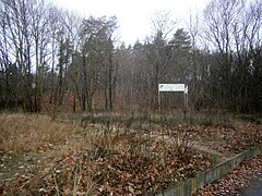
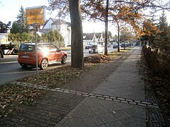
There is hardly any visible evidence of the course of the wall. The former border fortification to West Berlin was removed, the last parts of the wall at the duck's bill fell in February 1991. Privatized areas were released for building. During excavations in the 2010s, the foundations of watchtowers, parts of the barbed wire barriers, signal systems, ammunition and remains of the tunnels were found. In the 1990s the road was rebuilt. At the location of the Becker tunnel, nothing reminds of the border; just as little further north, where the 81-year-old Max Thomas fled with relatives through the "pensioner tunnel" in May 1962. The historic route of the federal highway 96 was already open again in 1990. Only the place-name signs now show the change to the federal state of Brandenburg, before driving through Berlin again after around one kilometer. There is a memorial stele and plaques for the Berlin Wall Trail on Bundesstraße 96, next to the entrance to the Am Sandkrug street . Glienicker Straße Am Sandkrug is still a dead end. The duck's bill between the federal states of Brandenburg and Berlin belongs to the Oberhavel district and the police license plate valid here is OHV . Via the stairs from Frohnau - and on two parts of the wall via the Silvesterweg - Hermsdorf can be reached. The cross-connection has existed again since 2016. New buildings were built on Oranienburger Chaussee and with the establishment of a business center "Glienicker Spitze", residents lost their memories of the Wall and the death strip. In the area under consideration between Frohnau and Glienicke, three escapes with fatalities failed.
The Berlin Wall Trail runs along Oranienburger Chaussee . It is located from the north on its west side and on the footpath that once led along in front of the wall. A side route of the Wall Trail leads to the "Enclave Entenschnabel (1961–1989)" at the street Am Sandkrug. South of the duckbill, the Wall Trail leads east along Veltheimstrasse on the Zollweg in Berlin. In addition, the red-marked hiking trail advertised by the Reinickendorf district - leading along the Frohnau inland dunes - leads past the duck's bill. Coming from Frohnauer Fürstendamm between Berlin and Brandenburg on Oranienburger Chaussee , the Deutsche Tonstrasse is parallel to the Wall Trail for a kilometer. The memorial and two information boards about the Aagard tunnel are located in Glienicke / Nordbahn and can be reached via Niederstraße.

Straße Am Sandkrug

Memorial plaques on the B 96
State border of Berlin (paving strips: formerly the course of the Wall)
... and a look at the strip of Glienicke

Note: Berlin Wall Trail


literature
- Florina Limberg, Sebastian Teutsch :: Entenschnabel - About living with the wall as a garden fence. Heimatmuseum Reinickendorf (ed.), 3rd verb. Edition, Berlin 2015, ISBN 978-3-931658-00-7 .
Web links
- Map section
- Photo of the duck's bill ("Schnabelspitze")
- Entenschnabel - About living with the wall as a garden fence. Info page for the publication of the same name at kirschendieb-perlensucher.de
- Wall memorial and memorial on Silvesterweg between Glienicke Nordbahn and Berlin-Hermsdorf, erected in 2013; Photo taken in 2015. In: Chronicle of the Wall
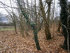
- Row of posts of a hinterland fence in the "Entenschnabel" between Berlin-Hermsdorf and Glienicke Nordbahn; Photo taken in 2015. In: Chronicle of the Wall
- Images: Glienicke / Nordbahn and “Entenschnabel”. At: Chronicle of the Wall
- Expanded metal mesh fence as a garden fence in the "Entenschnabel" between Berlin-Hermsdorf and Glienicke Nordbahn; Photo taken in 2015. In: Chronicle of the Wall
- The "Senioren-Tunnel": Successful tunnel escape from Glienicke / Nordbahn to Berlin-Frohnau, May 5, 1962. In: Chronicle of the Wall
- Chronicle 1961. At chronik-der-mauer.de
- Row of posts of a barrier fence on Oranienburger Strasse between Berlin-Hermsdorf and Glienicke Nordbahn (1); Recording 2015. At chronik-der-mauer.de
- Successful escape from Glienicke / Nordbahn to Berlin-Reinickendorf with the help of a ladder, January 20, 1986 in: Chronicle of the Wall
- Failed escape with a truck in Glienicke / Nordbahn, April 26, 1989. In: Chronicle of the Wall
- 25-years-fall-of-the-berlin-wall on https://ipeters.wordpress.com/2014/10/23/
- footage-berlin.com : Video with a view from the west over the modernized Berlin Wall shows a street completely enclosed by the wall - the shape is reminiscent of a duck's bill.
Individual evidence
- ↑ Welcome to the website of the Glienicke / Nordbahn community!
- ↑ green: streets of Berlin, yellow: Chaussee, blue: streets in Glienicke, black: national border, turquoise: streets in the duck's bill
- ^ Map of Berlin 1: 5000 (K5 - color edition): Am Sandkrug between Hermsdorf and Frohnau
- ↑ histomapberlin.de map 4446 / 444B from the years 1936, 1938, 1944, 1951, 1962, 1966, 1980, 1988 and 1994, search keyword 'Burgfrauenstrasse' or 'Fischgrund'
- ^ Map of the municipality of Glienicke / Nordbahn in the Oberhavel district of Brandenburg
- ↑ On the official map series "City Map of Berlin" on a scale of 1: 4,000, map "4446 1938", the following properties on Entenschnabel are already built on: Oranienburger Chaussee (west side) 41, 43, Am Steinberg 2/3, 4/5, 10, 11, 15, 27, 29a, 33, 37, (39), 40, Falkenweg 2, 3, 11, (12). The (paved) (access) road is only marked from the Silvesterweg to the right in Am Steinkrug; accordingly only the plots 10, 11; 39, 40 numbered. Another house building can be seen on the map in 1951 compared to 1944 (Am Steinkrug 17–23). The semi-detached house 4/5, however, has been omitted.
- ↑ Niederstraße was added to Chaussee (B 96) in 1896, and Leipziger Straße followed in 1911.
- ↑ Such overgrown dunes can be found in several places in Berlin's glacial valley, which arose as a result of the thawing ice masses of the Vistula glaciation . The flat, sandy valley floor provided the material from which the wind blew sand dune mountains at the end of the last ice age.
- ↑ compare the increase on Fürstendamm .
- ↑ Elevation of the terrain along the Oranienburger Chaussee on both sides of the Fürstendamm.
- ↑ a b The pictures on the website Station 03 - Entenschnabel on chronik-der-mauer.de give an impression of the location of the wall on the northern edge of the Entenschnabel
- ↑ Elevation of the terrain between Am Rosenanger and Burgfrauenstrasse
- ↑ Elevation of the terrain (Environmental Atlas): Am Sandkrug * Am Rosenanger
- ↑ The horse changing station "Sandkrug" in Glienicke on an etching from 1740. In the background the first village church .
- ↑ View from Am Pfingstberg (34) of the wall and the duck's bill, houses 24 and 25 are missing
- ↑ The continuous count from Frohnau ends from the north on the east side of the street at the state border (northeast corner of Leipziger Strasse) with 68a, on the west side the Frohnau development begins with house number 10 northwards.
- ↑ Silva overview plan of the city of Berlin and its 20 administrative districts based on the law of April 27, 1920
- ↑ Compare also the aerial photo from 1953 on GoogleEarth: between Fürstendamm / Hauptstraße and Am Sandkrug (52 ° 37'47 N, 13 ° 18'32 E ) a piece of forest can be seen (before the wall was built).
-
↑ The property is bounded by:
- Northwest corner: 52 ° 37 ′ 50.1 ″ N , 13 ° 18 ′ 35.1 ″ E
- Northeast corner: 52 ° 37 ′ 50.1 ″ N , 13 ° 18 ′ 36.6 ″ E
- Southwest corner: 52 ° 37 ′ 48.2 ″ N , 13 ° 18 ′ 34.9 ″ E
- Southeast corner: 52 ° 37 ′ 47.9 ″ N , 13 ° 18 ′ 36.9 ″ E
- ↑ Elevation of terrain: Glienicke / Nordbahn, Oranienburger Chaussee 9
- ↑ The square of plot 9 is located on the south corner of main street number 8 as a corner plot of main street 1/2. The built-up property 10/11, "Green House", is located diagonally between Hauptstrasse and Schönfließer Strasse.
- ↑ The forest-free area extends in the Stolp'schen Heide from the Chaussee am Sandkrug south of the Glienicke town center to the connecting path between Hermsdorf and Stolpe. In the middle of the map section, the Sandkrug is indicated below Glienicker Dorfstraße. There is a local connection from Hennigsdorf-Neubrück through the Stolpsche Heide (for example on the Fürstendamm train) over the Chaussee to Glienicke. From the connection to the Chaussee, the path leads northeast to Schönfließ and through Glienicke to Schilde (= Schildow). On a third of the way between Glienicke and Hermsdorf / Tegeler Fließ, the forest-free strip is opposite the "Sandkrug Chausseestation" (Niederbarnimscher Kreis).
- ↑ Topographical survey of the federal states of Brandenburg and Berlin from 1825 onwards. The production of the Prussian original table sheets began in 1822 for the entire territory of Prussia.
- ↑ Historical maps of the Glienicke district: Historical map 03 (PDF) . The exact date of the cards is not noted. Niederstraße was added to Provinzialstraße (today's B 96) in 1896, Leipziger Straße in 1911. The name 'Aaskute' probably goes back to the fact that animal carcasses were left there for the ravens. The proximity to the relaxation area of the sand pitcher (with the occasional horse corpses) may have played a role. The area was planned in the 1930s and was already named Sandkrug.
- ↑ Duden.de : die Kute, North German, especially Berlin = deepening; pit
- ^ Hans Brendicke, Paul Adam: Berlin vocabulary at the time of Kaiser Wilhelm I. Verlag des Verein für die Geschichte Berlins, Berlin 1897, online in the Google book search: "Aaskute, die, die Schindergrube".
- ↑ This tub was opposite Niederstrasse and Bismarckstrasse (= Koebisstrasse), west of the Chaussee between the Hermsdorf district and the parcel 3/96 (2050 m²), which is shown with two buildings. The latter was below the inland dune. In the Aaskute, the “Schindacker”, the cattle that had “fallen over” (after epidemics and diseases) were skinned and buried by the skinner . Correspondingly, the smell of carrion spread and places far away from the places were chosen.
- ↑ digital.zlb.de : This object cite “Kiessling's large special map of the area around Berlin Berliner Grossstadtgeschichten”, accessed December 27, 2018, http://grossstadtgeschichten-berlin.de/items/show/489 .
- ↑ There is no more detailed information on the type of forest on the map, but the shade of green stands for it.
- ↑ At this point on the map, the course of Am Rosenanger continues as Zernsdorfer Weg. There are two built-up plots on Hasensprung near Im Fischgrund (at that time Fischtalweg: Scholzsches and Wolffsches Haus). The Fürstendamm does not (yet) lead to the Chaussee. The two buildings on the Chaussee - with another in the background - are opposite the corridor between Niederstrasse and Koebisstrasse (at that time Bismarckstrasse ), corresponding to numbers 41 and 43. Another development on the western side of the Chaussee is opposite the Glienicker Hauptstrasse. (Plot 9)
- ↑ The Stolper Heide was a forest belonging to the von Veltheim family between Hennigsdorf and Schönfließ.
- ↑ Compare also: overview plan of the administrative district Reinickendorf . In: Berliner Adreßbuch , 1922, IV. Part, p. 1837. "# 1922: p. 6812 /: Am Rosenanger is registered as a cross street to Fürstendamm and is undeveloped" (The street Hasensprung leads continuously over the wooded area: It is in Frohnau between Fürstendamm and Rosenanger recorded and recorded by name for Hermsdorf undeveloped (plan: Straße 66 ) from Bismarckstraße (= Hermsdorfer Damm).).
- ↑ Silva overview plan of the city of Berlin and its 20 administrative districts based on the law of April 27, 1920
- ↑ Frohnau and Hermsdorf . In: Berliner Adreßbuch , 1943, IV., P. 2488. "Frohnau: Am Rosenanger from Im Fischgrund to Feldmark: right side: 2–10 ← Am Biberbau (Burgfrauenstrasse – Am Rosenanger) → 12–24 ← Am Pfingstberg (Hermsdorf) (1–28) –Am Rosenanger → 26–58 ← Hasengrund (Fürstendamm – Im Fischgrund – Am Rosenanger) → 60–80, Feldmark // Hermsdorf: Burgfrauenstrasse from Frohnau (1–51 and 2–58) to Berliner Strasse (no . 130 and 131): left side: ← Frohnau district → 53–83 ← Am Pfingstberg → 85–113 ← Silvesterweg (right:… ← Burgfrauenstrasse → 74–78 / left: 75 – construction sites ← Glienicke district →) → 115–125 ← Roedernstrasse (/) → 127–131 “.
- ↑ Blocking of the B 96 at Entenschnabel
- ↑ Some houses stood with the wall directly or very close to the metal mesh fence. At the western end there was a free 60 m long and 50 m wide “shooting area” between the inner metal mesh fence and the concrete wall. Before the renovation, there was a continuation of the four-meter strip, in front of which there was obviously Glienicker corridor outside the wall. The systems were clearly visible from the higher-lying residential building at Am Pfingstberg 30/32, which was built in the 1970s. According to the pictures: Aerial photo of Entenschnabel 1976, picture in the state archive / Karl-Heinz Schubert , Entenschnabel: The enclave of Glienicke, Potsdam / GDR district protrudes into West Berlin (northeast). Photo archive Hendrik G. Pastor Entenschnabel - About life with the wall as a garden fence - cherry thief & pearl seeker cultural projects , 20 years since the fall of the wall: the view from above was also forbidden , Terrassenhaus, Am Pfingstberg, Frohnau, photographer Gerfalke on 11 July 2011
- ↑ Andreas Conrad: A bike tour along the old border . In: Der Tagesspiegel , February 5, 2018
- ↑ Soil types 2010: between Am Rosenanger and Burgfrauenstrasse , legend: each upper and lower soil: fine sand (without silt light magenta) and more towards the southeast (orange) fine sand, medium sand, medium-loamy sand
- ↑ The plot widths are 20 meters and the plot depths in the east of the duck's bill are closer to 50 meters and decreasing to 30 meters to the west.
- ↑ a b The Beckers boldly undermined the death strip . In: Die Welt , October 25, 2015
- ↑ a b RBB: Vanishing point duckbill from the series Mysterious Places
- ^ The RBB television documentary vanishing point "Entenschnabel" - The tunnel builders from Glienicke / Nordbahn .
- ↑ The Becker Tunnel : "In January 1962, the Glienicke twins Bruno and Günther Becker dig one of the first tunnels on Oranienburger Chaussee."
- ↑ a b The picture at station 02 on chronik-der-mauer.de gives an impression of what the Oranienburger Chaussee with the Berlin Wall and full border system looked like.
- ↑ The Thomas Tunnel : "Only about a hundred meters from the Beckers' first escape point, another spectacular tunnel escape by the Thomas Glienicke family in May 1962."
- ↑ www.fluchttunnel-glienicke.de : “There was an agreed secret number that had to be given on the phone. However, they fled together with Werner on January 24, 1962 without calling Herbert and Dora. Didn't take us, said in German. "
- ↑ fluchttunnel-glienicke.de : “The nurse who had lived with Thomas noticed the absence of the Thomas family two days after their escape. She went to the mayor and filed a complaint. The Stasi let her go: They said that otherwise she could have left with us. "
- ↑ The Aagaard tunnel : "The spiral of harassment only ends with the renewed escape of 13 people through the Aagaard tunnel in Ottostraße in March 1963."
- ↑ The Aagaard tunnel : “In 1961 the Aagaard family, Niels-Martin and Lucie lived with their son Detlef and grandmother Gertrud (70) at Ottostraße 7 in Glienicke. Lucie Aagaard ran a hairdressing salon, Niels-Martin was a worker. The border to Veltheimstrasse in Hermsdorf (West Berlin) was right at the garden fence. The border strip was only about 40 meters wide here. "
- ↑ The Aagaard Tunnel
- ↑ Archeology : In Ottostraße, the archaeologists first uncovered the remains of a watchtower and a residential building that had been demolished during the construction of the wall. They later succeeded in uncovering part of the Aagaard tunnel, which is located on vacant private property.
- ↑ Glienicke escape tunnel: pictures of the excavation and selected finds
- ↑ Section of the Wall Trail Hohen Neuendorf – Hermsdorf ( Memento of the original from March 14, 2016 in the Internet Archive ) Info: The archive link was automatically inserted and not yet checked. Please check the original and archive link according to the instructions and then remove this notice.
- ↑ The memorial stele and the commemorative plaques are located at the confluence of Am Sandkrug on Oranienburger Chaussee - the B 96 - the wall train itself stood south across the street. And on the other hand to the north and on Fürstendamm on the west side of the Chaussee.
Coordinates: 52 ° 37 ′ 40 ″ N , 13 ° 18 ′ 20 ″ E