
Feteşti
| Feteşti | |||||
|
|||||
| Basic data | |||||
|---|---|---|---|---|---|
| State : |
|
||||
| Historical region : | Great Wallachia | ||||
| Circle : | Ialomița | ||||
| Coordinates : | 44 ° 23 ' N , 27 ° 50' E | ||||
| Time zone : | EET ( UTC +2) | ||||
| Height : | 20 m | ||||
| Area : | 101.22 km² | ||||
| Residents : | 30,217 (October 20, 2011) | ||||
| Population density : | 299 inhabitants per km² | ||||
| Postal code : | 925100 | ||||
| Telephone code : | (+40) 02 43 | ||||
| License plate : | IL | ||||
| Structure and administration (as of 2016) | |||||
| Community type : | Municipality | ||||
| Structure : | 3 districts / cadastral communities: Buliga , Feteşti-Gară , Vlaşca | ||||
| Mayor : | Sorin Gafițoi ( PSD ) | ||||
| Postal address : | Călărași street, no. 554 loc. Feteşti, jud. Ialomița, RO-925100 |
||||
| Website : | |||||


Feteşti is a city in Ialomița County , in the Wallachian Plain , in Romania .
Geographical location

The city of Feteşti is located in the southern part of the Bărăgan - the so-called Bărăganul Ialomiței - on the left bank of the Brațul Borcea , a tributary of the Danube . Located in the southeast of the Ialomița district, the city is connected to the Romanian A2 motorway between Bucharest and Constanța and is therefore 61 kilometers away from the district capital Slobozia .
history
The place, formerly a Romanian Hörigendorf , was first mentioned in 1528 by Prince Radu de la Afumați as a market town . In 1868 it was made a community and (according to different statements) in 1934 or 1965 a city. 1995 Feteşti receives the status of a municipality ( Municipiu ).
The name of the place derives - according to the legend - from " satul cu fete " ("the village with the girls") with the reason: "The shepherds of Bărăgan came to this place to find their future wife".
population
In 2002, 33,294 or 34,594 inhabitants were registered in the city (according to different data); on January 1, 2009 - according to the 2002 census - approx. 3% more people were counted in the area of the municipality.
traffic
In addition to the Romanian A2 motorway, Feteşti is on the National Road Drum național 3B , a road connecting the city of Călăraşi ( Kr.Călăraşi ) - southwest of Feteşti - with the European route 60 (51 km), north of Feteşti. The city is also a railway junction on the Bucureşti – Constanța – Mangalia and Buzău – Feteşti railway lines . There is an airfield that the Romanian Air Force uses as Air Base 86 .
Attractions
- The Anghel-Saligny Bridge - also called King Carol I Bridge - was built by the architect Anghel Saligny for the railway line from Feteşti to Cernavodă across the Danube and its Borcea arm . The 4087.95 meter long truss bridge was built for five years until it was inaugurated by King Carl I on November 26, 1890 .
- The Balta Ialomiței is a swampy island on the lower reaches of the Danube between this and the Borcea arm.

The Anghel Saligny Bridge, by Raymund Netzhammer (1909)
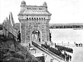
The Anghel Saligny Bridge with the inscription Podul Regele Carol I

The Anghel Saligny Bridge

View of the old and new railway bridges

Flooding in the Balta Ialomiţei


Personalities
Born in Feteşti:
- Ion Mihăilescu (born 1916), football player
- Ion Vlad (1920–1992), sculptor, emigrated to Paris from Romania since 1965.
See also
Web links
Individual evidence
- ↑ 2011 census in Romania at citypopulation.de
- ↑ a b Strategia de Dezvoltare a Municipiului Feteşti 2010–2020 (PDF; 8.0 MB) “Strategic Development Feteştis, 2010–2020” (July 28, 2010), accessed on August 9, 2010 (Romanian)
- ↑ a b History of the place on the website of the Municipality of Feteşti, accessed on August 9, 2010 (Romanian)
- ↑ 2002 census
- ↑ http://www.cfr.ro/CFR_new/Eng/poduri.htm ( Memento from April 2, 2012 in the Internet Archive ) (English)
- ↑ Ion Vlad, at www.romaniaculturala.ro ( Memento from September 24, 2015 in the Internet Archive ) (Romanian)