
Funtana Chistagna
| Funtana Chistagna
|
||
|---|---|---|
| Location: | Canton of Graubünden , Switzerland | |
| Height : | 1815 m above sea level M. | |
|
Geographic location: |
827 906 / 189 087 | |
|
||
| Cadastral number: | 30th | |
| Overall length: | 290 m | |
| Particularities: | Not developed for tourism. Quellbach intermittently until the beginning of the 19th century. | |

The Funtana Chistagna (pronunciation [ funˌtanːɐ tɕiˈʃtaɲɐ ], simplified funt a nna tschish a nja ) is a karst spring and vadose stalactite cave in the Val d'Assa in the Swiss Lower Engadine .
Written sources indicate that the intermittent source has been known since at least 1562. At that time and up to the 18th or even 19th century , the spring dried up several times a day, according to various sources. Since then, only small, weather-dependent fluctuations in the discharge have been recorded.
The cave has a measured length of 290 meters, with a vertical extension of almost 39 meters. It is not developed for tourism.
Surname
The name of the source has undergone various orthographic adaptations over the years. The following terms were and are used in chronological order: "Fontana Chistaina" , "Funtana Sistaina" , "Fontana Chi staina" , "Funtana Chistaina" , "Funtana chi staina" and "Funtana Chistagna" . "Funtana Chistagna" is the official name today.
The name originated from the sentence fragment "funtana chi stagna" which in the local idiom Vallader "source runs dry" means (lat. Stagnare jam ). An earlier interpretation of the name as fontana quae se tenet (Latin for "source that holds" or "source that pauses" ) has been rejected.
While in German terms and names are usually formed with the help of compound words as well as adjectives or participles (here hypothetical examples would be “Feenquelle” , “Steinerne Träne” , “Stallende Quelle” ), in Romansh it is not uncommon to use short relative clauses . The initially strange name formation “funtana chi stagna” corresponds to numerous other Rhaeto-Romanic terms of the type “staila chi crouda” (German “star that falls” = “shooting star” ).
Partial translations of the type "Quelle Chistagna" or "Chistagna Fountain" are not common in German or English literature.
Location and accessibility
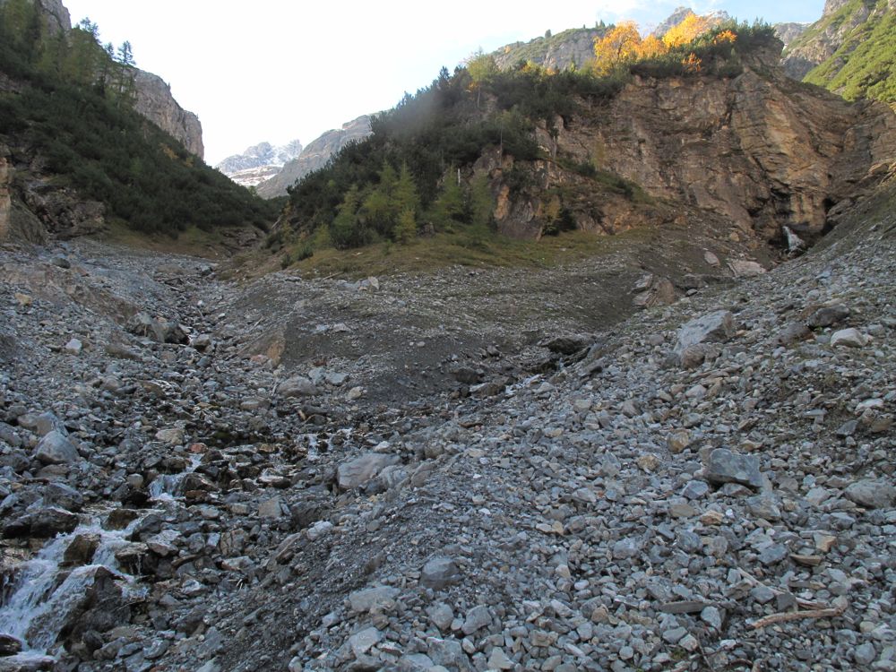
The source is located at 1815 m above sea level. M. in the Val d'Assa (literally "Bretttal" ), a short side valley of the Swiss Lower Engadine, on the flank of Piz S-chalambert Dadaint ( 3,031 m above sea level ). The area belongs to the place Ramosch and thus politically to the municipality of Valsot .
The source can be reached in a two to three-hour hike from the “Strada Seraplana” stop of the Swiss Post .
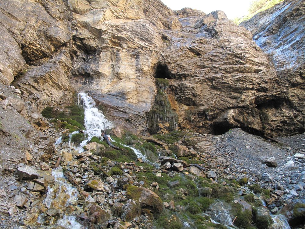
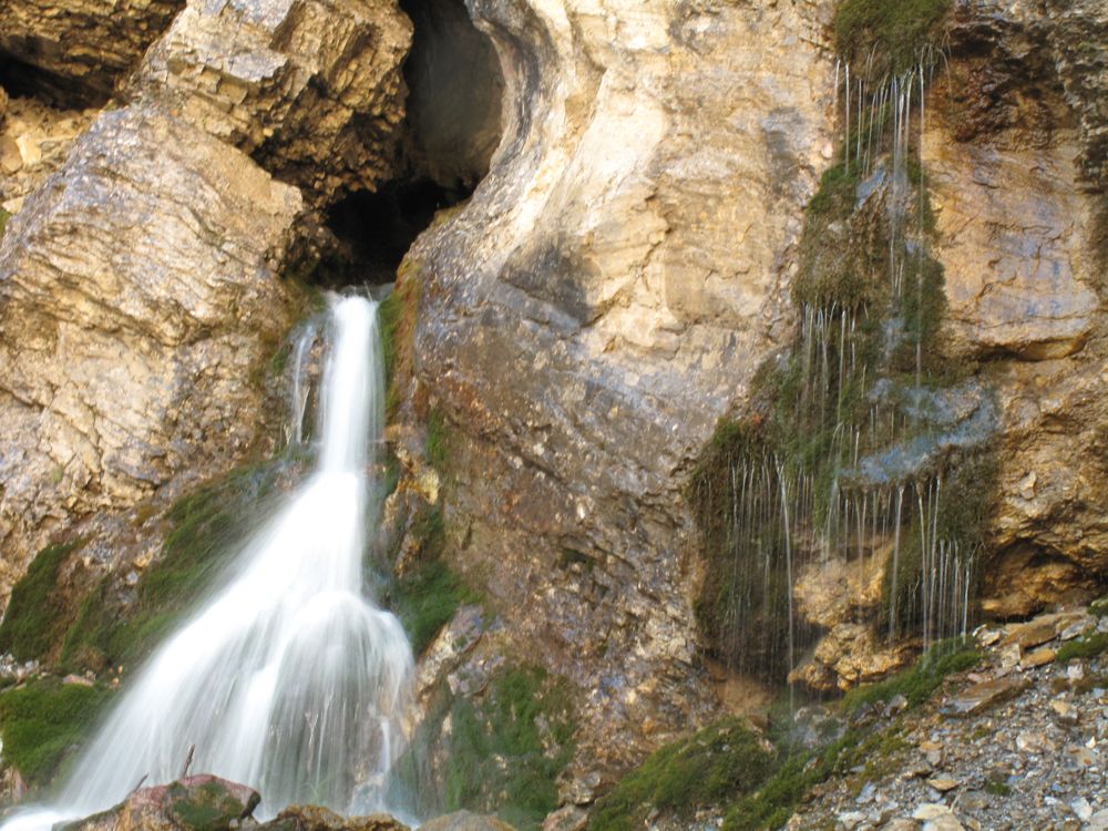
At the location of the source there are four cave entrances in a rock wall. The spring water flows out of one of the caves in the form of a small waterfall, while the other caves are dry.
The caves can be reached by easy climbing. In the 1950s there was an inspection aid in the form of piles set into the ground in the entrance area of the active cave.
The spring water flows off as Aua da Val d'Assa and would naturally flow into the Inn at Ramosch Resgia . The Aua da Val d'Assa , however, is captured beforehand and fed to the hydropower plant in Martina .
Research and publication history
As far as we know today, the source has been known since the 16th century. The following events led to the exploration of the cave as well as to the tourist announcement:
- 1562: The Engadin reformer and Bible translator Duri Champell examines the source. He notes three cycles a day. According to his information, the pouring began at 9 a.m., at 12 p.m. and in the evening.
- 1563/1565: The natural scientist Conrad Gessner from Zurich reports a little later on cycles that consist of a two-hour pouring followed by a two-hour break, which would result in six cycles per day.
- 1770: The Appenzell geographer Gabriel Walser describes the source in his Schweitzer geography, including the peculiarities in the Alps and high mountains .
- 1788: The local pastor, educator and researcher Peider Nuot Saluz from Lavin also notices a pulsation, but comes to different cycle lengths than Duri Champell and Conrad Gesner.
- 1810: The travel journalist Johann Gottfried Ebel describes the morphology of the then known, 50 meter long cave in a travel guide.
- 1857: The doctor Jacob Papon , a nature-loving spa guest in nearby Vulpera and member of the board of the Natural Research Society of Graubünden, can no longer observe cycles in which the spring has completely dried up.
- 1866: On August 17, 1866, the doctor and natural scientist Eduard Killias from nearby Scuol also found that the source was no longer pulsing, or at least not at all.
- 1884: Eduard Killias writes a six-page description of the source in the Swiss Alpine newspaper .
- 1895: The source is mentioned for tourists in the guide Der Tourist in der Schweiz by Iwan von Tschudi .
- 1909: The geologist Christian Tarnuzzer from Chur examines springs and caves.
- 1924: Water flow, water temperature and air temperature are scientifically researched from August 8th to 15th. The absence of a regular, complete pulsation is confirmed once more. Instead, a connection with the precipitation and the temperature-related meltwater flow is established.
- 1935: The cave is recorded in the cadastre of the Swiss caves , but not to the extent of the information about the cave already known at the time.
- 1953: Up to this point only the first 50 m of the spring cave are known.
- 1953: On August 15, the Englishman John Hooper , his wife Winifred Hooper (aka "Win Hooper" or "The Weasel" , literally "The Wiesel" ) and the Zurich Theodor F. Anker examine the cave. Your primary interest is not caving , but zoology : You are looking for bats to hibernate . Thanks lucky coincidences they succeed in the later than weasel hole designated silt to open and thus the familiar horizon of 50 m to increase m on 250th
- 1954: In August, the Hooper and Theodor Anker couple expand on the previous year's discoveries. In the two following years, Theodor F. Anker explored the cave with members of the Swiss Society for Speleology and created a cave map of the main passage on a scale of 1: 500.
- 1956: John Hooper publishes the results of the latest discovery in the Bulletin of the National Speleological Society .
- 1974: During several expeditions, Jörg and Max Steiner of the Eastern Switzerland Society for Cave Research (OGH) explore the cave system. A detailed cave plan on a scale of 1: 200 was created. The cave explorers also took temperature measurements of the air and water as well as investigations of the sediments , flora and fauna .
- 1980s: There are diving advances by cave divers in the cave.
Intermittency
The spring has been described as one of the few intermittent springs in Switzerland since Duri Champell . According to the authors, by 1788 the spring ran dry several times a day. By then, the authors reported two to six cycles spread over the day.
The complete drying up of the spring has not been confirmed since 1857 at the latest. Apparently the phenomenon ceased to exist sometime between 1788 and 1857. Nevertheless, the complete, daily drying up in encyclopedias or in travel guides such as the Baedeker for Switzerland was rumored well into the 20th century .
In 1954 Theodor F. Anker only noticed a small increase in the water level of 8 cm during the evening hours.
The original, complete pulsation of the source is explained by periodic siphon filling and emptying. Today's small fluctuations in the water level are explained by precipitation and the heat-related melting of the firn in the summit area of Piz S-chalambert Dadaint.
Structure of the cave system
The cave system consists of four caves: the east, west, north and south caves. The total length of the four caves is 408 meters. 290 meters are allotted to the spring cave (south cave). The caves are in the Muschelkalk ( Triassic ).
Until 1953, only the source pot and a 50 m long corridor were known of the source cave .
In August 1953, was the side of the central overflow silt "Wiesel hole" be dug up. This is followed by the “Englische Promenade” corridor as wide as a car. The "Wieselloch" was given the nickname in honor of Winifred Hooper.
The “English Promenade” is followed by two halls, the “Hof” and the 10 m high “Dom”.
Finally, the cathedral is connected via an upper corridor (“Hexengang”, “Hexenboden”) and a lower corridor to the final “Fairy Chapel”, which is 250 m from the exit. The name of the "fairy chapel" (Romanesque chapella da la diala , English Devil's Chapel ) refers to the legend The Last Lords of Tschanüff (see section on literary references ).
The stalactite cave has various stalactites and stalagmites up to 50 cm in size. Many of the stalactites are transparent. What is striking is a structure similar to a witch's head in the «witch's walk».
The expansion in 1956 made the Funtana Chistagna the longest cave in Graubünden . Due to the water flows and correlations with the fluctuations in outside temperatures, the total length of the water-bearing canals was assumed to be two kilometers. Today the Apollo Cave and the Obere Seehöhle , both near St. Antönien , are the longest caves in Graubünden.
After research in 1956, it was assumed that further corridors could be opened up by unblocking a clay-filled siphon near the “fairy chapel”.
zoology
It has long been suspected that the cave passages of the Funtana Chistagna were used by bats.
During the research in 1953 and 1954, it was found on the basis of bat droppings that not only the front part, which had been accessible for a long time, was used, but also the rear part, which was previously inaccessible to humans. It is therefore assumed that in addition to the “Wiesloch” there are other corridors that bats can pass through.
Literary references
Legend of the last gentlemen from Tschanüff
The legend tells of the last knight at Tschanüff Castle near Ramosch:
Despite a happy marriage, the knight cheated and visited a fairy in the cave of Funtana Chistagna. His wife discovered the crime by a trick, followed the knight into the cave and, in the sleep of the two, got hold of a lock of the fairy as proof. Confronted later, the knight promised not to visit the fairy anymore. As he kept the promise, a curse uttered by the fairy came into effect: the knight perished in the war, and the sons died young.
The fairy, however, wept in the morning when she had previously expected the knight, and also in the evening when he had left her. According to legend, the tears were the reason for the pulsating pouring of the spring.
Duri Champell
The Engadine reformer Duri Champell examined the Funtana Chistagna in 1562. His experience was published in 1573 in the work Raetiae alpestris topographica descriptio (literally topographical description of the Alpine Raetia ).
Although Duri Champell's visit to the source provided the first information about the pouring known today and these are considered objective, the focus for Champell was not on the scientific but on the theological exploitation of the experience. He was thus in a then still young philosophical tradition, which began with the ascent of Mont Ventoux by Francesco Petrarca in 1336.
His report, for example, by mentioning the technology of the sundial, gives the impression of a precise, objective description, and at the same time describes the cave as being exposed to the east, although it is exposed to the north, a fact which he could not have missed when using a sundial.
Peider Lansel
The Senter Peider Lansel was inspired in 1936 by the Funtana Chistagna to write the volume of poetry La funtana chi staina . In the introduction to the volume of poetry, he presents the intermittent source as a metaphor for the unpredictability of one's own poetic creative power:
I nu's podess chattar a lett'insaina
co quella per la poesia,
sbuorfland dal fop dal cour, funtana viva,
chi cur sto esser s'fa cun forza via
id oters temps - che dan! - dal tuot staliva.
One could not find anything better
than this for poetry,
it gushes from the bottom of the heart, living spring,
and breaks its way vigorously
and suddenly - no! - it dries up on the spot.
At the time the poem was published, the metaphor contradicted the fact that the source was no longer intermittent, which had been known for over half a century and had been confirmed several times.
Main sources
- John Hooper: Discovery at the Fontana Chistaina. National speleological society. 1956. (English)
- Jörg Steiner & Max Steiner: Company Lower Engadine. Swiss Society for Speleology . Stalactite No 1. 1975. (German)
- Jörg Steiner & Max Steiner: Funtana Chi-Staina, Cuvel la S-chala, Cuvel Val Trida, Cuvel d'Uina, Cuvel Cornet, Cuvel Pisoc. Eastern Swiss Society for Speleology. Höhlenpost Nr. 36. 1974. (German)
- Niculin Bischoff: La funtana chi staina a Ramosch . School radio broadcast by Radio Rumantsch on December 11, 1962 (Vallader.)
Individual evidence
- ↑ a b c d e Ostschweizerische Gesellschaft für Höhlenforschung: Höhlenpost Nr. 36. 1974, pp. 12–30.
- ^ A b c Swiss Society for Speleology: Stalactite No. 1. 1975, pp. 24–40.
- ^ Dufour map from 1853 to 1956.
- ↑ a b c Description of the source by Chasper Bardola in the Rätoromanischen Chrestomathie , published 1891–1919, scan ( Memento of the original from May 8, 2014 in the Internet Archive ) Info: The archive link was inserted automatically and has not yet been checked. Please check the original and archive link according to the instructions and then remove this notice. the description. Accessed May 7, 2014.
- ^ Siegfried Map from 1891 to 1924.
- ^ National map of Switzerland from 1953 to 2002.
- ↑ a b c d e f g h i j k l m n o p q r s recording of the Rhaeto-Romanic school radio program “La funtana chi staina a Ramosch” by Radio Rumantsch , today Radiotelevisiun Svizra Rumantscha , from December 11, 1962.
- ↑ National map of Switzerland from 2003.
- ^ Literature sheet for Germanic and Romance philology , volumes 51–52. Henninger brothers, 1930.
- ↑ Andrea Schorta: How the mountain got its name . Terra-Grischuna-Verlag, 1988.
- ↑ Pledari Grond ( Memento of the original dated August 4, 2006 in the Internet Archive ) Info: The archive link was inserted automatically and has not yet been checked. Please check the original and archive link according to the instructions and then remove this notice. of the Rumantsch Grischun and Vallader dictionary ( Memento of the original from May 8, 2014 in the Internet Archive ) Info: The archive link was inserted automatically and has not yet been checked. Please check the original and archive link according to the instructions and then remove this notice. from ICT-Atelier . Examples in Vallader: “staila chi crouda” shooting star , “planta chi raiva” climbing plant , “terrain chi posa” fallow land , “patrona chi schloppa” blank cartridge .
- ↑ Picture with an overview of the location in Val d'Assa. Accessed May 7, 2014.
- ↑ Picture with an overview of the cave entrances. Accessed May 7, 2014.
- ^ Image of the source close up. Accessed May 7, 2014.
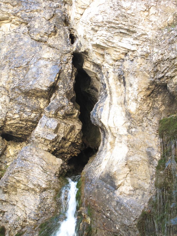
- ↑ Picture with a view of the spring cave. Accessed May 7, 2014.
- ↑ a b c d e f g h John Hooper: Discovery at the Fontana Chistaina . National speleological society. 1956. As PDF ( page no longer available , search in web archives ) Info: The link was automatically marked as defective. Please check the link according to the instructions and then remove this notice. . Accessed May 7, 2014.
- ↑ Information ( Memento of the original dated May 8, 2014 in the Internet Archive ) Info: The archive link was inserted automatically and has not yet been checked. Please check the original and archive link according to the instructions and then remove this notice. of the Engadine power plants to the Assa water catchment . Accessed May 7, 2014.
- ^ Duri Champell: Raetia alpestris topographica descriptio . Published by CJ Kind, Basel 1884.
- ^ Gabriel Walser: Schweitzer geography including the peculiarities in the Alps and high mountains . Zurich 1770.
- ^ Johann Gottfried Ebel: Instructions to travel in Switzerland . Zurich 1810.
- ↑ August Buxtorf & al .: Geological description of the Weissenstein tunnel and its surroundings. A. Francke, 1908.
- ^ Christian Tarnuzzer: Contributions to the geology of the Lower Engadine . A. Francke, 1909.
- ↑ Quoted in: Gregor Burkard: Geological description of the Piz S-Chalambert group. Basler Druck- und Verlaganstalt, 1953.
- ↑ Quoted in: Geological Atlas of Switzerland 1: 25,000. Swiss Geological Commission. 1968.
- ↑ Walter Biese: Cadastre of the Swiss caves. ETH Zurich, 1935.
- ↑ Information on Walter Biese at the Swiss Society for Speleology. Accessed May 7, 2014.
- ↑ PDF of the cadastre. In the foreword, the year of creation of the cadastre is given as 1942/1943, which, however, contradicts the biographical data of Walter Biese.
- ↑ In the publication by John Hooper as Weasel's Creep , referred to by the locals as foura da la müstaila .
- ↑ Swiss Society for Speleology: Stalactite No 3. 1954, pp. 3–6.
- ^ K. Baedeker: Switzerland, Chamonix, the Upper Italian Lakes: Handbook for travelers . 1930
- ↑ English name: English Promenade . Romanesque name: Promenada dals Inglais . German translation not proven.
- ↑ English name: The Court . Romanic and German designations not proven.
- ↑ English name: The Dome . Romanic name: il doma .
- ↑ Note: The Swiss Society for Cave Research drew up a detailed plan of the cave around 1954/1955 and named the cave sections. This information is not publicly available.
- ↑ Theodor F. Anker: Vacation yield from the Lower Engadine . In: Magazin Fledermauspost , No. 1, 1953.
- ↑ Retelling ( Memento of the original from February 8, 2009 in the Internet Archive ) Info: The archive link was inserted automatically and has not yet been checked. Please check the original and archive link according to the instructions and then remove this notice. the legend on the website of the Fundaziun Tschanüff . Accessed May 7, 2014.
- ↑ Excursion documents of the working group “Native Orchids Aargau”. Accessed May 7, 2014.
- ↑ PDF of the Untervaz Castle Association. Accessed May 7, 2014.
- ^ Gian Andrea Caduff: Chiampell at the Funtana Chistagna. Perception of landscape in the 16th century . Bündner Monatsblatt 2/2012, pp. 107–135, online
- ↑ Scan of the Funtana chi staina , doi : 10.5169 / seals-206602
- ↑ Modern orthography (without keeping the meter ): “I nu's pudess chattar a letta insaina / co quella per la poesia, / sbuorflond dal fop dal cour, funtana viva, / chi cur chi sto esser as fa cun forza via / ed oters temps - che don! - dal tuot staliva. "