Gütz
|
Gütz
City of Landsberg
|
|
|---|---|
| Coordinates: 51 ° 32 ′ 3 ″ N , 12 ° 9 ′ 6 ″ E | |
| Residents : | 1315 (2005) |
| Incorporation : | July 1, 1950 |
| Postal code : | 06188 |
| Area code : | 034602 |

Gütz is a district of the locality and town of Landsberg in the Saalekreis in Saxony-Anhalt , Germany. The residential areas Roitzschgen, Düringsdorf, Heiligendorf and Piltitz belong to Gütz .
geography
Gütz joins the urban area of Landsberg in the west. The place is on the Strengbach , a tributary of the Fuhne .
history
The place Gütz, first mentioned in 1287 as "Chutiz", is a Slavic foundation whose moated castle was surrounded by seven ponds connected by ramparts. The following dates for the first mention of the surrounding towns in the Strengbach valley are preserved: Wölls: 1156, Heiligendorf: around 1270, Düringsdorf: 1349/50 as "Duringsdorf", Petersdorf: 1349/50, Roitzschgen: 1380 as "Cleinen Boecz", Piltitz : 1442 as "Biltcz".
While Roitzschgen belonged as an exclave to the Amt Bitterfeld in the Electoral Saxon or Royal Saxon Kurkreis until 1815 , Gütz, Düringsdorf, Heiligendorf, Petersdorf, Piltitz, Wölls and Zschiesdorf were under the administration of the Electoral Saxon Office Delitzsch in the Leipzig district . As a result of the resolutions of the Congress of Vienna , Gütz, Düringsdorf, Heiligendorf, Petersdorf, Piltitz, Wölls, Zschiesdorf and Roitzschgen came to Prussia in 1815 and were assigned to the Delitzsch district in the Merseburg administrative district of the province of Saxony in 1816, to which they belonged until 1950.
In the 19th century, Roitzschgen, Düringsdorf and Heiligendorf merged. The latter consisted of a row of houses between Strengbach and the church of Gütz. In 1888 Wölls and Petersdorf merged into Wölls-Petersdorf. As a result, the newly founded place consisted of Petersdorf, Wölls and the places Piltitz and Zschiesdorf belonging to Wölls. On April 1, 1936, Gütz, Roitzschgen (with Düringsdorf and Heiligendorf) and Wölls-Petersdorf (with Piltitz and Zschiesdorf) merged to form the municipality of Gütz.
In the course of the first district reform in the GDR in 1950, Gütz, like the city of Landsberg, was assigned to the newly tailored hall circle , which in 1952 became the new hall circle in the Halle district . At the same time as it was assigned to the Saalkreis, Gütz and its districts Roitzschgen, Düringsdorf, Heiligendorf and Piltitz were incorporated into Landsberg on July 1, 1950. The district Wölls-Petersdorf was reclassified with Zschiesdorf but without Piltitz to Spickendorf .
Because it was incorporated into Landsberg in 1950, Gütz is now part of the Landsberg area within the city of Landsberg.
coat of arms
The coat of arms was awarded on September 15, 1937 by the President of the Province of Saxony. It was designed by the Magdeburg State Archives Councilor Otto Korn . Blazon : "In blue a golden hammer, the red handle of which is covered with a cross-placed, golden, old Germanic jewelry clasp ( fibula )."
In the village near Piltitz there is the Teufelsstein , an old Germanic sacrificial stone ( menhir ), which was originally probably sacred to the Donar , hence the hammer. The hammer and clasp are located on a memorial stone next to the devil's stone and are considered landmarks of the former community, at whose special request they were included in the coat of arms.
Transport and infrastructure
Gütz is located south of the federal highway 100 , which leads from Halle in the direction of Bitterfeld and connects the A 14 with the A 9 . The nearest train station is in Landsberg on the Berlin – Halle railway line . The largest of the Landsberg industrial areas is located near Gütz.
Attractions
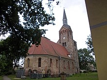
The Gützer Church of St. Anna and St. Katharina was built at the end of the 12th century. Later it was supplemented with late Gothic elements and remodeled in the Baroque style in the 18th century. At the beginning of the 20th century, the teacher Bernhard Brühl laid out a lawn maze on the Gützer Berg and opened a local museum.
Individual evidence
- ↑ Gütz and its districts on the website of the Gütz Church
- ^ Karlheinz Blaschke , Uwe Ulrich Jäschke : Kursächsischer Ämteratlas. Leipzig 2009, ISBN 978-3-937386-14-0 ; P. 22 f.
- ^ Roitzschgen in the book "Geography for all Stands", p. 359
- ^ Karlheinz Blaschke , Uwe Ulrich Jäschke : Kursächsischer Ämteratlas. Leipzig 2009, ISBN 978-3-937386-14-0 ; P. 56 f.
- ^ Gütz and his neighboring towns in the book "Geography for all Stands", p. 514f.
- ^ The district of Delitzsch in the municipality register 1900
- ^ Piltitz on the website of the Gütz Church
- ↑ Zschiesdorf im Landsberger Echo, Volume 24, No. 11 of June 5, 2013, p. 14
- ^ Gütz on gov.genealogy.net
- ↑ Roitzschgen on gov.genealogy.net
- ↑ Wölls-Petersdorf on gov.genealogy.net
- ↑ Incorporation of Gütz on the homepage of the parish of Gollma ( memento of the original from March 5, 2016 in the Internet Archive ) Info: The archive link was automatically inserted and not yet checked. Please check the original and archive link according to the instructions and then remove this notice.
- ^ Spickendorf on the homepage of the city of Landsberg
- ^ History of Gütz on the website of the Gütz Church
Web links
- Gütz on the homepage of the city of Landsberg
- Gütz on gov.genealogy.net
- History of Gütz on the website of the Gütz Church
- Gütz and its incorporations in the Landsberger Echo, Volume 20, No. 12 of October 20, 2010, p. 10

