Gmeinsrieth
|
Gmeinsrieth
Eslarn market
Coordinates: 49 ° 33 ′ 48 ″ N , 12 ° 30 ′ 26 ″ E
|
|
|---|---|
| Height : | 558 m above sea level NN |
| Residents : | 10 (Dec 31, 2012) |
| Incorporation : | 1945 |
| Postal code : | 92693 |
| Area code : | 09653 |
|
Gmeinsrieth
|
|
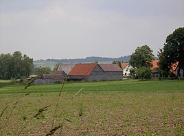
Gmeinsrieth is a village in the Upper Palatinate . The formerly independent community is now part of the Eslarn market .
Geographical location
Gmeinsrieth is located around two kilometers southwest of Eslarn on a cleared area on the pass road to Oberlangau . South of Gmeinsrieth, the 808.6 m high Stangenberg- Stückberg massif forms the border with the Schwandorf district. The neighboring towns are Putzhof in the southwest , Heckermühle in the northeast and Premhof in the east .
history
Gmeinsrieth is one of the oldest settlements that arose at the beginning of the 11th century when the area of today's Eslarn was cleared and settled. These oldest settlements are today's districts of Büchelberg, Putzhof, Oberaltmannsrieth, Putzenrieth, Passenrieth, Gmeinsrieth (originally: Mansenrieth) and Öd (originally: Behaimrieth, which is Böhmer- or Böhmischrieth). The ending -rieth indicates clearing. Originally there was an estate in the Gmeinsrieth area that belonged to the Eslarn manor. It was managed by the men’s servants - hence the original name Mansenrieth. Farms were later divided off from this estate and loaned to farmers. Little by little these farmers became owners of these farms. The colloquial name of Gmeinsrieth, which is still used today, by “on the farms” recalls this process.
1585 Gmeinsrieth was given to Hieronymus Stöckl by Stephan von Paulsdorf as a fief. In 1591 Gmeinsrieth was sold to Count Palatine Johann Kasimir , the guardian of the underage Elector Friedrich IV of the Palatinate .
In 1628 Gmeinsrieth had a mill, 3 farms and 1 hut and paid 10 gulden 8¼ kreuzer annual tax.
After the end of the Thirty Years' War Gmeinsrieth still had 4 households.
The place belonged to the Hofmark Eslarn. In 1818, the municipal edict in Bavaria created the political community of Gmeinsrieth, which was dissolved in 1945 or 1946. Their main place came to Eslarn. Other parts of the community were assigned to the communities of Dietersdorf and Schönsee and thus moved to the district of Oberviechtach .
On March 23, 1913 (Easter), Gmeinsrieth was listed as part of the Eslarn parish with 4 houses and 23 residents. On December 31, 1990 Gmeinsrieth had 10 residents and belonged to the parish of Eslarn.
Individual evidence
- ↑ Tourist Information, Eslarn Town Hall, reference date: December 31, 2012
- ↑ Fritsch hiking map of the Northern Upper Palatinate Forest Nature Park, scale 1: 50,000
- ↑ Hans Schlemmer: History of the Eslarn market. Book and offset printing Spintler Weiden, Regensburg, 1960, pp. 18, 19, 20
- ↑ Hans Schlemmer: History of the Eslarn market. Book and offset printing Spintler Weiden, Regensburg, 1960, p. 19
- ↑ Hans Schlemmer: History of the Eslarn market. Book and offset printing Spintler Weiden, Regensburg, 1960, p. 51
- ↑ Hans Schlemmer: History of the Eslarn market. Book and offset printing Spintler Weiden, Regensburg, 1960, p. 53
- ↑ Hans Schlemmer: History of the Eslarn market. Book and offset printing Spintler Weiden, Regensburg, 1960, p. 74
- ↑ Hans Schlemmer: History of the Eslarn market. Book and offset printing Spintler Weiden, Regensburg, 1960, p. 78
- ^ Wilhelm Volkert (ed.): Handbook of Bavarian offices, communities and courts 1799–1980 . CH Beck, Munich 1983, ISBN 3-406-09669-7 , p. 586 .
- ^ Antonius von Henle (Ed.): Register of the Diocese of Regensburg. Verlag der Kanzlei des Bischöflichen Ordinariates Regensburg, 1916, p. 326
- ↑ Manfred Müller (Ed.): Register of the diocese of Regensburg. Verlag des Bischöflichen Ordinariats Regensburg, 1997, p. 161


