
Gmina Łask
| Gmina Łask | |||
|---|---|---|---|

|
|
||
| Basic data | |||
| State : | Poland | ||
| Voivodeship : | Łódź | ||
| Powiat : | Łaski | ||
| Geographic location : | 51 ° 35 ′ N , 19 ° 8 ′ E | ||
| Residents : | s. Gmina | ||
| Postal code : | 98-100 | ||
| Telephone code : | (+48) 43 | ||
| License plate : | ELA | ||
| Economy and Transport | |||
| Street : | DK12 Kalisz - Radom | ||
| DK14 Łódź - Łowicz | |||
| Rail route : | Łódź – Ostrów Wielkopolski | ||
| Next international airport : | Łódź | ||
| Gmina | |||
| Gminatype: | Urban-and-rural parish | ||
| Gmina structure: | 50 villages | ||
| 32 school offices | |||
| Surface: | 146.0 km² | ||
| Residents: | 27,724 (Jun. 30, 2019) |
||
| Population density : | 190 inhabitants / km² | ||
| Community number ( GUS ): | 1003023 | ||
| Administration (as of 2006) | |||
| Mayor : | Gabriel Szkudlarek | ||
| Address: | ul.Warszawska 14 98-100 Łask |
||
| Website : | www.lask.pl | ||

The Gmina Łask [ wask ] is an urban-and-rural municipality in the Powiat Łaski of the Łódź Voivodeship in Poland . The seat of the Powiat and the municipality is the city of the same name ( German Lask ) with about 17,250 inhabitants.
geography
_location_map.png)
The municipality is located in the center of the voivodeship, the city of Zduńska Wola is five kilometers to the west, Pabianice ten kilometers and Łódź about 20 kilometers to the east. Neighboring municipalities are Buczek , Dobroń , Sędziejowice , Szadek , Wodzierady , Zelów and Zduńska Wola . The Grabia , a 77-kilometer tributary of the Widawa , is one of the rivers .
The community has an area of 146 km², 70 percent of which is used for agriculture and 18 percent for forestry.
history
On September 10, 1953, the rural community Gmina Wiewiórczyn was renamed Gmina Łask and a year later it was transformed into several Gromadas . On January 1, 1973 the municipality Łask was newly created. She came to the Sieradz Voivodeship from 1975 to 1998 , which only existed in modern Poland at that time.
Partnerships
On November 6, 1999, the municipality with the city of Dannenberg (Elbe) entered Lower Saxony , after the formation of the Elbtalaue municipality , this was expanded to include the municipality in June 2008. A partnership with the Belarusian city of Lahojsk has existed since January 2004 .
structure
In addition to the city itself, the city-and-rural community (gmina miejsko-wiejska) Łask includes 32 villages with a school administration office (sołectwo):
- Aleksandrówek
- Anielin
- Bałucz
- Borszewice
- Budy Stryjewskie
- Gorczyn
- Karszew
- Kopyść
- Krzucz
- Łopatki
- Mauryca
- Okup Mały
- Okup Wielki
- Orchów
- Ostrów
- Rembów
- Draw
- Rokitnica
- Sięganów
- Stryje Księże
- Stryje Paskowe
- Teodory
- Wiewiórczyn
- Wola Bałucka
- Wola Łaska
- Wola Stryjewska
- Wronowice
- Wrzeszczewice
- Wrzeszczewice Nowe
- Wydrzyn
- Zielęcice
Other small towns in the municipality are:
- Grabina
- Jabłonki
- Kolonia Bałucz
- Kolonia Bilew
- Łętków
- Łopatki-Cegielnia
- Mikołajówek
- Młynisko
- Orchów-Wesółka
- Ostrów-Osiedle
- Podłaszcze
- Szadek
- Teodory-Osiedle
- Ulejów
- Wincentów
- Wrzeszczewice-Skrejnia
- Wrzeczewice-Tomaszew
Listed sights
- Church in Borszewice Koscielne, built 1894–1902
- Manor house in Gorczyn (18th / 19th century)
- Manor house in Karszew (19th century, dismantled)
- Parish church in Łask, built in 1525 and 18th centuries
- Wooden church in Łask, built in 1666
- City park in Łask, formerly the park of the manor house (18th century)
- House in Łask, Kosciuszki 2 (1909)
- House in Łask, 11 Listopada 1 (19th century)
- House in Łask, 11 Listopada 2 (19th century)
- House in Łask, 11 Listopada 3 (19th century)
- House in Łask, 11 Listopada 6 (19th century)
- House in Łask, 11 Listopada 7 (19th century)
- Fortified manor in Łopatki (16th century)
- Manor in Ostrów (early 20th century)
- Manor house in Wola Bałucka
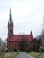
Church in Borszewice
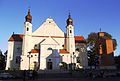
Parish church in Łask

Wooden church in Łask
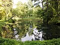
Park in Łask

House 11 Listopada 2 in Łask

House 11 Listopada 7 in Łask

Good in Łopatki
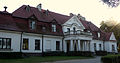
Manor in Ostrów


_-_18_20120928175.jpg)


traffic
The most important roads are the national road DK12 in the west-east direction and the DK14 in the north-south direction. Łódź is the nearest international airport, the Łask military airfield has no civil area.
The city has a long-distance station on the Łódź – Ostrów Wielkopolski – Forst (Lausitz) railway line , which is also used by the residents of the surrounding communities.
Web links
Individual evidence
- ↑ population. Size and Structure by Territorial Division. As of June 30, 2019. Główny Urząd Statystyczny (GUS) (PDF files; 0.99 MiB), accessed December 24, 2019 .
- ↑ a b regioset.pl: data on the municipality (Polish, accessed March 30, 2020)
- ↑ Sejm's document server : Rozporządzenie Prezesa Rady Ministrów z dnia 10 września 1953 r. w sprawie zmiany nazw niektórych gmin w województwie łódzkim . (Polish, accessed March 30, 2020)
- ↑ lask.pl: Miasta partnerskie . (Polish, accessed March 30, 2020)
- ↑ NID : Informational directory of the list of monuments of the Łódź Voivodeship (as of March 31, 2016) (PDF, 500kB; Polish, accessed on March 23, 2020) p. 17.
- ↑ Registered in the list of monuments of the Łódź Voivodeship under number A / 99 on December 16, 2010.
- ↑ Registered in the list of monuments of the Łódź Voivodeship under the number 371-IV-33 on October 12, 1946.
- ↑ Registered in the list of monuments of the Łódź Voivodeship under the number 435 on July 24, 1967.
- ↑ Registered in the list of monuments of the Łódź Voivodeship under number 40 on July 19, 1967.
- ↑ Registered in the list of monuments of the Łódź Voivodeship under number 41 on July 19, 1967.
- ↑ Registered in the list of monuments of the Łódź Voivodeship under number 386 on June 25, 1990.
- ↑ Registered in the list of monuments of the Łódź Voivodeship under number 391 on October 28, 1991.
- ↑ Registered in the list of monuments of the Łódź Voivodeship under the number 422 on July 19, 1967.
- ↑ Registered in the list of monuments of the Łódź Voivodeship under number 423 on July 19, 1967.
- ↑ Registered in the list of monuments of the Łódź Voivodeship under number 424 on July 19, 1967.
- ↑ Registered in the list of monuments of the Łódź Voivodeship under the number 425 on July 19, 1967.
- ↑ Registered in the list of monuments of the Łódź Voivodeship under the number 426 on July 19, 1967.
- ↑ Registered in the list of monuments of the Łódź Voivodeship under numbers 550-IV-42 (June 30, 1950) and 60 (July 24, 1967).
- ↑ Registered in the list of monuments of the Łódź Voivodeship under number 379 on December 29, 1989.
- ↑ Registered in the list of monuments of the Łódź Voivodeship under the number 300 on October 15, 1980.