Grodziec (Ozimek)
| Grodziec Friedrichsgrätz |
||
|---|---|---|

|
|
|
| Basic data | ||
| State : | Poland | |
| Voivodeship : | Opole | |
| Powiat : | Opole | |
| Gmina : | Ozimek | |
| Geographic location : | 50 ° 42 ′ N , 18 ° 17 ′ E | |
| Residents : | 1362 (Oct. 31, 2018) | |
| Postal code : | 46-043 | |
| Telephone code : | (+48) 77 | |
| License plate : | OPO | |
| Economy and Transport | ||
| Street : | DK 46 Kłodzko - Częstochowa | |
| Next international airport : | Katowice | |
Grodziec ( German Friedrichsgrätz ) is a village in Upper Silesia . Grodziec is located in the urban and rural municipality of Ozimek (Malapane) in the Powiat Opolski (Opole district) in the Polish Opole Voivodeship .
geography
Geographical location
Grodziec is located six kilometers northeast of the municipality of Ozimek (Malapane) and 28 kilometers east of the district town and the provincial capital of Opole (Opole).
The regional road Droga krajowa 46 runs through the village . The village lies in the middle of extensive forest areas. The Białka , a right tributary of the Mała Panew (Eng. Malapane ), flows through Grodziec .
Neighboring places
Neighboring towns of Biestrzynnik are Chobie in the north and Mnichus ( Münchhausen ) in the southeast .
history
The village was founded as a colony in 1752 by the Hussites from Bohemia during the Frederician colonization. The village was mostly populated with religious refugees from Bohemia, who immigrated in large numbers to Prussia after the First Silesian War . Friedrichsgrätz is still one of the largest settlements from the Frederician colonization. In 1756 the place had 71, in 1787 101 places. In 1787, 45 weavers and 40 other craftsmen lived in the village, most of whom spoke Czech .
After the reorganization of the province of Silesia which belonged rural community of Friedrich Graetz from 1816 to district Opole in the administrative district of Opole . In 1845 the Czech place name is mentioned as Frydrychowy Hradec and the Polish place name as Grec . In 1845 there was a Protestant parish church, a Protestant school, a distillery, a brewery, a forest ranger's office and 162 other houses in the village. In the same year, 1117 people lived in Friedrichsgrätz, 45 of them Catholic. In 1845 there were also 48 shoemakers, 31 linen weavers and 20 weavers. In 1865 the place had 94 colonists. In 1874 the district of Friedrichsgrätz was founded, which consisted of the rural communities of Chobie, Friedrichsgrätz and Münchhausen. The administrative district was initially administered by the mill owner Adametz in Krascheow. Around 1880 the Friedrichsgrätz district was dissolved and assigned to the Krascheow district.
In 1910, 1790 lived in Friedrichsgrätz, 1679 of them were Czechs. In the referendum in Upper Silesia in 1921, 1,239 eligible voters voted for Germany and 13 for Poland. Friedrichsgrätz remained in the Weimar Republic after 1922 . In 1933 there were 1,906 inhabitants in Friedrichsgrätz, in 1939 1,810 inhabitants. Until 1945 the place was in the district of Opole .
In 1945 the place came under Polish administration and was renamed Grodziec, the population was expelled. The first Polish settlers reached the village as early as April 1945, mainly from Verkhnya Bilka and Jezierna . In 1950 Grodziec came to the Opole Voivodeship. In 1999 the place came to the re-established Powiat Oleski . In 2011, 1336 people lived in the village.
Attractions
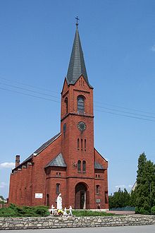
- The Roman Catholic Church of Our Lady of Częstochowa and St. Adalbert was built in 1891 as a Protestant church in neo-Gothic style. Catholic masses have been celebrated in the church since summer 1945.
- School building - two-story brick building from 1845 at ul. Tartaczna
Personalities
- Fritz Streletz (* 1926), Deputy Minister of Defense of the GDR
Web links
Individual evidence
- ↑ a b Population Gmina Ozimek (Polish), October 1, 2018, accessed on April 3, 2019
- ^ A b Walter Kuhn: Settlement history of Upper Silesia . Oberschlesischer Heimatverlag, Würzburg. 1954. pp. 202f.
- ^ Johann Georg Knie : Alphabetical-statistical-topographical overview of the villages, spots, cities and other places of the royal family. Preuss. Province of Silesia. Breslau 1845, p. 138f.
- ↑ Cf. Felix Triest: Topographisches Handbuch von Oberschlesien , Breslau 1865
- ^ Territorial district of Friedrichsgrätz / Schönhorst
- ↑ See results of the referendum in Upper Silesia of 1921 ( Memento of January 24, 2017 in the Internet Archive )
- ↑ Michael Rademacher: German administrative history from the unification of the empire in 1871 to the reunification in 1990. Opole district (Polish Opole). (Online material for the dissertation, Osnabrück 2006).
- ^ CIS 2011: Ludność w miejscowościach statystycznych według ekonomicznych grup wieku (Polish), March 31, 2011, accessed on April 3, 2019
- ↑ Catholic Church in Grodziec


