
Amalienhöhe pit
| Amalienhöhe pit | |||
|---|---|---|---|
| General information about the mine | |||
 |
|||
| other names | Dr. vulture | ||
| Information about the mining company | |||
| Operating company | Union of Dr. Geier (from 1904) Mannesmann (from 1927) |
||
| Employees | 1018 (1917) 204 (1969) |
||
| Start of operation | 1885 | ||
| End of operation | 1971 | ||
| Funded raw materials | |||
| Degradation of | Manganese ore , dolomite | ||
| Greatest depth | 267 m (violet or Rhine bed) | ||
| Geographical location | |||
| Coordinates | 49 ° 57 '32.2 " N , 7 ° 50' 19.8" E | ||
|
|||
| local community | Waldalgesheim | ||
| ( NUTS3 ) | Mainz-Bingen district | ||
| country | State of Rhineland-Palatinate | ||
| Country | Germany | ||

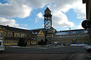
The Amalienhöhe pit (also called the Dr. Geier pit) is located above Waldalgesheim near Bingen on the edge of the Hunsrück . The listed former manganese and dolomite mine is unique among the industrial monuments in Germany due to its architecture . The Amalienhöhe pit has been part of the Upper Middle Rhine Valley UNESCO World Heritage Site since 2002 .
history


In 1885, the Mainz began Heinrich Claudius vultures in the newly developed mining area Amalienhöhe search bays abzuteufen and pushed at a depth of 18 m to a mineral deposit . The ore was extracted from 1887, initially using piers and later using the shaft construction method . Manganese ore was used as an additive in steel processing . After the death vulture on 22 January 1898, the family business in 1904 by the heirs to the 1000 Kuxe banded union Doctor Geier manganese mines converted. In 1911, under the direction of the geologist Ernst Esch, the neighboring Elisenhöhe pit of the Wandesleben brothers and their entire mine field property were acquired. In 1912 a 7.6 km long cable car with a capacity of up to 60 tons per hour was built to a loading station on the Rhine near Trechtingshausen . In 1913 production exceeded the 100,000-ton limit for the first time. The Rhine tunnel, which had been planned since 1899 and whose mouth is north of Bingerbrück near the banks of the Rhine, was set up in 1914 and, in addition to the joint dewatering of both pits, served to develop further ore deposits at greater depths .
At the beginning of the First World War in 1914, the mines were initially closed, but the Amalienhöhe mine was able to be put back into operation in October of that year, and the Elisenhöhe mine followed in 1915. From this time on, Russian prisoners of war came to work. Since the German Reich was cut off from foreign sources of supply during the First World War and the demand for manganese ores for steel production increased significantly, the opportunity arose for further expansion. From 1916 on, the new Dr. Geier , of which the Reich contributed half of the construction costs. In 1917, approx. 240,000 tons, the highest amount of manganese ore in the company's history was mined.
With the takeover of 673 Kuxen by the Mannesmannröhren-Werke in 1918, the latter gained a dominant influence on the company. At that time, 287 Kuxe were owned by Friedrich Krupp AG , 40 Kuxe were owned by a Baron de Curel. In 1927 the union was able to acquire the Krupp shares, the following year that of Baron de Curel and thus became a wholly owned subsidiary of Mannesmannröhren-Werke.
The years after the First World War were repeatedly characterized by sales difficulties and temporary shutdowns, and it was not until 1936 that the 100,000-tonne limit was exceeded again for the first time.
In April 1938 the Bonn Oberbergamt moved the safety pillar, which had been laid down to protect the town of Waldalgesheim, further south in order to be able to mine the ore within the pillar. This was preceded by a demand to this effect by Hermann Göring , who was responsible for the four-year plan for arming Germany. In 1941 another relocation to the south took place. With a flow rate of almost 160,000 tons, the highest level since the First World War was reached in 1944.
On December 31, 1952, the Dr. Geier dissolved and transferred to the Mannesmann union .
Since it became apparent as early as 1952 that no further manganese ore deposits worth mentioning could be explored, considerations were made to convert mining to dolomite . A first supply contract was signed in 1954 with the Hütten- und Bergwerke Rheinhausen AG of the Krupp company. From January 1959, mainly dolomite was extracted from the pit. With around 350,000 tons of raw dolomite extraction in 1969, the largest output was achieved.
When the large steelworks switched their steel production from the Siemens-Martin process to the oxygen steel process in the years to come, dolomite was no longer required to refine the steel. As a result, the demand for dolomite collapsed dramatically and the mine had to close in 1971. By the time it was closed, 5.5 million tons of manganese ore and 2.6 million tons of dolomite had been mined.
The buildings

The Darmstadt planning office Markwort & Seibert , civil engineer Georg Markwort and architect Eugen Seibert , created a plan in the neo-baroque style from 1916 . The buildings are arranged almost axially symmetrically around a kind of courtyard . Behind the portal, the courtyard is flanked by two villa-like buildings. The colliery house on the left contained the management and administration, the building office, officials' mess and apartments were housed in the hostel opposite . The hall building follows a little to the rear . It is the most elaborate building and housed a dining room as well as a theater and lecture room. On the right-hand side, there is the actual company building with a storage room, wages hall, chow and ore silo with headframe. The courtyard is delimited by the transverse machine hall , in front of which an octagonal fountain that serves as a cooling pond is placed. The workshop follows behind .
Still used as a visitor mine for a short time , the structure of the no longer used buildings is slowly deteriorating today. In 2003 a large fire destroyed the former vehicle hall. Since the new community of owners broke up, nothing has come of the promised renovation measures so far. At the moment, individual buildings are rented to different residents and companies. In April 2012, the roofing of the winding tower and the fire bowl that closed it were removed, and in February 2013 the decision was made to demolish the entire tower for safety reasons, as it threatens to break apart due to advanced corrosion. The demolition order was given on the condition that the owner must erect a comparable tower by 2030 at the latest. After the water tank and the entire roof structure had been completely dismantled in mid-December 2013, the tower threatened to fall on the surrounding buildings in early January 2014. For safety reasons, the company commissioned with the demolition decided to demolish the tower at short notice. The steel frame was brought to collapse by means of targeted pressure using a steel cable. The ore bunker and machine hall were damaged, the surrounding houses remained intact.
Mine buildings and infrastructure
![]() Map with all coordinates: OSM | WikiMap
Map with all coordinates: OSM | WikiMap
The pit is connected to the surface by at least 5 tunnels :
- Rhine tunnel, built from March 1914, due to war damage not completed until 1924, 3300 m long, deepest water solution tunnel and conveyor tunnel, from the Amalienhöhe pit to the Rhine (planned since 1899), is still used today for the water solution location
- Bingerloch tunnel, built in 1894, 775 m long, water solution tunnel and conveyor tunnel, from Elisenhöhe pit to the Rhine ( location )
- Lower Geyger tunnel, 350 m long, from 1916, named after the mine owner Finanzrat a. D. Geyger, finished 1922 location
- Oberer Geygerstollen, initially 850 m long, from 1916, named after the mine owner Finanzrat a. D. Geyger, provisionally finished in 1922, from 1940 on working from the tunnel mouth hole at the Schwarzkalkbruch and from the Heerberg shaft from Lage
- Stollen (water-dissolving) location
There are at least 10 shafts :

- Straub shaft (main shaft Amalienhöhe) inside diameter 5 m, started in 1917, reached 1925 a depth of 211 m, 1929 he reaches the riverbed (Violet sole) at 267 m, in July In 1929 the breakdown to the Rhine tunnel location
- Schacht Weiler-West is 1958 to the depth of the riverbed (267 m) drilled location
- Hermann shaft, started in 1898, near the Weiler-West shaft (at Elisenhöhe)
- Schacht Waldalgesheim, begun in 1904 location
- Old Amalienhöhe shaft, reached 62 m depth in 1889, miners ride on stairs carved into the sandstone
- New shaft Amalienhöhe started, 1890 Location
- Heerberg shaft location
- Hey shaft, up to the yellow sole, started in 1929, is located west of Waldalgesheim
- Digging shaft, 80 m depth, started in 1903, (today Dittloff-Weiher, west of Weiler)
- Wetterschacht Kaes, commissioned in 1924 (enough to yellow sole) location
Starting from the Straubenschacht there are 5 soles , which were named according to the spectral colors from 1914:
- Orange sole
- Yellow sole at 115 m depth
- Green sole at 134 m depth, exposed from 1934
- Blue sole
- Violet bottom at 267 m depth (= Rhine bottom)
Infrastructure:
- Cable car station Elisenhöhe Lage ,
- Angular station cable car location
- Angular station at the ore bunker Amalienhöhe Lage
- End of the cable car at the Lage loading bridge
Rotary kiln: location
Waschkaue Schacht Weiler West: Location
Dismantling method:
1887 pillar construction (upwards, with offset)
1940s transverse fracture construction
1952 partly (below Waldalgesheim to protect the existing building stock): Ridge joint construction with mountain offset
1958 Block construction with framed timber
1959 Dolomite extraction in magazine construction
Mountain damage and effects on Waldalgesheim

As early as 1908, more and more mountain damage became apparent in the old town center. There were fractures that led to subsidence and gradually filled with water. Numerous buildings were damaged over time and had to be abandoned. Entire streets fell victim to the subsidence. From around 1910, 124 new houses were built south of the old town center. The abandoned buildings were demolished. The two churches also had to be put down and rebuilt elsewhere.
Due to the great demand for manganese ores by the armaments industry, an application was made to the Bonn Oberbergamt to relocate the safety pillar in order to enable further mining there. The union was ordered to buy up the land at risk, but the landowners concerned initially refused. An agreement was reached in 1916 under pressure from state and church institutions and the threat of expropriation. In the summer of 1916, the construction of the first replacement houses began at the expense of the union; the planning was carried out by the Markwort & Seibert office, as was the case with the new mine. Around 60 new buildings had been erected by 1920.
In 2008, with the help of Heimatfreunde Waldalgesheim, the foundation walls of the church next to the old cemetery were exposed again. Today walkers will find Bruchfeldteiche in the place of the former town center. The ponds in the area of the subsidence have been declared a nature reserve.
Minerals
During the operation of the mine, the following minerals were found in the ores extracted:
gallery

Machine hall, ore silo, headframe, laundry / wage hall

Hostel and hall construction. Fountain system in the foreground
Machine hall, winding tower and laundry / wage hall
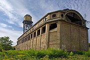
Ore silo with headframe

Headframe after removal of the roofing and the final fire bowl
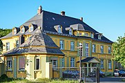
Gatehouse and colliery / director's seat

Headframe detail

Bingerloch tunnel


.jpg)


literature
- Klaus Klemp : Dr. Vulture. Monument to the German ore mining. Verlag im Biebertal, 1987, ISBN 3-9801447-0-4 . With prefaces by Bernhard Vogel and Rainer Slotta , assessment by Heinrich Klotz .
Individual evidence
- ^ General Directorate for Cultural Heritage Rhineland-Palatinate (ed.): Informational directory of cultural monuments - Mainz-Bingen district. Mainz 2020, p. 106 (PDF; 7.9 MB).
- ↑ Valuable investment threatens collapse Allgemeine Zeitung of January 4, 2013
- ↑ Landmark will be demolished Allgemeine Zeitung from February 2, 2013
- ↑ Unplanned drastic end - the headframe crashes into two buildings in the Dr. Geier Allgemeine Zeitung from January 2, 2014
- ↑ a b c Klaus Klemp: Dr. Geier - Monument to German ore mining . Verlag im Biebertal, 1987, ISBN 3-9801447-0-4 , p. 32 .
- ↑ a b Klaus Klemp: Dr. Geier - Monument to German ore mining . Verlag im Biebertal, 1987, ISBN 3-9801447-0-4 , p. 20 .
- ↑ Klaus Klemp: Dr. Geier - Monument to German ore mining . Verlag im Biebertal, 1987, ISBN 3-9801447-0-4 , p. 26 .
- ↑ a b c Klaus Klemp: Dr. Geier - Monument to German ore mining . Verlag im Biebertal, 1987, ISBN 3-9801447-0-4 , p. 14 .
- ↑ Klaus Klemp: Dr. Geier - Monument to German ore mining . Verlag im Biebertal, 1987, ISBN 3-9801447-0-4 , p. 15 .
- ↑ Klaus Klemp: Dr. Geier - Monument to German ore mining . Verlag im Biebertal, 1987, ISBN 3-9801447-0-4 , p. 85 .
- ↑ Klaus Klemp: Dr. Geier - Monument to German ore mining . Verlag im Biebertal, 1987, ISBN 3-9801447-0-4 , p. 27 .
- ↑ Klaus Klemp: Dr. Geier - Monument to German ore mining . Verlag im Biebertal, 1987, ISBN 3-9801447-0-4 , p. 23 .
- ↑ Klaus Klemp: Dr. Geier - Monument to German ore mining . Verlag im Biebertal, 1987, ISBN 3-9801447-0-4 , p. 28 .
- ^ German topographic map - sheet 5913 Presberg , Reichsamt für Landesaufnahme 1935, updated 1951 by Army Map Service, digitized , accessed on April 10, 2016.
- ^ German topographic map - sheet 6013 Bingen , Landesvermessungsamt Rheinland-Pfalz 1955, updated 1955 by Army Map Service, digitized , accessed on April 10, 2016.
- ↑ Klaus Klemp: Dr. Geier - Monument to German ore mining . Verlag im Biebertal, 1987, ISBN 3-9801447-0-4 , p. 37 .
- ↑ Klaus Klemp: Dr. Geier - Monument to German ore mining . Verlag im Biebertal, 1987, ISBN 3-9801447-0-4 , p. 39 .
- ↑ Klaus Klemp: Dr. Geier - Monument to German ore mining . Verlag im Biebertal, 1987, ISBN 3-9801447-0-4 , p. 40 .
- ↑ Landmark of Waldalgesheim Homepage of the city of Waldalgesheim
Web links
- Landmark of Waldalgesheim
- Dr. Geier architectural photographs of the Amalienhöhe pit by the MOnuMENTE photo group