
Gschnaidt (municipality of Gratwein-Straßengel)
|
Gschnaidt (former municipality) locality  Cadastral community Gschnaidt |
|||
|---|---|---|---|
|
|||
| Basic data | |||
| Pole. District , state | Graz-Umgebung (GU), Styria | ||
| Judicial district | Graz-West | ||
| Coordinates | 47 ° 8 '12 " N , 15 ° 11' 8" E | ||
| height | 769 m above sea level A. | ||
| Residents of the village | 316 (January 1, 2020) | ||
| Building status | 170 (2011 ) | ||
| Area d. KG | 29.96 km² | ||
| Postcodes | 8103, 8113, 8114, 8153 | ||
| prefix | + 43/3124 (Gratkorn) | ||
| Statistical identification | |||
| Community code | 60664 | ||
| Locality code | 14941 | ||
| Cadastral parish number | 63225 | ||
| Counting district / district | Gschnaidt (60664 009) | ||
 The former municipality in the Graz-Umgebung district |
|||
| Independent municipality until the end of 2014 Source: STAT : Local directory ; BEV : GEONAM ; GIS-Stmk |
|||

Gschnaidt is a village, cadastral community and former municipality with 316 inhabitants (as of January 1, 2020) in Styria in the northwest of the Graz-Umgebung district .
As part of the structural reform of the Styrian community , it was merged with the communities of Judendorf-Straßengel , Eisbach and Gratwein in 2015 ; the new community is called Marktgemeinde Gratwein-Straßengel . The basis for this is the Styrian Municipal Structural Reform Act - StGsrG. A complaint brought by the municipality against the amalgamation to the Constitutional Court was unsuccessful.
geography
Geographical location
Gschnaidt is located approx. 25 km northwest of the provincial capital Graz in the Stübinggraben , a side valley of the Mur valley . The highest peaks in the municipality are the Heiggerkogel (1,098 m) and the Pleschkogel (1,061 m).
structure
The former municipality consisted of a single cadastral municipality or village of the same name . The main town is the pilgrimage site Sankt Pankrazen , a hamlet on a mountain ridge, otherwise there are:
- the hamlet of Kornberg ,
- the scattered houses Krienz , Plesch , Sankt Pankrazen (surroundings) , Stiwollgraben , Stübinggraben ,
- and numerous individual layers (Abraham, Ambros, Enzianhof, Fuchs, Grabenfödl, Grabenwarter, Hasi, Hidner, Höfer, Kalbacher, Kesselmeixner, Klein-Lückanderl, Knoblacher, Kogler, Kohlbauer, Kreuzwirt, Lenzbauer, Lück, Marxbauer, Moises, Pagger, Platzl, Pleschwirt, Ponkratzbauer, Prettenthaler, Rattich, Riemer, Saupart, Steinklauber, Thurner, Wolf am Egg, Zuri) ,
a typical settlement situation for the area.
Incorporations

As part of the structural reform of the Styrian community , the community of Gschnaidt was merged with the communities of Gratwein , Eisbach and Judendorf-Straßengel in 2015 .
Former neighboring communities
| Geistthal ( district Voitsberg ) | Ubelbach | Großstübing |
.svg)
|
Eisbach | |
| Södingberg ( District Voitsberg ) | Stiwoll |
history
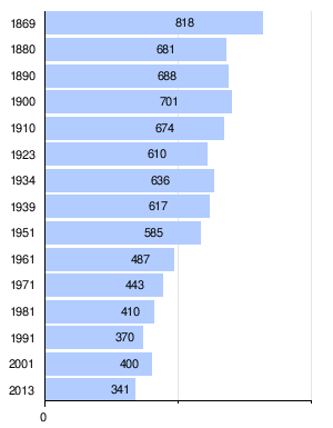
Population development
Economy and Infrastructure
traffic
Gschnaidt is located off the main roads. The closest motorway connection to the Pyhrn motorway A 9 is the Deutschfeistritz junction (165) about 19 km away. There is also access to Grazer Straße B 67, which is also possible via Gratkorn at the same distance .
A train station is neither in town nor in the vicinity. The closest rail connection is the Gratwein -Gratkorn train station to the Austrian Southern Railway , about 15 km away.
The Graz Airport is about 35 km away.
politics
Municipal council
The last municipal council consisted of nine members and, since the municipal council elections in 2010, consisted of mandates from the following parties:
- 6 List of citizens for Gschnaidt - provided by mayor and vice mayor
- 3 ÖVP - provides the community cashier
The last mayor since 2005 was Max Höfer (list of citizens), Vice Mayor was Hubert Perstaller (list of citizens, previously SPÖ)
coat of arms
The municipal coat of arms was awarded with effect from June 1, 1992. Due to the amalgamation of the municipalities, these lost their official validity on January 1, 2015.
Blazon (coat of arms description):
- "In the raised and lowered silver section in the green middle field, divided by tin cuts, a silver votive offering in the form of a standing cattle, accompanied by three smoothly cut three-leaf beech branches in the shield head and two smoothly cut four-leaf red beech branches in the shield base."
Culture and sights
Web links
Individual evidence
- ↑ Statistics Austria: Population on January 1st, 2020 by locality (area status on January 1st, 2020) , ( CSV )
- ^ Styrian municipal structural reform .
- ↑ Section 3, Paragraph 3, Item 3 of the Act of December 17, 2013 on the reorganization of the municipalities of the State of Styria ( Styrian Municipal Structural Reform Act - StGsrG). Provincial Law Gazette for Styria of April 2, 2014. No. 31, year 2014. ZDB -ID 705127-x . P. 3.
- ↑ recognition of the Constitutional Court of 25 November 2014 G 121/2014.
- ^ The State of Styria: The new municipal structure of Styria. (No longer available online.) Formerly in the original ; Retrieved November 9, 2013 . ( Page no longer available , search in web archives ) Info: The link was automatically marked as defective. Please check the link according to the instructions and then remove this notice.
- ↑ Communications from the Styrian State Archives 42/43, 1992/93, p. 48

Cadastral communities: Eisbach | Gratwein | Gschnaidt | Hearing gas | Judendorf street angel | Kehr and Plesch
Locations: Eisbach | Hearing gas | Gratwein | Gschnaidt | Hundsdorf | Judendorf | Kehr and Plesch | Kugelberg | Pure | Rötz | Street angel
Market places: Gratwein • Judendorf Villages: Sankt Pankrazen • Straßengel Settlements: Au • Reinersiedlung Rotten: Greith • Hart • Hundsdorf • Kierl • Kornberg • Kugelberg • Meierhof • Rein • Rötz • Selenz • Tallak
Scattered houses: Enzenbach • Hart • Hausegg • Hörgas • Kehr • Krienz • Plesch • Sankt Pankrazen (surroundings) • Schirning • Stiwollgraben • Stübinggraben
Almen Bockstaller Other local documents: Grabenfödl • Landesgut Hörgas • Regional Hospital Enzenbach • Regional Hospital Hörgas • Mühlbacherhütte • Josefsheim • Murmühle • Ortisei • Cistercian Abbey Rein
Counting district: Gratwein-Nord | Gratwein-Süd | Judendorf | Straßengel-Süd | Street Gel Center | Straßengel-Nord | Judendorf-Straßengel-W | Hörgas-Kehr and Plesch | Eisbach-Rein | Gschnaidt